

“Discuss the problems of erosional surfaces and explain the different methods to identify them with suitable diagrams.” (2020)
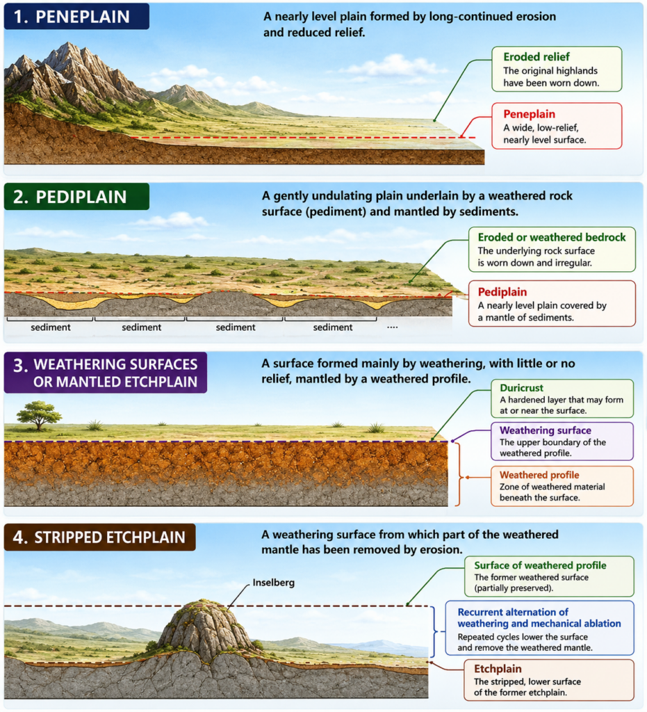
- Erosional (planation) surfaces — the peneplains, pediplains, and related low-relief end-forms produced by the geomorphic cycles of W.M. Davis, L.C. King, and Walther Penck — exist today only as fragments: dissected, partly buried, uplifted, or tilted remnants rather than the complete, continuous plains the original cyclic theories describe, and reconstructing them from what survives is the central methodological challenge of denudation chronology.
- R.J. Small’s formulation captures the task precisely: the goal of the denudation-chronology approach is “to identify, date and interpret planation surfaces developed in past cycles and sub-cycles of erosion on the basis of evidences of drainage development, river capture, relic surfaces and past tectonic events” — a goal that is far harder to achieve than to state, because the very processes that destroyed most of the original surface are the same ones an investigator must use indirect evidence to see through.
- The thesis argued here: the problems of erosional surfaces are fundamentally problems of incomplete, ambiguous, and undatable evidence, and every method geomorphologists have developed to identify and correlate these surfaces — from summit accordance and altimetric analysis to duricrust correlation and drainage anomalies — is best understood as a specific technique for compensating for one of these evidentiary gaps.
The Core Problem: Fragmentary and Heavily Modified Evidence
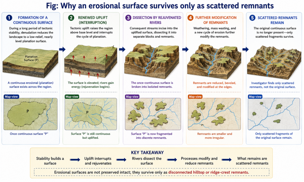
- Fragmentation: the single most serious problem is that an erosional surface is, almost by definition, only partly preserved — the same criticism levelled against denudation chronology as a whole is that it “succeeds in explaining directly only very small parts of the existing landscape, namely the fragments of former (erosion) surfaces which have been dissected and almost totally destroyed in some cases by more recent erosion.”
- Speculative reconstruction: because old erosion surfaces and their remnant forms have been so heavily modified by subsequent processes, it becomes difficult or even impossible to recover their original form and initial height with confidence — any reconstruction necessarily involves a degree of inference that cannot be independently verified against the vanished original surface.
- Dating difficulty: erosional surfaces are notoriously hard to date directly, since valid geological evidence (datable strata, fossils, or radiometric material) is frequently absent from a bare, denuded rock surface — a surface can often be bracketed only indirectly, from the age of whatever younger deposits happen to rest upon it or the age of the youngest rock it truncates.
- The palimpsest problem: the concept of palimpsest topography — a landscape “written” by one set of geomorphic processes, partially “erased,” and then “rewritten” by later processes, analogous to a manuscript scraped clean and reused — means several generations of surfaces can be superimposed and interwoven at a single location, making it genuinely difficult to separate which landscape elements belong to which erosional episode.
- “The degree of precision of landform analysis rests on the deductive power of the researcher and the level of qualitative and quantitative description of relic features” — a candid acknowledgement that identifying erosional surfaces is as much an exercise in disciplined inference as in direct observation.
- Correlation across distance: even where a fragment is confidently identified as a relict surface, correlating it with other fragments elsewhere in the region — to confirm they belong to the same former surface rather than two different ones of similar appearance — is itself a further, separate problem, since tectonic tilting, faulting, and differential erosion can leave once-continuous surfaces standing at quite different elevations today.
Method 1: Summit Accordance and the Altimetric Frequency Curve
- The most basic field method is summit accordance — observing that hilltops and ridge crests across a region rise to a strikingly similar elevation despite being separated by intervening valleys, taken as visual evidence that these summits are remnants of what was once a single, continuous, now-dissected surface.
- This qualitative impression is made rigorous through the altimetric frequency curve: elevations are sampled systematically across the study area (from spot heights, summit points, or the highest point in each grid square of a topographic map) and plotted as a frequency distribution against altitude.
- A peak (mode) in the frequency curve at a particular elevation band indicates that an unusually large number of sampled points cluster at that height — interpreted as the signature of a former planation surface, since a genuine erosional surface concentrates many summit points at nearly the same elevation, whereas a landscape with no inherited planation surface would show a smoother, unimodal distribution simply declining with height.
- Multiple peaks in the same curve are read as evidence of multiple, superimposed erosional surfaces at different elevations — for instance, a lower peneplain remnant and a higher, older one preserved above it after an intervening phase of rejuvenation.
Method 2: The Projected Profile Method
- The projected profile method takes a topographic cross-section (profile) along a chosen line across the landscape and projects the envelope of the highest points onto it, producing a smoothed upper-surface line that approximates what the original, undissected planation surface’s own profile would have looked like before dissection.
- Where this projected envelope shows a distinct break of slope or change of gradient, that break is interpreted as marking the boundary between two different erosional surfaces of different ages or origins — a steeper segment representing a younger, less-degraded surface and a gentler segment representing an older, more thoroughly planated one.
- This method is particularly useful for correlating remnants across a valley, since projecting profiles from both valley sides toward the same target elevation can confirm (or rule out) whether summit remnants on opposite sides of a dissecting river actually belong to the same original surface.
Method 3: Duricrust and Weathering-Mantle Correlation
- Where a planation surface has developed a duricrust — a hardened, chemically-cemented weathering crust such as laterite, silcrete, or calcrete, forming during a period of prolonged landscape stability under a particular climatic regime — the presence, thickness, and mineralogy of that crust becomes a powerful correlating tool, since duricrust formation requires the kind of low-relief stability that only develops on a genuine planation surface.
- Correlating duricrust-capped remnants across a region — matching parent rock type, duricrust type, and elevation together — allows geomorphologists to link scattered summit fragments into a single reconstructed surface with far more confidence than elevation matching (summit accordance) alone can provide, since two unrelated surfaces at a similar height would be unlikely to also share the same distinctive weathering-crust signature.
- Modern applications of this method increasingly combine duricrust mapping with remote sensing — airborne gamma-ray spectrometry and satellite imagery can distinguish the mineralogical signature of ferruginous or aluminous duricrusts from surrounding rock and saprolite across large areas, extending a field technique that was once limited to isolated outcrop observations into a genuinely regional correlation tool.
Method 4: Geological, Structural, and Drainage Evidence
- Stratigraphic evidence: where younger sediments rest directly upon a bevelled, truncated rock surface, the age of the oldest overlying deposit provides a firm upper-limit (maximum) date for when the erosional surface beneath it must have formed, converting an otherwise undatable bare-rock surface into a bracketed one.
- Structural evidence: an erosional surface that cuts indiscriminately across folded, faulted, or otherwise structurally complex rock, ignoring the underlying geological grain entirely, is strong evidence that the surface postdates the deformation and represents a genuine, mature planation event rather than a structurally-controlled bench.
- Drainage anomalies: features such as water gaps, wind gaps, entrenched/incised meanders, and anomalous drainage patterns that appear inconsistent with the present-day landscape often preserve the “ghost” of a drainage system that originally developed on a now-vanished higher surface, later let down onto the underlying structure by continued incision — river capture and superimposed drainage are both classic signatures used this way.
- Relic landform association: the co-occurrence of other diagnostic relict features — monadnocks (Davis), inselbergs and bornhardts (King), or hums (in karst settings) — alongside a candidate surface strengthens the identification, since these residual hills are themselves predicted outcomes of the same planation process that produced the surrounding erosional surface.
- Erosional surfaces present a genuinely difficult identification problem precisely because the evidence that would prove their original extent and age is the same evidence that subsequent erosion, tectonism, and burial have most thoroughly destroyed — leaving geomorphologists to reconstruct a vanished plain from its scattered, modified remnants.
- No single method is sufficient alone: summit accordance and the altimetric frequency curve establish where remnants might correlate, the projected profile method tests that correlation against the actual topographic envelope, duricrust correlation adds an independent chemical-weathering check, and geological/structural/drainage evidence supplies whatever dating control bare rock cannot provide by itself.
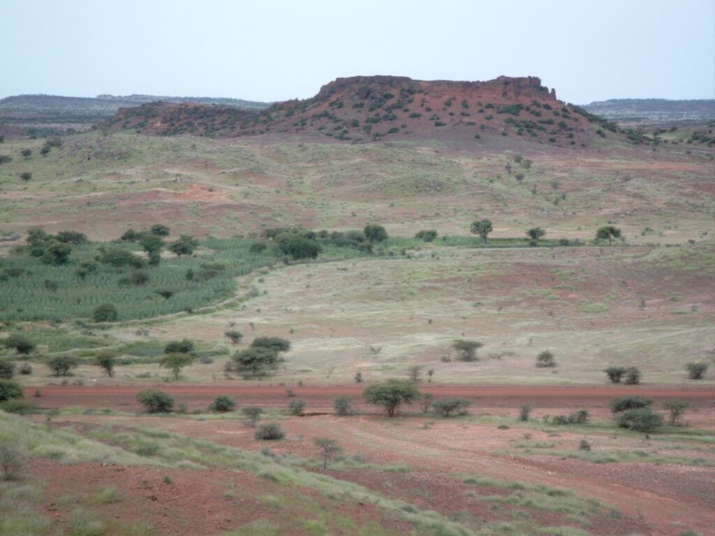
- Because reconstructing a planation surface therefore always combines several partially-independent lines of evidence rather than relying on one conclusive test, the identification of erosional surfaces remains as much a matter of disciplined, cross-checked inference as of direct observation — a methodological caution as relevant to reading a Deccan Trap-capped remnant in peninsular India as to any classic Davisian peneplain fragment described in the original literature.