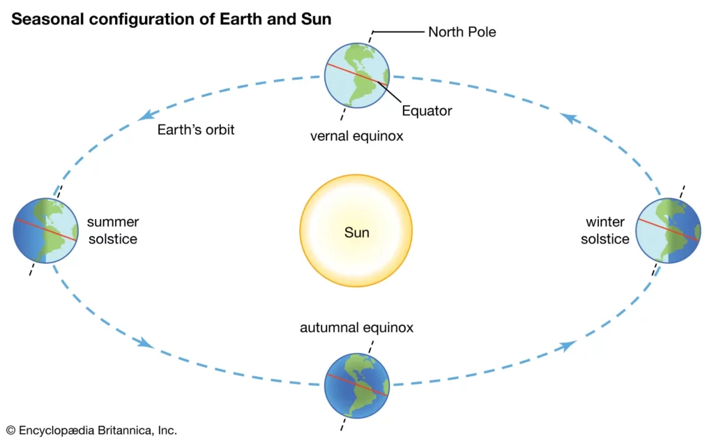
Q. On 21st June, the Sun
(a) does not set below the horizon at the Arctic Circle
(b) does not set below the horizon at Antarctic Circle
(c) shines vertically overhead at noon on the Equator
(d) shines vertically overhead at the Tropic of Capricorn
Answer: (a) does not set below the horizon at the Arctic Circle
Notes:
- Equinox:
- The whole earth experiences equal days and equal nights over equinox.
- It occurs on 21st March and September 23rd.
- At this position, direct rays of the sun fall on the equator.
- At this position, neither of the poles is tilted towards the sun i.e shines vertically overhead at noon on the Equator.
- Winter Solstice:
- It occurs on the 22nd of December.
- During the winter solstice, the nights are longer than the days.
- On 22nd December, the Tropic of Capricorn is tilted towards the sun and the sun does not set below the horizon at Antarctic Circle.
- As the sun’s rays fall vertically over the Tropic of Capricorn (23½° S), the Southern Hemisphere receives a major portion of the sun’s light.
- Summer Solstice:
- During Summer solstice, the days are longer than the nights.
- It occurs on the 21st of June in the northern hemisphere.
- On 21st June, the tropic of cancer is tilted towards the sun i.e the sun is always above the horizon and does not set below the horizon at the Arctic circle.
- After the Summer Solstice, the sun starts to sink towards the horizon.
- As the rays of the sun fall directly on the Tropic of Cancer, the northern hemisphere experience more heat.

Q. Consider the following pairs:
Famous place – River
1. Pandharpur – Chandrabhaga
2. Tiruchirappalli – Cauvery
3. Hampi – Malaprabha
Which of the pairs given above are correctly matched?
(a) 1 and 2 only
(b) 2 and 3 only
(c) 1 and 3 only
(d) 1, 2 and 3
Answer: (a) 1 and 2 only
Notes:
- Pandharpur:
- It is a city on the banks of Chandrabhaga River in Maharashtra.
- The famous Lord Vitthal-Rukmini Mandir is located in this city.
- Tiruchirappalli:
- It is situated on the banks of river Cauvery.
- It is a city in the Indian state of Tamil Nadu.
- The famous Sri Ranganathaswamy Temple is located in Tiruchirappalli.
- Hampi:
- It was the capital of the Vijayanagara kingdom and is located on the bank of the Tungabhadra River.
- Hampi is located in Karnataka.
- Many famous temples like Virupaksha Temple, Nandi Statue etc are located in Hampi.
- Pattadakal or Pattadakallu is situated on the banks of the river Malaprabha and is located in Karnataka.
Chandrabhaga River
- The Chandrabhaga River is one of the important rivers in Amaravati district of the state of Maharashtra.
- It is also the tributary of Purna River and forms a part of Tapti-Purna river system.
- The main stream of the river rises just down the Vairat plateau in the Chikhaldarahills and takes an eastward course draining the south slopes of Chikhaldara and Gawilgarh plateaus. There is a dam on the river as it comes out of the valley. The river takes a more southward turn from the dam and passes through the town of Daryapur before it meets with river Purna on the border of Amravati and Akola districts.
- Bhuleshwari is the main tributary of Chandrabhaga that meets it just before Daryapur. Bichan and Sapan rivers flowing through Paratwada and Achalpur are other affluent streams.
- This Chandrabhaga river is different from the Bhima river, which is popularly called as Chandrabhaga at Pandharpur.
Chandra and Bhaga River
- The River Chandra is one of the two rivers which merge to form the Chenab in the Lahaul region of Himachal Pradesh. It rises in the snows lying at the base of the main Himalayan range in the Lahaul and Spiti district. The beautiful Chandra Tal lake has formed at its source. It flows for a extensive distance along the base of this range in a southeasterly direction before turning completely and taking a southwesterly course in the Spiti Valley. It flows on to merge with the Bhaga River downstream of Keylong.
- The upper and middle catchments of this river are made up of a topography that has been carved out by glacial action. The whole area is a vast cold desert that receives little or no rain as it lies in the rain-shadow of the Pir Panjal range lying towards the south. Many small snow-fed tributaries join the Chandra at different places.
- Bhaga river joins Chandra river in Tandi to form Chandrabhaga and later Chenab which is one of the fastest flowing rivers of India. It originates near Baralacha la at around 16000 feet above sea level. From its source to its convergence with the Bhaga at Tandi, the Chandra registers a fall of about 12.5 metres per kilometre.
Must Read: Krishna River System
Q. Consider the following States:
- Chhattisgarh
- Madhya Pradesh
- Maharashtra
- Odisha
With reference to the States mentioned above, in terms of percentage of forest cover to the total area of State, which one of the following is the correct ascending order?
(a) 2-3-1-4
(b) 2-3-4-1
(c) 3-2-4-1
(d) 3-2-1-4
Answer: (c) 3-2-4-1
Notes:
- As per the report published by the Forest Survey of India the percentage of forested area in ascending order is:
- Chhattisgarh (41.09%),
- Odisha (32.98%),
- Madhya Pradesh (25.11%),
- Maharashtra (16.47%).
Forest Survey of India 2021
- The Total Forest and Tree cover is 24.62% of the geographical area of the country.
- The Total Forest cover is 7,13,789 sq km which is 21.71% of the geographical area of the country.
- The Tree cover is 2.91% of the geographical area of the country.
- As compared to ISFR 2019 the current assessment shows an increase of:
- 0.28% of forest and tree cover put together, at the national level.
- Forest Cover: 0.22%
- Tree Cover: 0.76%
- Change in Recorded forest Area/Green Wash (RFA/GW) as compared to previous assessment of 2019.
- Forest Cover within the RFA/GW: A slight increase of 31 sq km.
- Forest Cover outside the RFA/GW: There is an increase of 1,509 sq km.
- The top five states in terms of increase in forest cover:
- Andhra Pradesh>Telangana>Odisha>Karnataka>Jharkhand.
- Forest cover in the hill districts is 40.17% of the total geographical area of these districts. A decrease of 902 sq km (0.32%) in 140 hill districts of the country.
- The total forest cover in the tribal districts is 37.53% of the geographical area of these districts.
- The current assessment shows a decrease of 655 sq km of forest cover inside the RFA/GW in the tribal districts and an increase of 600 sq km outside.
- Total forest cover in the North-Eastern region is 64.66% of its geographical area. The current assessment shows a decrease of forest cover to the extent of 1,020 sq km (0.60%) in the region.
- Mangrove cover: The Mangrove cover in the country has increased by 0.34% as compared to the previous assessment.
- Total Carbon Stock: The total carbon stock in forests is estimated as 7,204.0 million tonnes an increase of 79.4 million tonnes since 2019.
- Forest Prone to Fire: The analysis reveals that 22.27% of the forest cover is prone to forest fire.
- Bamboo Forests: The total bamboo bearing area of the country is estimated as 1,49,443 sq km. There is a decrease of 10,594 sq km in the bamboo bearing area as compared to the estimate of ISFR 2019.
Q. Consider the following pairs:
Sea – Bordering Country
- Adriatic Sea – Albania
- Black Sea – Croatia
- Caspian Sea – Kazakhstan
- Mediterranean Sea – Morocco
- Red Sea – Syria
Which of the pairs given above are correctly matched?
(a) 1, 2 and 4 only
(b) 1, 3 and 4 only
(c) 2 and 5 only
(d) 1, 2, 3, 4 and 5
Answer: (b) 1, 3 and 4 only
Notes:
- The Adriatic Sea is a body of water separating the Italian Peninsula from the Balkan peninsula. The countries with coasts on the Adriatic sea are Albania, Bosnia and Herzegovina, Croatia, Italy, Montenegro and Slovenia.
- Black Sea is a large inland sea situated at the southeastern extremity of Europe. It is bordered by Ukraine to the north, Russia to the northeast, Georgia to the east, Turkey to the south, and Bulgaria and Romania to the west. Black Sea is not bordered by Croatia.
- Caspian Sea is the world’s largest inland body of water, variously classed as the world’s largest lake or a full-fledged sea.
- It is an endorheic basin (a basin without outflows) located between Europe and Asia.
- It is bounded by Kazakhstan to the northeast, Russia to the northwest, Azerbaijan to the west, Iran to the south, and Turkmenistan to the southeast.
- Mediterranean Sea is an intercontinental sea that stretches from the Atlantic Ocean on the west to Asia on the east and separates Europe from Africa.
- The countries surrounding the Mediterranean in clockwise order are Spain, France, Monaco, Italy, Slovenia, Croatia, Bosnia and Herzegovina, Montenegro, Albania, Greece, Turkey, Syria, Lebanon, Israel, Egypt, Libya, Tunisia, Algeria, and Morocco.
- Red Sea is a narrow strip of water extending south-eastward from Suez, Egypt, for about 1,930 km to the Bab-el-Mandeb Strait, which connects with the Gulf of Aden and thence with the Arabian Sea.
- The six countries bordering the Red Sea proper are – Saudi Arabia, Yemen, Egypt, Sudan, Eritrea and Djibouti. Red Sea is not bordered by Syria.
Must Read: Important Seas of the world
Q. Consider the following pairs
Glacier – River
- Bandarpunch – Yamuna
- Bara Shigri – Chenab
- Milam – Mandakini
- Siachen – Nubra
- Zemu – Manas
Which of the pairs correctly matched?
(a) 1, 2 and 4
(b) 1, 3 and 4
(c) 2 and 5
(d) 3 and 5
Answer: (a) 1, 2 and 4
Notes:
- Bandarpunch is a mountain massif of the Garhwal division of the Himalayas, in the Indian state of Uttarakhand.
- It is part of the Sankari Range and lies within the Govind Pashu Vihar National Park and Sanctuary.
- It is a source of the Yamuna river, whose source lies above Yamnotri, on the west end of the massif below White Peak.
- Bara-Shigri glacier which is the second longest glacier in Himalaya after Gangotri, is located in the Chandra valley of Lahaul.
- The name comes from the Lahaul dialect, where Bara means big and Shigri means glacier.
- The glacier feeds the Chenab river.
- Milam glacier is a major glacier of the Kumaon Himalaya.
- It is a part of the Pithoragarh district of Uttarakhand, India, about 15 kilometres northeast of Nanda Devi.
- The glacier is the source of the Goriganga River.
- Mandakini river is a tributary of the Alaknanda river which originates from the Chorabari glacier near Kedarnath in Uttarakhand, India.
- Mandakini is fed by Vasukiganga river at Sonprayag. Mandakini joins Alaknanda at Rudraprayag.
- Alaknanda then proceeds towards Devaprayag where it joins Bhagirathi River to form the Ganges River.
- Mandakini river flows along NH-107 in Rudraprayag district and turns violent during monsoon, often destroying parts of the highway and adjoining villages.
- Siachen glacier is located in the eastern Karakoram range in the Himalayas just northeast of the point NJ9842 where the LOC between India and Pakistan ends.
- The glacier’s melting waters are the main source of the Nubra River in the Indian region of Ladakh, which drains into the Shyok River.
- The Shyok in turn joins the 3000 kilometre-long Indus River which flows through Pakistan.
- Zemu glacier is the largest glacier in the Eastern Himalaya.
- It is located at the base of Kangchenjunga in the Himalayan region of Sikkim, India.
- The Zemu glacier drains the east side of Kanchenjunga, the world’s third highest mountain.
- The glacier is the source of water for numerous rivers, as it feeds them when it melts. One of them is the Teesta river.
- Manas river is a transboundary river in the Himalayan foothills between southern Bhutan and India.
- It is the largest river system of Bhutan.
- The total length of the river is 400 kilometres which flows through Tibet, China for 24 km, flows in Bhutan for 272 kilometres and then flows through Assam for 104 kilometres before it joins the mighty Brahmaputra River at Jogighopa.
Must Read: Important Glaciers in India
Q. Why are dewdrops not formed on a cloudy night?
(a) Clouds absorb the radiation released from the Earth’s surface.
(b) Clouds reflect back the Earth’s radiation.
(c) The Earth’s surface would have low temperature on cloudy nights.
(d) Clouds deflect the blowing wind to ground level.
Answer: (b) Clouds reflect back the Earth’s radiation.
Notes:
- When the moisture is deposited in the form of water droplets on cooler surfaces of solid objects (rather than nuclei in air above the surface) such as stones, grass blades and plant leaves, it is known as dew.
- The ideal conditions for its formation are
- clear sky,
- calm air,
- high relative humidity, and
- cold and long night
- For the formation of dew, it is necessary that the dew point is above the freezing point.
- When the sky is clear and the trees and plants are cooler at nights, there is more evaporation of water and hence more dew formation.
- But when sky is cloudy, the trees and plants do not get cool in the night and hence there is less dew formation because on a cloudy night, the clouds send the heat (earth’s radiation) back to the ground so the ground never gets cold enough for the dew to be formed.
Q. Consider the following statements about Particularly Vulnerable Tribal Groups (PVTGs) in India:
- PVTGs reside in 18 States and one Union Territory.
- A stagnant or declining population is one of the criteria for determining PVTG status.
- There are 95 PVTGs officially notified in the country so far.
- Irular and Konda Reddi tribes are included in the list of PVTGs.
Which of the statements given above are correct?
(a) 1, 2 and 3
(b) 2, 3 and 4
(c) 1, 2 and 4
(d) 1, 3 and 4
Answer: (c) 1, 2 and 4
PVTGs
- Particularly Vulnerable Tribal Groups (PVTGs) are centrally recognized special category from among the Scheduled Tribe.
- It was constituted during the 4th five year plan on the basis of the report of the Dhebar commission (1960-61).
- Such groups were identified by one or more of the following features:
- Pre-agricultural level of technology,
- Low level of literacy,
- Economic backwardness,
- A declining or stagnant population.
- There are total 75 tribal groups have been categorized categorized by Ministry of Home Affairs as Particularly Vulnerable Tribal Groups (PVTG)s.
- PVTGs reside in 18 States and UT of A&N Islands. Hence, statement 1 is correct.
- Konda reddy of Khammam district of Telangana and Irular of Tamil Nadu are in the list of PVTGs.
- Besides a number of schemes of Government of India and the State Governments where PVTG population are also benefitted along with other population, Ministry of Tribal Affairs administers a scheme namely ‘Development of Particularly Vulnerable Tribal Groups (PVTG)’ specifically for the PVTG population.
- Under this scheme, financial assistance is provided to the State/UT Governments based on their proposals for development of tribal people under various sectors.
- The projects taken up under this scheme are demand driven.
Must Read: Important Tribes of India
Q. Consider the following statements:
- As per the recent amendment to the Indian Forest Act, 1927, forest dwellers have the right to fell the bamboos grown on forest areas.
- As per the Scheduled Tribes and Other Traditional Forest Dwellers (Recognition of Forest Rights) Act, 2006, bamboo is a minor forest produce.
- The Scheduled Tribes and Other Traditional Forest Dwellers (Recognition of Forest Rights) Act, 2006 allows ownership of minor forest produce to forest dwellers.
Which of the statements given above is/are correct?
(a) 1 and 2 only
(b) 2 and 3 only
(c) 3 only
(d) 1, 2 and 3
Answer: (b) 2 and 3 only
Notes:
- The Indian Forest (Amendment) Bill 2018 permits felling and transit of bamboo grown in non-forest areas.
- However, bamboo grown on forest lands would continue to be classified as a tree and would be guided by the existing legal restrictions.
- The Forest Rights Act (FRA) of 2006 recognises bamboo as an Minor Forest Produce
- It vests the “right of ownership, access to collect, use and dispose of minor forest produce” with Scheduled Tribes and traditional forest dwellers.
- In 2006, the Forest Rights Act (FRA) for the first time defined minor forest produce as including bamboo and tendu and many other things.
- It also gave tribals and other traditional forest dwellers the “right of ownership, access to collect, use and dispose of minor forest produce, which has been traditionally collected within or outside village boundaries.”
Q. With reference to the management of minor minerals in India, consider the following statements:
- Sand is a ‘minor mineral’ according to the prevailing law in the country.
- State Governments have the power to grant mining leases of minor minerals, but the powers regarding the formation of rules related to the grant of minor minerals lie with the Central Government.
- Stale Governments have the power to frame rules to prevent illegal mining of minor minerals.
Which of the statements given above is/are correct?
(a) 1 and 3 only
(b) 2 and 3 only
(c) 3 only
(d) 1, 2 and 3
Answer: (a) 1 and 3 only
Notes:
- Sand is a minor mineral, as defined under section 3 (e) of the Mines and Minerals (Development and Regulation) Act, 1957 (MMDR Act).
- Section 15 of the MMDR Act empowers state governments to make rules for regulating the grant of mineral concessions in respect of minor minerals and for purposes connected therewith.
- The regulation of grant of mineral concessions for minor minerals is, therefore, within the legislative and administrative domain of the state governments.
- Under the power granted to them by section 15 of the MMDR Act, State Governments have framed their own minor minerals concession rules.
- Section 23C of the MMDR Act, 1957 empowers state governments to frame rules to prevent illegal mining, transportation and storage of minerals and for purposes connected therewith.
- Control of illegal mining is, therefore, under the legislative and administrative jurisdiction of state governments.
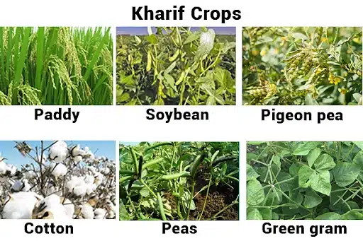
Q. With reference to the cultivation of Kharif crops in India in the last five years, consider the following statements:
- Area under rice cultivation is the highest.
- Area under the cultivation of jowar is more than that of oilseeds.
- Area of cotton cultivation is more than that of sugarcane.
- Area under sugarcane cultivation has steadily decreased.
Which of the statements given above are correct?
(a) 1 and 3 only
(b) 2, 3 and 4 only
(c) 2 and 4 only
(d) 1, 2, 3 and 4
Answer: (a) 1 and 3 only
Notes:
- The area under rice cultivation in India, in 2013-14 was 44.13 million hectares while in 2015-16, it became 43.39 million hectares and is highest amongst all.
- The annual area under Jowar ranges between 17 and 18 million hectares while the oilseed area is 28 million hectares (2013-14), 26.1 million hectares (2015-16) i.e area under the cultivation of Jowar is less than that of oilseeds.
- The area under sugarcane cultivation has not steadily decreased. The area under sugarcane cultivation 4.99 million hectares (2013-14), 5.066 million hectares (2014-15), 4.953 million hectares (2015-16).
- The area under cotton cultivation is 11.96 million hectares (2013-14), 12.81 million hectares (2014-15), and 11.87 million hectares (2015- 16). Hence the area under cotton cultivation is more than sugar cultivation.

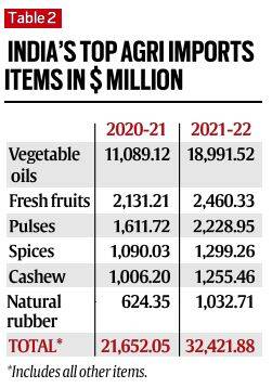
Q. Among the agricultural commodities imported by India, which one of the following accounts for the highest imports in terms of value in the last five years?
(a) Spices
(b) Fresh fruits
(c) Pulses
(d) Vegetable oils
Answer: (d) Vegetable oils
Notes:
- Vegetable oils account for the highest import in terms of value in the last five years.
- India relies on imports for 70 percent of its edible oil consumption.
- The HIghest import of vegetable oils in terms of value is in December 2018 in the last five years.
- Pulses account for second-most highest while fresh fruits account for third-highest and spices account for least imports in terms of value in the last five years among the following agricultural commodities imported by India.

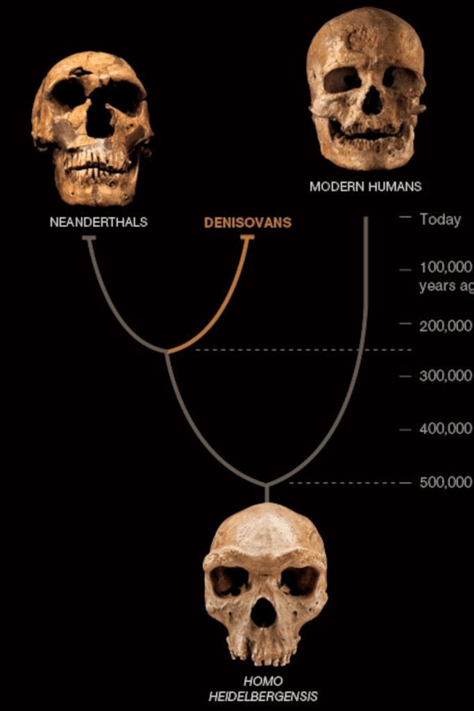
Q. The word ‘Denisovan’ is sometimes mentioned in media in reference to
(a) fossils of a kind of dinosaurs
(b) an early human species
(c) a cave system found in North-East India
(d) a geological period in the history of Indian subcontinent
Answer: (b) an early human species
Notes:
- Denisovans are an extinct species of hominid.
- Fossil evidence of the Denisovans first identified in 2010.
- The jawbone discovered in the Tibetan Plateau and dated to more than 160,000 years ago, is the first Denisovan fossil found outside the Siberian cave.

