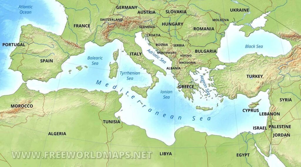
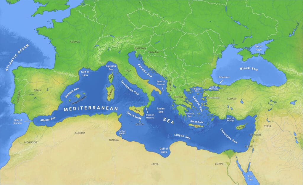
Q. Which one of the following countries of South-West Asia does not open out to the Mediterranean Sea?
(a) Syria
(b) Jordan
(c) Lebanon
(d) Israel
Answer: (b) Jordan
Mediterranean Sea
- The Mediterranean Sea is the intercontinental sea that separates Europe from Africa.
- Mediterranean Sea is a sea connected to the Atlantic Ocean, surrounded by the Mediterranean Basin and almost completely enclosed by land: on the north by Southern Europe and Anatolia, on the south by North Africa, and on the east by the Levant in Western Asia.
- The countries bordered the Mediterranean sea are Albania, Algeria, Bosnia and Herzegovina, Croatia, Cyprus, Egypt, France, Greece, Israel, Italy, Lebanon, Libya, Malta, Monaco, Montenegro, Morocco, Slovenia, Spain, Syria, Tunisia, and Turkey.
- Jordan does not open out to the Mediterranean sea, as it is bounded by Syria and Israel towards the side of the Mediterranean sea.
Q. “Each day is more or less the same, the morning is clear and bright with a sea breeze; as the Sun climbs high in the sky, heat mounts up, dark clouds form, then the rain comes with thunder and lightning. But the rain is soon over”. Which of the following regions is described in the above passage?
(a) Savannah
(b) Equatorial
(c) Monsoon
(d) Mediterranean
Answer: (b) Equatorial
Equatorial climate
- Rainforests are located in the equatorial climate region.
- They are hot and wet all year-round with a humid climate.
- The temperatures are constant throughout the year with little variation.
- The annual rainfall is high as it rains almost every day.
- Equatorial type of climate is found in the Amazon basin in South America, Congo basin in Africa, Guinea coast in Africa, and much of the Indo-Malaysian region, eastern Central America, some islands in the Caribbean Sea, western Colombia, and eastern Madagascar.
- This type of climate is located till 5 degrees to 10 degrees on either side of the equator.
Warm Temperate Western Margin Climate
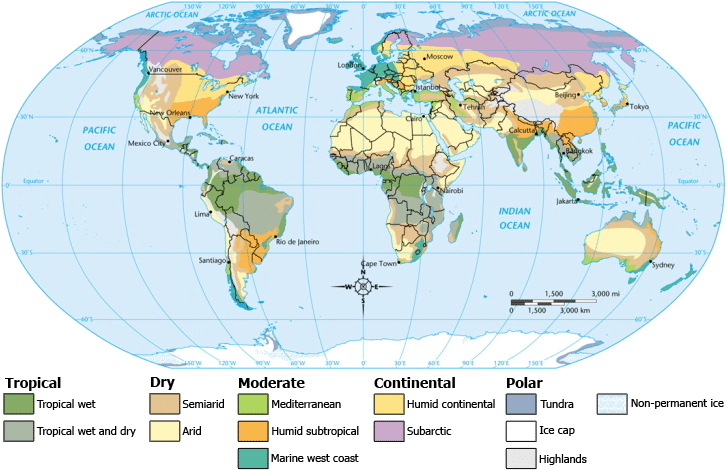
- It is also called a Mediterranean type of climate because most of the areas falling under this climate are situated around the Mediterranean Sea.
- This climate has developed between 300C and 450C latitudes in both the hemispheres in the western part of the continents.
- The climate of Central Chile is of temperate Mediterranean type of climate.
- This climate region includes Southern Italy, Greece, Western Turkey, Syria, Lebanon, Western Israel, North Coastal Africa, central and Southern California in the USA, Central Chile in South America, Cape Town area in South Africa, and the coastal zones of Southern and Southwest Australia.
- Summers are warm and bright and winters are mild and cool.
Monsoon type of climate
- It is best developed in the Indian subcontinent, Myanmar, Thailand, Laos, Cambodia, parts of Vietnam, and south china and northern Australis.
- This type of climate is characterized by the onshore wet monsoon in summer and offshore dry monsoon in winter.
- The basic cause of monsoon climates is the difference in the rate of heating and cooling of land and sea.
Sudan or Savannah Climate
- It is a transitional type of climate found between the equatorial forests and the trade wind hot deserts.
- It is confined within the tropics and is best developed in Sudan in the Africa Continent.
- Sudan Climate includes West Africa Sudan, East Africa, and southern Africa north of the Tropic of Capricorn.
- In South America, there are two distinct regions of savanna north and south of the equator, namely the llanos of the Orinoco basin and the campus of the Brazilian Highlands.
- The Australian Savanna is located south of the monsoon strip and north of the Tropic of Capricorn.
- It is characterized by high temperatures throughout the year ranging between 240C and 270C.
Must Read: Climatic Regions of World
Q. In the South Atlantic and South-Eastern Pacific regions in tropical latitudes, cyclone does not originate. What is the reason?
(a) Sea surface temperatures are low
(b) Inter-Tropical Convergence Zone seldom occurs
(c) Coriolis force is too weak
(d) Absence of land in those regions
Answer: (b) Inter-Tropical Convergence Zone seldom occurs
Reasons for the lack of cyclone formation in the South Atlantic
- Sea surface temperatures run a shade cooler than the one ideal for tropical cyclone formation.
- Climatologically high values of vertical wind shear across that basin throughout the year even in summer.
- Vorticity: Lack of pre-existing centres of rotation in the area.
- Absence of tropical waves.
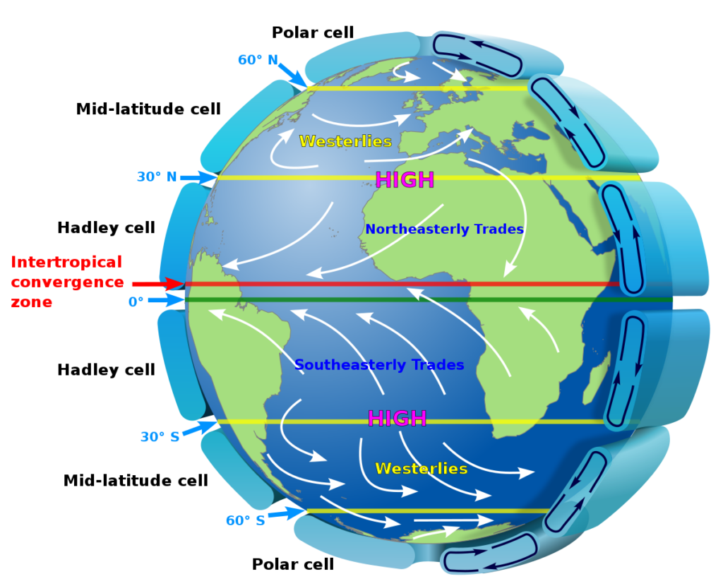
- The Intertropical Convergence Zone (ITZC), which shifts toward the north in northern summer and toward the south in the southern summer, usually stays at or north of the equator.
- The tropospheric vertical wind shear is much too strong and there is typically no inter-tropical convergence zone (ITCZ) over the ocean.
- Without an ITCZ to provide synoptic vorticity and convergence resulting in large-scale spin and thunderstorm activity as well as having strong wind shear, it becomes very difficult to generate tropical cyclones.
- ITCZ stays at or near the equator and does not shift southward over the south Atlantic or South Pacific region. Therefore, these regions do not have the ITCZ over them which is a major cause of the lack of cyclones.
- Lower sea temperatures are also a reason.
Q. What explains the eastward flow of the equatorial counter-current?
(a) The Earth’s rotation on its axis
(b) Convergence of the two equatorial currents
(c) Difference in salinity of water
(d) Occurrence of the belt of calm near the equator
Answer: (b) Convergence of the two equatorial currents
Notes:
- The equatorial countercurrents are driven by a distinct surface wind pattern in the tropics.
- Strong westward trade winds result in westward surface flow in most of the tropical Atlantic and Pacific Oceans.
- However, several hundred mi. (km.) north of the equator, the winds are much weaker, in comparison
- The stronger winds to the south pile up water where the winds are weak.
- As a result, the surface of the ocean can be up to 6 in. (15 cm.) higher and the thermocline as much as 328 ft. (100 m.) deeper than it is directly to the north.
- The excess water flows eastward under the influence of the Earth’s rotation, giving rise to the equatorial countercurrents.
- In the Indian Ocean, the equatorial countercurrent is located several hundred mi. (km.) south of the equator.
- In all three oceans, the equatorial countercurrent is concentrated in the upper 656 ft. (200 m.), above the thermocline.
- The intensity of the equatorial countercurrent varies from season to season and from month to month.
- The strongest seasonal changes occur in the Atlantic Ocean.
- Eastward flow reaches a maximum in the summer and fall, with speeds of up to 12 in. (30 cm.) per second, and disappears in the spring.
- Seasonal changes are weaker in the Pacific Ocean. Here, the equatorial countercurrent exists year-round, and is strongest in the fall and winter, with speeds slightly
Q. Tides occur in the oceans and seas due to which among the following
- Gravitational force of the Sun
- Gravitational force of the Moon
- Centrifugal force of the Earth
Select the correct answer using the codes given below.
(a) 1 only
(b) 2 and 3 only
(c) 1 and 3 only
(d) 1, 2 and 3
Answer: (d) 1, 2 and 3
Notes:
- The periodical rise and fall of the sea level is known as tide.
- The Moon’s gravitational pull is the major cause of a tide.
- Sun’s gravitational pull and centrifugal force due to the gravitational pull of the earth to a lesser extent so causes types.
- The movement of water is caused by Meteorological effects like winds and atmospheric pressure change and is known as surges.
- The tide-generating force is the difference between the gravitational attraction of the Moon and the centrifugal force.
- Tides vary in frequency, direction, and movement from place to place and from time to time.
- Based on frequency, they are classified into the semi-diurnal, diurnal, and mixed tide.
- Springtide: when the sun, moon, and earth are in a straight line the height of the tide is higher and this occurs on a full moon period.
- Neap tide: when the moon and the sun are at right angles to each other the forces of the sun and the moon tend to counteract each other. It occurs twice a month.
Q. Which one of the following pairs of States of India indicates the easternmost and westernmost State?
(a) Assam and Rajasthan
(b) Arunachal Pradesh and Rajasthan
(c) Assam and Gujarat
(d) Arunachal Pradesh and Gujarat
Answer: (d) Arunachal Pradesh and Gujarat
Notes:
- India is a vast country lying entirely in the Northern hemisphere & the main land extends between latitudes (parallels) 8°4’N and 37°6’N and longitudes (meridians) 68°7’E and 97°25’E.
- The easternmost longitude 97°25’E lies in the state of Arunachal Pradesh making it the easternmost state of India.
- While the westernmost longitude 68°7’E lies in the state of Gujarat making it the westernmost state of India.
Q. Consider the following pairs:
Place of Pilgrimage Location
- Srisailam : Nallamala Hills
- Omkareshwar : Satmala Hills
- Pushkar : Mahadeo Hills
Which of the above pairs is/are correctly matched?
(a) 1 only
(b) 2 and 3 only
(c) 1 and 3 only
(d) 1, 2 and 3
Answer: (a) 1 only
Srisailam:
- Srisailam is the shrine of Lord Mallikarjuna on the flat top of Nallamala Hills in Andhra Pradesh.
- Sri Bhramaramba Mallikarjuna Temple or Srisailam Temple is a Hindu temple dedicated to the deities Shiva and Parvati.
- This temple is one of the twelve Jyotirlingas of Lord Shiva and one of the eighteen Shakti Peethas of goddess Parvati.
- Shiva is worshipped as Mallikarjuna and is represented by the lingam.
- Parvati is depicted as Bhramaramba.
Omkareshwar:
- Omkareshwar is situated on the Mandhata hills in Madhya Pradesh (ancient name: Shivpuri).
- River Narmada flows here around the Mandhata hill in the form of an Om which gives it the name, ‘Omkareshwar‘.
- Omkareshwar is a Hindu temple dedicated to God Shiva.
- It is one of the 12 revered Jyotirlinga shrines of Shiva.
Pushkar:
- The Mahadeo Hills are a range of hills in Madhya Pradesh state of central India.
- Pushkar lies in Ajmer, Rajasthan.
- Pushkar is famous for the red spired Brahma Temple
- Pushkar is located on the shore of Pushkar Lake.
Q. Consider the following rivers:
- Vamsadhara
- Indravati
- Pranahita
- Pennar
Which of the above are tributaries of Godavari?
(a) 1, 2 and 3
(b) 2, 3 and 4
(c) 1, 2 and 4
(d) 2 and 3 only
Answer: (d) 2 and 3 only
River Godavari
- The Godavari river is the largest river of Peninsular India.
- It is also called Dakshin Ganga.
- It covers the state of Maharastra, Telangana, Andhra Pradesh, Chhattisgarh, Odisha and parts of Madhya Pradesh, Karnataka and Union Territory of Puducherry (Yanam) having a total area of ~ 3 lakh Sq.km.
- The Godavari River rises from Trimbakeshwar in the Nashik district of Maharashtra.
- Left Bank Tributaries:
- Dharna, Penganga, Wainganga, Wardha, Pranahita, Pench, Kanhan, Sabari, Indravati etc.
- Right Bank Tributaries:
- Pravara, Mula, Manjra, Peddavagu, Maner etc.
Vamshadhara
- River Banshadhara is an important east-flowing river between Rushikulya and Godavari, in Odisha and Andhra Pradesh.
- The river originates in the border of Thuamul Rampur in the Kalahandi district and Kalyansinghpur in Rayagada district of Odisha
- It runs for a distance of about 254 kilometres, where it joins the Bay of Bengal at Kalingapatnam, Andhra Pradesh.
Pennar
- The Pennar rises in the Chenna Kasava hill of the Nandidurg range, in Chikkaballapura district of Karnataka and flows towards east eventually draining into the Bay of Bengal.
- The total length of the river from origin to its outfall in the Bay of Bengal is 597 km.
- The Pennar basin extends over states of Andhra Pradesh and Karnataka having an area of ~55 thousand Sq.km.
Q. Which one of the following regions of India has a combination of mangrove forest, evergreen forest, and deciduous forest?
(a) North Coastal Andhra Pradesh
(b) South-West Bengal
(c) Southern Saurashtra
(d) Andaman and Nicobar Islands
Answer: (d) Andaman and Nicobar Islands
Notes:
- The epiphytic vegetation, mostly ferns, and orchids are found in South Andaman forests.
- Moist deciduous forests are found in the Middle Andamans.
- North Andamans is characterized by the wet evergreen type, with plenty of woody climbers.
- The North Nicobar Islands (including Car Nicobar and Battimalv) are marked by the complete absence of evergreen forests, while such forests form the dominant vegetation in the central and southern islands of the Nicobar group.
- Grasslands occur only in the Nicobars, and while deciduous forests are common in the Andamans.
- The present forest coverage is claimed to be 86.2% of the total land area.
- This atypical forest coverage is made-up of twelve types namely (1) Giant evergreen forest (2) Andamans tropical evergreen forest (3) Southern hilltop tropical evergreen forest (4) Cane brakes (5) Wet bamboo brakes (6) Andamans semi-evergreen forest (7) Andamans moist deciduous forest (8) Andamans secondary moist deciduous forest (9) Littoral forest (10) Mangrove forest (11) Brackish water mixed forest (12) Submontane hill valley swamp forest.
Q. Which one of the following National Parks has a climate that varies from tropical to subtropical, temperate, and arctic?
(a) Khangchendzonga National Park
(b) Nadadevi National Park
(c) Neora Valley National Park
(d) Namdapha National Park
Answer: (d) Namdapha National Park
Namdapha National Park
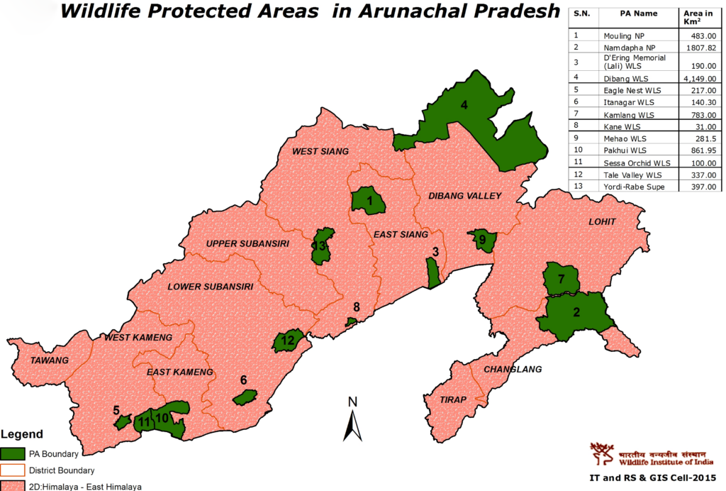
- In 1972, Namdapha was designated as a wildlife sanctuary. In 1983, it was designated as a tiger reserve and a national park. It is on the tentative list of UNESCO World Heritage Sites in India.
- It is the easternmost biodiversity hotspot in the eastern Himalayas with over 1400 faunal species and 1000 floral species.
- There are altitudinal variations which can range from 200 m to 4500 m at Dapha Bum – the highest point.
- It is the only park in the world to have four feline species of big cat namely – tiger (Panthera tigris), leopard (Panthera pardus), clouded leopard (Neofelis nebulosa) and snow leopard (Panthera uncia) and a number of lesser cats.
- The region is very rich in Lepidoptera species. Both butterflies and moths are in equal abundance.
- A number of primate species are seen in the park, such as the Assamese macaque, pig-tailed macaque, stump-tailed macaque and a number of the distinctive Hoolock Gibbons (Hylobates Hoolock), a highly endangered and the only ‘ape’ species found in India dwells in this impenetrable virgin forest.
- Of the many other important animals are the elephants, black bears, Indian Bison, several species of deer, reptiles and a variety of arboreal animals.
- The park has more than 425 bird species. There are five species of hornbills recorded from the area.
- There are more than 150 timber species. The Pinus merkusii and Abies delavavi are not found elsewhere in India.
- One of the rarest and endangered orchids, the Blue Vanda is found here.
- The most famous local medicinal plant Mishimi Teeta (Copti teeta), which is used by the local tribe for various diseases is available here but its export has been banned.
Neora Valley National Park
- It is located on the Himalayas in Kalimpong district, West Bengal.
- It is the land of Red Panda (EN).
- Vegetation: Himalayan Broadleaf forests.
- Major Flora: Rhododendron, bamboo, oak, ferns, sal.
- Major Fauna: Indian leopard, black bear, sloth bear, golden cat, barking dee, Himalayan flying squirrel, thar.
- It is linked to Pangolakha Wildlife Sanctuary of Pakyong District as well as forests of Samtse District, Bhutan via thick cover of forests.
Nadadevi National Park
- Nanda Devi National Park or Nanda Devi Biosphere Reserve, established in 1982 is a national park situated around the peak of Nanda Devi (7816 m) in Chamoli Garhwal district of Uttarakhand.
- National Park was inscribed a World Heritage Site by UNESCO in 1988. It was later expanded and renamed as Nanda Devi and Valley of Flowers National Parks in 2005. Together they encompass a unique transition zone between the mountain ranges of the Zanskar and Great Himalaya.
- Seven endangered mammal species find refuge in the area such as the snow leopard (Panthera unica), Himalayan black bear (Selenarctos thibetanus), brown bear (Ursus arctos), musk deer (Moschus chrysogaster) and bharal/blue sheep (Pseudois nayaur).
Khangchendzonga National Park
- Khangchendzonga Biosphere Reserve which is located in Sikkim is one of the highest ecosystems in the world, reaching elevations of 1, 220 metres above sea-level.
- It includes a range of ecoclines (a gradation from one ecosystem to another, with no abrupt boundary between the two), varying from sub-tropic to Arctic, as well as natural forests in different biomes, that support an immensely rich diversity of forest types and habitats.
- Khangchendzonga National Park (KNP) was designated a World Heritage Site in 2016 under the ‘mixed’ category (Mixed heritage sites contain elements of both natural and cultural significance).
- World’s third highest peak, Mt. Khangchendzonga, is situated within the Park. Numerous lakes and glaciers, including the 26 km long Zemu Glacier are a part of the Biosphere reserve.
- Many of the mountains, peaks, lakes, caves, rocks, Stupas (shrines) and hot springs function as pilgrimage sites.
- Over 118 species of the large number of medicinal plants found in Dzongu Valley in north Sikkim are of ethno-medical utility.
- The transition zone of the Biosphere Reserve is targeted for eco-development activities, afforestation, plantation of medicinal herbs and soil conservation measures.
- The core area of the Biosphere Reserve is a major transboundary Wildlife Protected Area and is largely situated in the Greater Himalayas.
- The northern part of the area is characterized by trans-Himalayan features.
- Buffer zones are being developed in the Park to promote eco-tourism activities.
- The six cat species confirmed to have been found are:
- Leopard
- Clouded Leopard
- Snow Leopard
- Jungle Cat
- Golden Cat
- Leopard Cat
Q. Consider the following States:
- Arunachal Pradesh
- Himachal Pradesh
- Mizoram
In which of the above States do ‘Tropical Wet Evergreen Forests’ occur?
(a) 1 only
(b) 2 and 3 only
(c) 1 and 3 only
(d) 1, 2 and 3
Answer: (c) 1 and 3 only
Tropical Evergreen Forest
- The tropical wet evergreen forest in India is usually found in areas receiving more than 200 cm of rainfall and having a temperature of 15-30 degrees Celsius.
- They occupy about 7% of the earth’s surface.
- They are found mostly near the equator.
- They have sparse undergrowth interspersed with clearings
- They have a scarce presence of litter (organic matter settling on the ground)
- These forests are dense and multi-layered.
- In tropical evergreen forest trees remain green throughout the year.
- There is no definite time for trees to shed their leaves, flower, and fruition.
- They are classified into tropical wet (moist) evergreen, Semi-evergreen, and Dry evergreen.
Tropical Wet Evergreen forest:
- In India, evergreen forests are found on the eastern and western slopes of the Western Ghats in such states like Tamil Nadu, Karnataka, Kerala and Maharashtra. And also found in Assam, Arunachal Pradesh, Meghalaya, Nagaland, Tripura, West Bengal and Andaman and Nicobar Islands.
- They are found in hot and humid areas.
- Precipitation: >250 cm
- Mean annual temperature <25 degree Celsius
- Humidity >80%
- Tropical evergreen forests are well stratified, with layers closer to the ground covered with shrubs and creepers, followed by short structured trees and a tall variety of trees.
- Trees can reach up to a height of 60m or above.
- They are rich in biodiversity (Rich in flora and fauna).
- Fine-grained and durable timber is produced in these forests.
- Important Species found in these forests: Rosewood, Mahogany, Aini, Ebony, Mesa, White cedar, Jamun, Canes, Gurjan, Agar, Bamboo, etc.
- The common animals found in these forests are elephants, monkeys, lemur, and deer.
- The one-horned rhinoceros are found in the jungles of Assam and West Bengal. Birds, bats, sloths, scorpions, and snails are also found in these jungles.
Q. Consider the following statements:
- The winds which blow between 30°N and 60°S latitude throughout the year are known as westerlies.
- The moist air masses that cause winter rains in North-Western region of India are part of westerlies.
Which of the statements given above is/are correct?
(a) 1 only
(b) 2 only
(c) Both 1 and 2
(d) Neither 1 nor 2
Answer: (b) 2 only
Notes:
- Westerlies and Easterlies are examples of Planetary winds or Primary winds. These are the winds that typically blow in the same direction all year.
- Westerlies are prevailing winds that flow from the west towards the East.
- It flows between 30°N-60°N and 30°S-60°S degrees latitude.
- It is also known as anti trades winds as it originates from the high-pressure area Horse latitude and flows towards the subpolar low-pressure area.
- The blows from South West to North East in the Northern hemisphere and from North west to the south east in the southern hemisphere.
- The westerlies are stronger in the Southern hemisphere due to the vast ocean and comparatively less land.
- They are best observed between 40 to 60-degree latitude and these latitudes are also known as Roaring forties, Furious fifties, and shrieking sixties.
- There are fluctuations in the subpolar region. Thus, they produce wet spells due to variation in weather.
- The moist air masses that cause winter rains in the North-Western region of India part of Western disturbances that originate from the Mediterranean sea.
Q. In India, in which one of the following types of forests is teak a dominant tree species?
(a) Tropical moist deciduous forest
(b) Tropical rain forest
(c) Tropical thorn scrub forest
(d) Temperate forest with grasslands
Answer: (a) Tropical moist deciduous forest
Notes:
- Deciduous forest, vegetation composed primarily of broad-leaved trees that shed all their leaves during one season.
- Teak is the most dominant species of tropical deciduous forests.
- Tropical deciduous forests are also known as “Monsoon” forests.
- They spread over regions that receive rainfall between 70-200 cm.
- The humidity in these forests lie in the range of 80-90 per cent.
- Trees of this forest type shed their leaves for about six to eight weeks in dry summers.
- These forests are found in the north-eastern states along the foothills of the Himalayas, eastern slopes of the Western Ghats, and Orissa.
- Major states where tropical deciduous forests are found:
- Madhya Pradesh
- Uttar Pradesh
- Chattisgarh
- Odisha
- Maharashtra (Some Parts)
- Major states where tropical deciduous forests are found:
- Teak, sal, shisham, hurra, mahua, amla, semul, Kusum, and sandalwood, etc. are the main species of these forests.
| Dry Deciduous Forest | Moist Deciduous Forests |
|---|---|
| These forests are found throughout the northern part of India and also in Karnataka, Tamil Nadu, Gujarat, Madhya Pradesh and Andhra Pradesh. | These forests are found almost throughout India except in the western and north-western part of India. |
| They are present in areas where the annual rainfall ranges from 70 cm to 100 cm. | They occur in areas where the annual precipitation ranges from 10 cm to 200 cm. |
| Teak, Sal and Peepal are some of the dominant species of trees in these forests. | Shisham, Sal, Teak, Mango and Rosewood are some of the dominant species of trees in these forests. |
