Q. Consider the following statements :
- Jhelum River passes through Wular Lake.
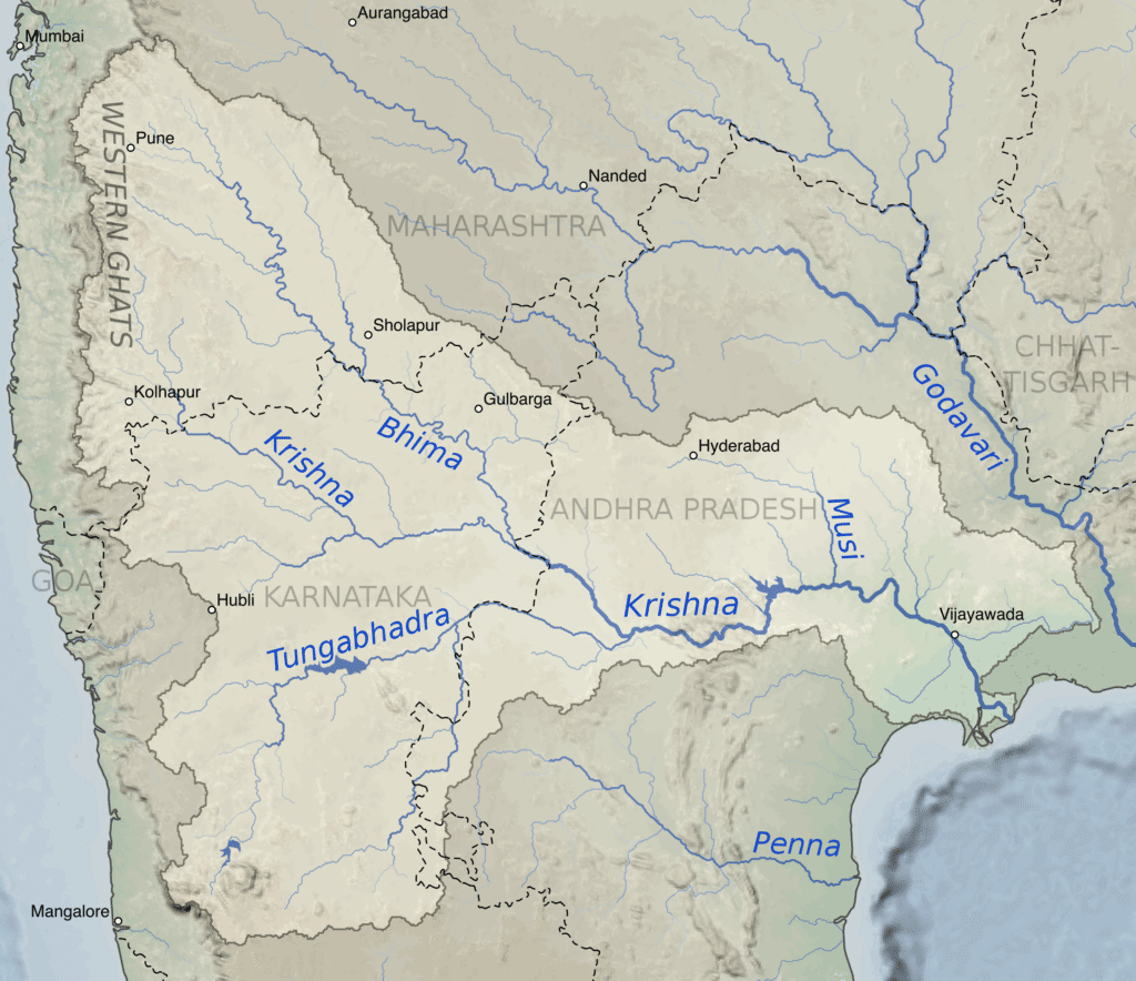
- Krishna River directly feeds Kolleru Lake.
- Meandering of Gandak River formed Kanwar Lake.
How many of the statements given above are correct?
(a) Only one
(b) Only two
(c) All three
(d) None
Answer: (a) Only one
Jhelum River
- The Jhelum River flows from the Indian union territory of Jammu and Kashmir into Pakistani Punjab, passing through the Pakistani-administered territory of Azad Kashmir.
- It is the westernmost of the Punjab region’s five rivers, and it flows through the Kashmir Valley.
- It is a Chenab River tributary with a total length of about 725 kilometres.
- The Jhelum originates at Vernag, in western Jammu and Kashmir union territory, in the Indian-administered portion of the Kashmir region, from a deep spring.
- The river flows northwestward from the Pir Panjal Range’s northern slope through the Vale of Kashmir to Srinagar’s Wular Lake, which regulates its flow. The Jhelum emerges from the lake and flows westward, cutting through the Pir Panjal in a gorge that is 7,000 feet (2,100 metres) deep and has almost perpendicular sides.
- The Jhelum River receives the Kishanganga River at Muzaffarabad, the administrative centre of Azad Kashmir in the Pakistani-administered sector of Kashmir, and then bends southward, forming part of the border between Azad Kashmir to the east and Khyber Pakhtunkhwa province, Pakistan, to the west.
- The river then flows into Punjab province to the south. The Jhelum River breaks through the Outer Himalayas near Mangla, forming broad alluvial plains. The river turns southwestward at Jhelum, following the Salt Range to Khushab, where it bends south again to join the Chenab River near Trimmu.
- The Jhelum is about 450 miles long in total (725 km). Up to the Line of Control (LOC), where it enters Pakistan, the total catchment area is about 15,856 km2.
- DAMS
- With a storage capacity of 5,900,000 acre-feet, the Mangla Dam, completed in 1967, is huge earth-fill dams.
- The Rasul Barrage, built in 1967, has a maximum flow of 850,000 feet per second.
- The Trimmu Barrage, built in 1939 near Jhang Sadar at the Chenab’s confluence, has a maximum discharge capacity of 645,000 ft3/s.
- Victoria Bridge (Haranpur) was built in 1933. Near Chak Nizam Village, about 5 kilometres from Malakwal. It has a length of one kilometre and is primarily used by Pakistan Railways.
- The Uri Dam, which has a 480 MW hydroelectric station, is located in Jammu and Kashmir’s Baramulla district.
- The Uri Dam II, which has a 240 MW hydroelectric station, is also in Jammu and Kashmir’s Baramulla district.
- Kishanganga Hydroelectric Plant is a 330 MW hydroelectric station in Jammu and Kashmir’s Bandipora district.

Krishna River
- The Krishna River is a river in the Deccan plateau and is the third-longest river in India, after the Ganges and Godavari.
- It is also the fourth-largest in terms of water inflows and river basin area in India, after the Ganges, Indus and Godavari.
- The river, also called Krishnaveni, it is 1,400 kilometres (870 mi) long and its length in Maharashtra is 282 kilometres.
- It is a major source of irrigation in the Indian states of Maharashtra, Karnataka, Telangana and Andhra Pradesh.
- The Krishna River originates in the Western Ghats near Mahabaleshwar at an elevation of about 1,300 metres (4,300 ft), in the state of Maharashtra in central India. From Mahabaleshwar it flows to the town of Wai and continues to travel east until it empties into the Bay of Bengal.
- The Krishna River has 13 major tributaries. Its principal tributaries include the Ghataprabha River, Malaprabha River, Bhima River, Tungabhadra River and Musi River.
- The Bhima River is the longest tributary of the Krishna River.
- Three tributaries Panchganga, Warna and Yerla meet Krishna river near Sangli. These places are considered very holy.
- It is said that Lord Dattatreya spent some of his days at Audumber on the banks of river Krishna.
- Waterfalls
- Ethipothala on Chandravanka river which is the tributary of river Krishna river.
- Godchinamalaki on Markandeya river a tributary of Ghataprabha.
- Gokak on Ghataprabha in Belagavi district of Karnataka.
- Mallela Theertham on Krishna River in the Nallamala Forest in Nagarkurnool, Telangana.
- Dams
- Nagarjunasagar Dam
- Srisailam Dam
- Almatti Dam
- Tungabhadra Dam
- Dhom Dam
- The Kolleru lake serves as a natural flood-balancing reservoir for two rivers. The lake is fed directly by water from the seasonal Budameru and Tammileru streams. It is connected to the Krishna (but not directly feeds) and Godavari systems by over 68 inflowing drains and channels.
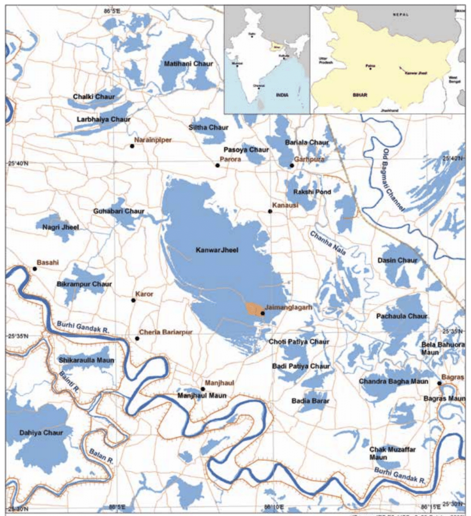
Kanwar Lake
- The Kanwar Taal or Kabar Taal Lake or Kabartal Wetland located in Begusarai district of Bihar, India, is Asia’s largest freshwater oxbow lake.
- It is the first Ramsar site in Bihar.
- It is a residual oxbow lake, formed due to meandering of Burhi Gandak river, a tributary of Ganga, in the geological past.
- Once a haven for migratory birds, the Kanwar lake in Bihar, Asia’s largest freshwater oxbow lake, is today a dying wetland ecosystem.
- Kanwar Lake was declared a notified area under the Wildlife (Protection) Act of 1972.
Q. Consider the following statements:
- Amarkantak Hills are at the confluence of Vindhya and Sahyadri Ranges.
- Biligirirangan Hills constitute the easternmost part of Satpura Range.
- Seshachalam Hills constitute the southernmost part of Western Ghats.
How many of the statements given above are correct?
(a) Only one
(b) Only two
(c) All three
(d) None
Answer: (d) None
Amarkantak Hills
- Amarkantak (NLK Amarakaṇṭaka) is a pilgrim town in Anuppur, Madhya Pradesh, India.
- The Amarkantak region is a unique natural heritage area and is the meeting point of the Vindhya and the Satpura Ranges, with the Maikal Hills being the fulcrum.
Biligirirangan Hills
- The Billigirirangan hills, also known as Biligiriranga Hills or BR Hills, are not a part of the Satpura range. The Biligirirangana Hills or Biligirirangan Hills is a hill range situated in south-western Karnataka, at its border with Tamil Nadu (Erode District) in South India.
- The area is called Biligiri Ranganatha Swamy Temple Wildlife Sanctuary or simply BRT Wildlife Sanctuary.
Sesachalam Hills
- The Sesachalam hills, also known as Tirumala hills, are not a part of the Western Ghats.
- Seshachalam Hills are hilly ranges part of the Eastern Ghats in southern Andhra Pradesh state, in southeastern India.
- The Seshachalam hill ranges are predominantly present in Tirupati district of the Rayalaseema region in Andhra Pradesh.
Q. Consider the following pairs :
Port : Well known as
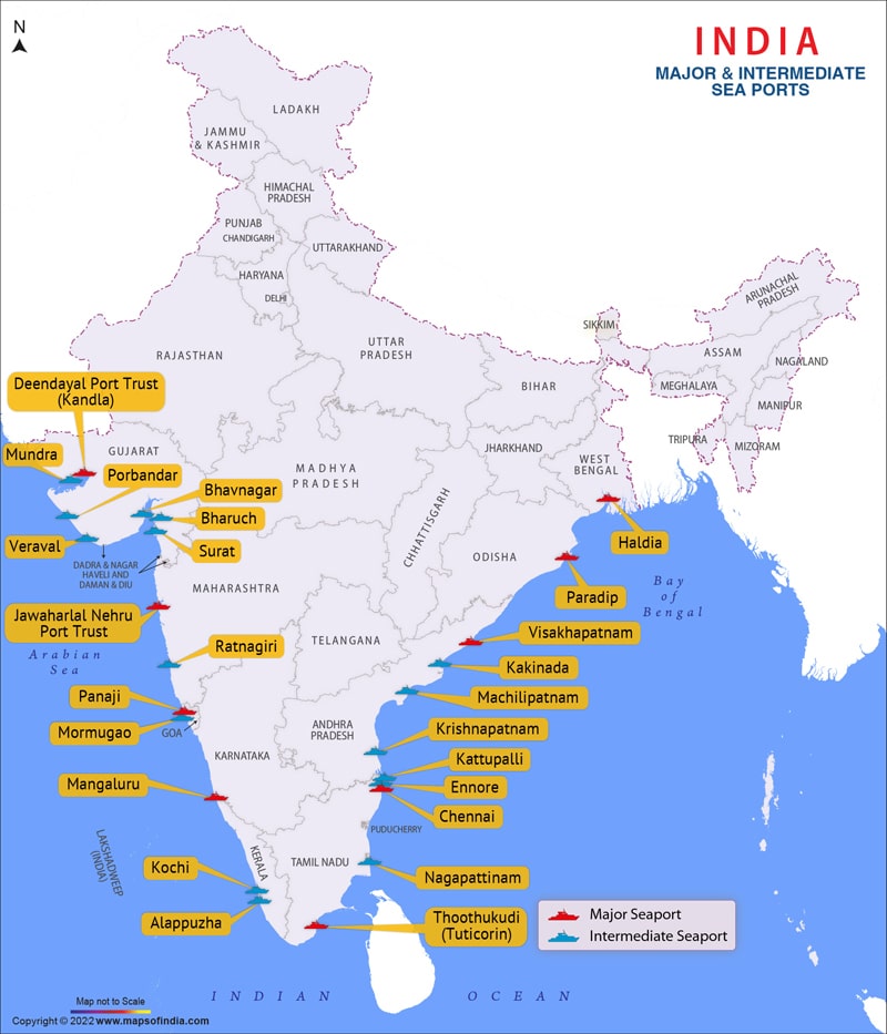
Kamaraj Port : First major port in India registered as a company
Mundra Port : Largest privately owned port in India
Visakhapatnam : Largest container port in Port India
How many of the above pairs are correctly matched?
(a) Only one pair
(b) Only two pairs
(c) All three pairs
(d) None of the pairs
Answer: (b) Only two pairs
Kamarajar Port
- Kamarajar Port, located on the Coromandel Coast about 24 km north of Chennai Port, Chennai, it is the 12th major port of India, and the first port in India which is a public company.
- The Kamarajar Port is the only corporatized major port and is registered as a company.
- Today, the landlord port is the dominant port model in larger and medium sized ports.
Mundra Port
- Mundra port is the largest private port in India.
- The port of Mundra is located on the north shores of the Gulf of Kutch near Mundra, Kutch district, in the state of Gujarat.
- Mundra is a major hub for containers and bulk cargo. It is run by Adani Ports and SEZ Limited (APSEZ) and began operations in 2001.
- Mundra Airport is undergoing major developments to convert it into an international airport for air cargo.
Visakhapatnam Port
- Visakhapatnam Port is one of 13 major ports in India and the only major port of Andhra Pradesh.
- It is India’s third largest state-owned port by volume of cargo handled and largest on the Eastern Coast.
- It is located midway between the Chennai and Kolkata Ports on the Bay of Bengal.
JNPT
- Jawaharlal Nehru Port Trust – Nhava Sheva (JNPT) is the largest container port in India and one of the most essential subcontinents harbours on the Western coast.
Q. Consider the following trees :
- Jackfruit (Artocarpus heterophyllus)
- Mahua (Madhuca indica)
- Teak (Tectona grandis)
How many of the above are deciduous trees?
(a) Only one
(b) Only two
(c) All three
(d) None
Answer: (b) Only two
Deciduous trees
- The term deciduous means “falling off at maturity” and “tending to fall off”, in reference to trees and shrubs that seasonally shed leaves, usually in the autumn; to the shedding of petals, after flowering; and to the shedding of ripe fruit.
- Deciduous trees are giant flowering plants. They include oaks, maples, and beeches, and they grow in many parts of the world.
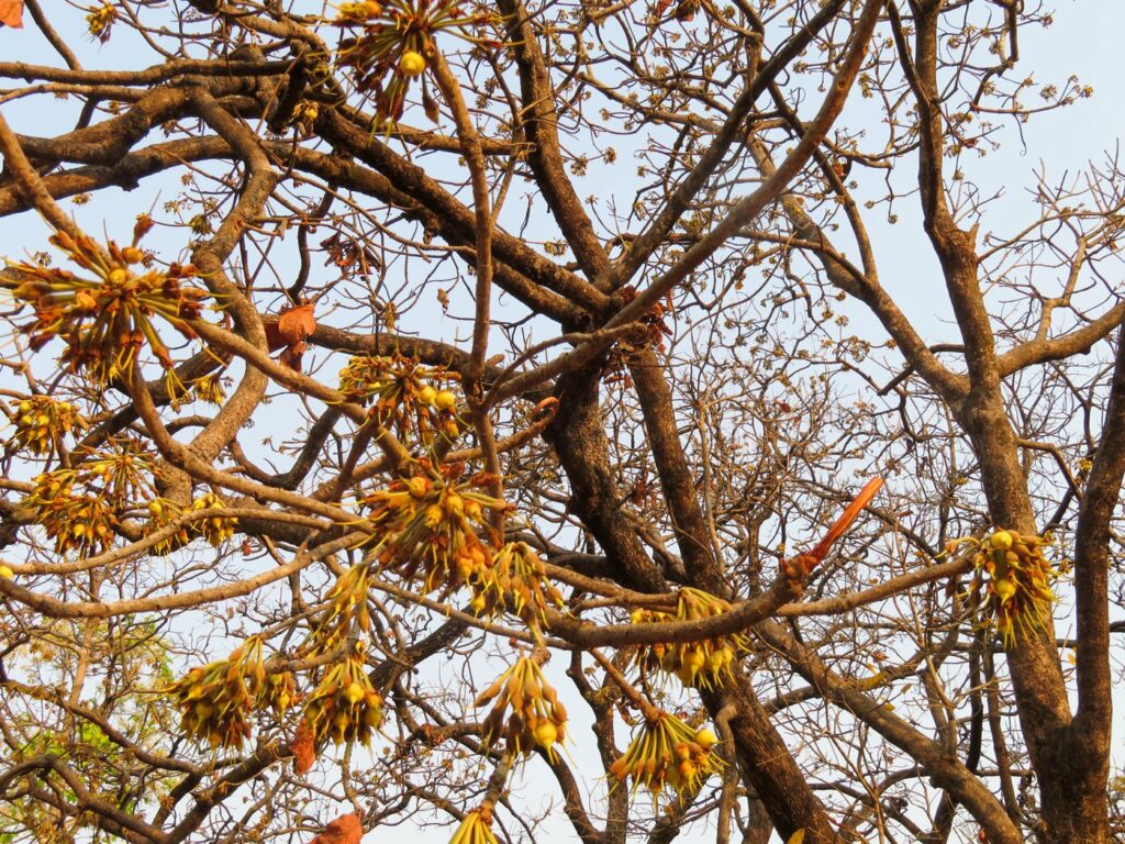
- The Moist deciduous forests are more pronounced in the regions which record rainfall between 100-200 cm. These forests are found in the northeastern states along the foothills of Himalayas, eastern slopes of the Western Ghats and Odisha. Teak, Sal, Shisham, Hurra, Mahua, Amla, Semul, Kusum, and Sandalwood etc. are the main species of these forests.

Tropical Evergreen trees
- These forests are restricted to heavy rainfall areas of the Western Ghats and the island groups of Lakshadweep, Andaman and Nicobar,upper parts of Assam and Tamil Nadu coast.
- They flourish in the areas having more than 200 cm of rainfall.
- The trees reach great heights up to 60 metres or even above.
- They occupy about 7% of the earth’s surface.
- They are found mostly near the equator.
- They have sparse undergrowth interspersed with clearings
- They have a scarce presence of litter (organic matter settling on the ground)
- These forests are dense and multi-layered.
- They harbor many types of plants and animals.
- The forests constitute an important part of the environment and ecology.
- These trees are an important component of the Forest Biology and ecosystem, that helps to promote life in the ecosystem. This allows the plants and animal life to harmonize and live with one another in absolute peace.
- Plants and Trees
- Ebony
- Mahogany
- Rosewood
- Rubber Chinchona
- Malabar Kino
- Bamboos
- Indian Laurel
- Jackfruit, (Artocarpus heterophyllus) is a tropical evergreen tree (family Moraceae) native to tropical Asia and widely grown throughout the wetland tropics for its large fruits and durable wood. The greenish unripe fruit is cooked as a vegetable, and the brown ripened fruit is eaten fresh for the sweetly acid but insipid pulp surrounding the seeds.

Q. Which one of the following is the best example of repeated falls in sea level, giving rise to present-day extensive marshland?
(a) Bhitarkanika Mangroves
(b) Marakkanam Salt Pans
(c) Naupada Swamp
(d) Rann of Kutch
Answer: (d) Rann of Kutch
Rann of Kutch
- The Rann of Kutch is the best example of repeated falls in sea level, giving rise to present-day extensive marshland.
- It is a vast seasonal salt marsh that experiences significant fluctuations in sea level due to its geological history.
- The Rann of Kutch was once an arm of the Arabian Sea, and as the sea level fell over time, it transformed into a marshy land. The region is known for its unique ecosystem, supporting a diverse range of flora and fauna, including migratory birds and endangered species.
- The Rann of Kutch is also famous for the annual Rann Utsav, a cultural festival that celebrates the vibrant traditions of the region.
Naupada swamp
- Naupada swamp, also known as Naupada Wetland, is located in Odisha, India.
- It is a freshwater swamp and is not primarily influenced by repeated falls in sea level. Instead, it is formed by the inflow of freshwater from rivers and receives seasonal rainwater.
Marakkanam Salt Pans
- Marakkanam salt pans, situated in Tamil Nadu, India, are salt marshes used for salt production.
- They are formed in low-lying coastal areas where seawater is allowed to evaporate, leaving behind salt crystals. However, these salt pans do not result from repeated falls in sea level but are created artificially by utilizing the existing seawater.
Bhitarkanika Mangroves
- Bhitarkanika mangroves, located in Odisha, India, is a significant mangrove ecosystem. While it experiences tidal fluctuations, it is not primarily characterized by repeated falls in sea level. Rather, it is influenced by the riverine system and is considered an important breeding ground for various species, including the endangered saltwater crocodile.
Q. Ilmenite and rutile, abundantly available in certain coastal tracts of India, are rich sources of which one of the following?
(a) Aluminium
(b) Copper
(c) Iron
(d) Titanium
Answer: (d) Titanium
Notes:
- Ilmenite (FeTiO3) and rutile (TiO2) are both minerals that contain high concentrations of titanium.
- Titanium is a strong and lightweight metal known for its excellent corrosion resistance and high strength-to-weight ratio. It is widely used in various industries, including aerospace, automotive, medical, and construction.
- In India, certain coastal tracts are known for their significant ilmenite and rutile deposits. These minerals are commonly found in beach sand deposits and are extracted through beach sand mining operations.
- The extracted ilmenite and rutile are processed to obtain titanium dioxide (TiO2), which is then further refined to produce metallic titanium. Therefore, ilmenite and rutile, found abundantly in certain coastal tracts of India, are valuable sources of titanium.
Q. About three-fourths of world’s cobalt, a metal required for the manufacture of batteries for electric motor vehicles, is produced by
(a) Argentina
(b) Botswana
(c) the Democratic Republic of the Congo
(d) Kazakhstan
Answer: (c) the Democratic Republic of the Congo
Notes:
- The Democratic Republic of the Congo (DRC) is the world’s largest producer of cobalt, accounting for about three-fourths (75%) of the global production. The country has been the top producer of the metal for some time, and reported output of 130,000 MT in 2022.
- Cobalt is a crucial component in the manufacture of batteries for electric vehicles, as well as for various electronic devices such as smartphones and laptops.
- There are several reasons why the DRC has become the primary source of cobalt production:
- Abundance of Cobalt Reserves:The DRC is home to vast reserves of cobalt. It is estimated to have approximately 3.4 million metric tons of cobalt reserves, which is the largest in the world. This abundance of cobalt resources has made the DRC a significant player in the global cobalt market.
- Artisanal Mining:A significant portion of cobalt production in the DRC comes from artisanal and small-scale mining operations. These operations involve individual miners or small groups extracting cobalt using basic tools and equipment. However, due to the informal nature of this mining sector, it can be associated with challenges such as poor working conditions, environmental concerns, and potential human rights issues.
- Industrial Mining Operations:Alongside artisanal mining, the DRC also has large-scale industrial mining operations run by multinational mining companies. These operations use modern machinery and technologies to extract cobalt from mines. The industrial mining sector plays a crucial role in meeting the global demand for cobalt.

Q. Which one of the following is a part of the Congo Basin?
(a) Cameroon
(b) Nigeria
(c) South Sudan
(d) Uganda
Answer: (a) Cameroon
Congo Basin
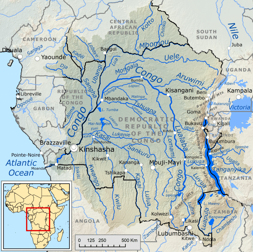
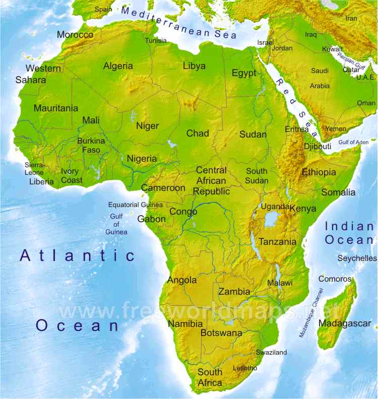
- The Congo Basin is the sedimentary basin of the Congo River. The Congo Basin is located in Central Africa, in a region known as west equatorial Africa.
- The Congo Basin region is sometimes known simply as the Congo. It contains some of the largest tropical rainforests in the world and is an important source of water used in agriculture and energy generation.
- The rainforest in the Congo Basin is the largest rainforest in Africa and second only to the Amazon rainforest in size.
- Countries wholly or partially in the Congo region:
- Angola
- Gabon
- Burundi
- Cameroon
- Central African Republic
- Democratic Republic of the Congo
- Republic of the Congo
- Rwanda
- Tanzania
- Zambia
Q. Consider the following statements :
Statement-I : India, despite having uranium deposits, depends on coal for most of its electricity production.
Statement-II : Uranium, enriched to the extent of at least 60%, is required for the production of electricity.
Which one of the following is correct in respect of the above statements?
(a) Both Statement-I and Statement-II are correct and Statement-II is the correct explanation for Statement-I
(b) Both Statement-I and Statement-II are correct and Statement-II is not the correct explanation for Statement-I
(c) Statement-I is correct but Statement-II is incorrect
(d) Statement-I is incorrect but Statement-II is correct
Answer: (c) Statement-I is correct but Statement-II is incorrect
Notes:
- Both conventional (thermal, nuclear, and hydro) and renewable (wind, solar, biomass, etc.) energy sources are used to produce electricity in India. However, the majority of electricity is produced by coal-fired thermal power plants, which provide about 58% of the total electricity. In the year 2021–2022, approximately 3.15 per cent of the nation’s electricity was generated using nuclear energy.
- Uranium enrichment of U235 isotope 3 to 5 percent is required for electricity generation. Research reactors use uranium that has been highly enriched to a concentration of at least 20%.
- At least 90% enriched Uranium is considered as weapons grade uranium.
Also Read: Uranium and Thorium Distribution
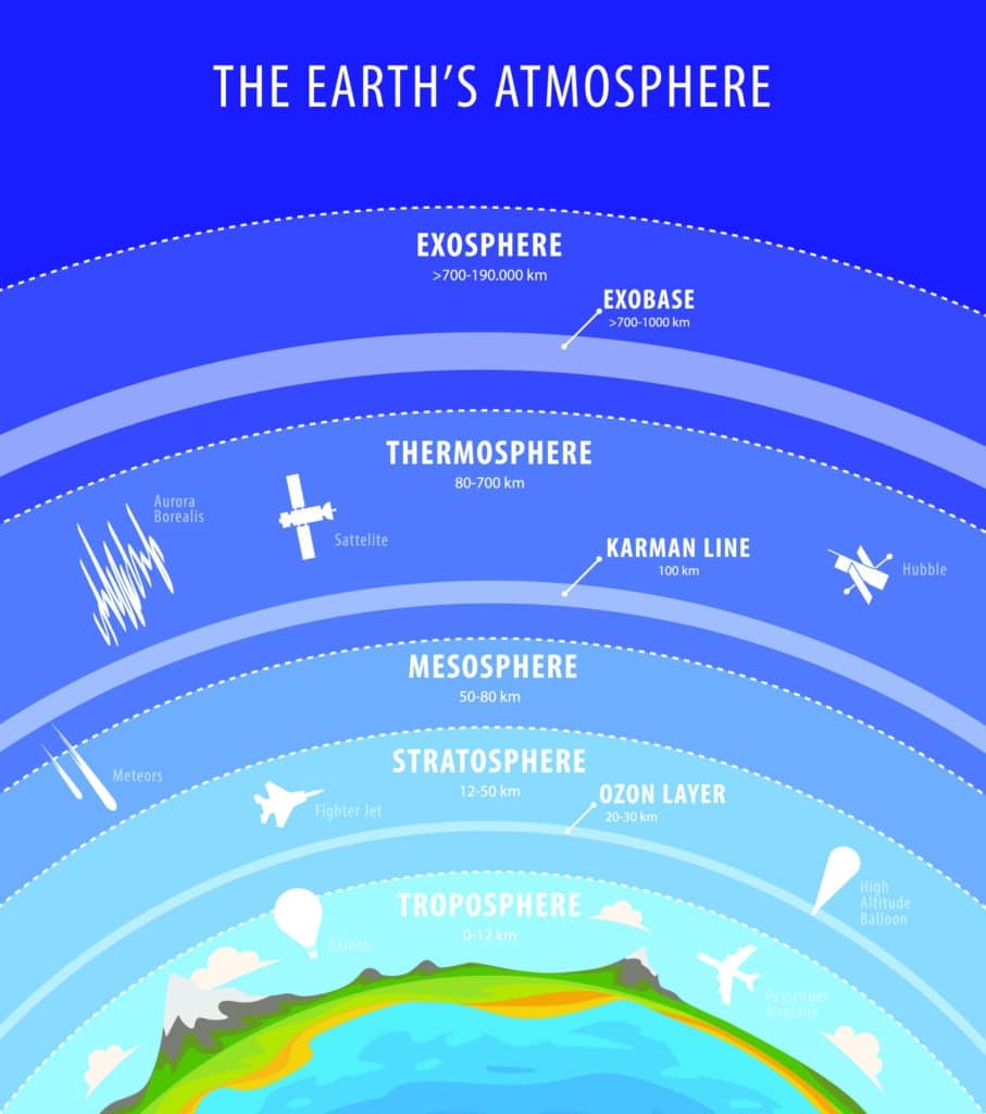
Q. With reference to the Earth’s atmosphere, which one of the following statements is correct?
(a) The total amount of insolation received at the equator is roughly about 10 times of that received at the poles.
(b) Infrared rays constitute roughly two-thirds of insolation.
(c) Infrared waves are largely absorbed by water vapour that is concentrated in the lower atmosphere.
(d) Infrared waves are a part of visible spectrum of electromagnetic waves of solar radiation.
Answer: (c) Infrared waves are largely absorbed by water vapour that is concentrated in the lower atmosphere.
Notes:
- While it is true that the equator receives more direct sunlight compared to the poles, the actual difference in insolation is not as large as ten times. The difference in insolation between the equator and poles is primarily due to the curvature of the Earth and the tilt of its axis, resulting in varying angles at which sunlight reaches different latitudes.
- Insolation refers to the total solar radiation received at the Earth’s surface, which includes a broad spectrum of electromagnetic radiation. While infrared radiation is a significant component of solar radiation, it does not account for two-thirds of the insolation. Insolation includes visible light, ultraviolet (UV) radiation, and other wavelengths as well.
- Water vapor is a potent absorber of infrared radiation, particularly in certain wavelength bands. In the lower atmosphere, where water vapor concentration is relatively higher, it absorbs a significant amount of infrared radiation emitted by the Earth’s surface. This absorption contributes to the greenhouse effect and plays a crucial role in regulating the Earth’s temperature.
- Infrared waves and visible light waves are distinct parts of the electromagnetic spectrum. The visible spectrum ranges from approximately 400 to 700 nanometers and includes the colors we perceive, such as red, orange, yellow, green, blue, and violet. Infrared radiation, on the other hand, has longer wavelengths than visible light and is not visible to the human eye. It lies just beyond the red end of the visible spectrum and is typically divided into near-infrared, mid-infrared, and far-infrared regions based on wavelength.
Q. Consider the following statements
Statement-I : The soil in tropical rain forests is rich in nutrients.
Statement-II : The high temperature and moisture of tropical rain forests cause dead organic matter in the soil to decompose quickly.
Which one of the following is correct in respect of the above statements?
(a) Both Statement-I and Statement-II are correct and Statement-II is the correct explanation for Statement-I
(b) Both Statement-I and Statement-II are correct and Statement-II is not the correct explanation for Statement-I
(c) Statement-I is correct but Statement-II is incorrect
(d) Statement-I is incorrect but Statement-II is correct
Answer: (d) Statement-I is incorrect but Statement-II is correct
Notes:
- Tropical rain forest soil is very poor in nutrient which are required by plants to grow. This is due to acidic nature of soil and incessant rains.
- Potassium, calcium, magnesium and phospohorous are lost away due to leaching. Thus, regeneration is very slow.
- Tropical rainforests typically experience warm and consistent temperatures throughout the year. These elevated temperatures enhance the activity of soil microorganisms responsible for decomposing organic matter. Increased microbial activity leads to faster decomposition rates. Rainforests receive abundant rainfall, creating high levels of soil moisture. Moisture is crucial for microbial activity and the breakdown of organic matter. It facilitates the enzymatic processes involved in decomposition, providing a suitable environment for decomposers like bacteria and fungi.
Q. Consider the following statements :
Statement-I : The temperature contrast between continents and oceans is greater during summer than in winter.
Statement-II : The specific heat of water is more than that of land surface.
Which one of the following is correct in respect of ihe above statements?
(a) Both Statement-I and Statement-II are correct and Statement-II is the correct explanation for Statement-I
(b) Both Statement-I and Statement-II are correct and Statement-II is not the correct explanation for Statement-I
(c) Statement-I is correct but Statement-II is incorrect
(d) Statement-I is incorrect but Statement-II is correct
Answer: (a) Both Statement-I and Statement-II are correct and Statement-II is the correct explanation for Statement-I
Notes:
- The temperature contrast between continents and oceans is greater during the summer than in the winter. During summer, land heats up more quickly than the ocean, causing a large temperature difference. Conversely, in the winter, land cools down more quickly than the ocean, but the effect is typically less pronounced than the contrast seen in summer due to the overall lower temperatures.
- The specific heat of water is more than that of land surface. Specific heat is the amount of heat per unit mass required to raise the temperature by one degree Celsius. Water has a higher specific heat than land, meaning it requires more energy to raise its temperature, so it heats up and cools down more slowly than land.
Q. Consider the following statements :
- In a seismograph, P waves are recorded earlier than S waves.
- In P waves, the individual particles vibrate to and fro in the direction of wave propagation whereas in S waves, the particles vibrate up and down at right angles to the direction of wave propagation.
Which of the statements given above is/are correct?
(a) 1 only
(b) 2 only
(c) Both 1 and 2
(d) Neither 1 nor 2
Answer: (c) Both 1 and 2
Notes:
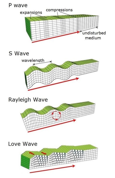
- P waves, or Primary waves, are the first waves to arrive at a seismograph. P waves are the fastest seismic waves and can move through solid, liquid, or gas. They leave behind a trail of compressions and rarefactions on the medium they move through. P waves are also called pressure waves for this reason.
- P waves are longitudinal waves, which means that the particle motion occurs parallel to the direction of wave propagation. These waves are compression waves, where particles oscillate back and forth in the same direction that the wave is traveling. As a result, the individual particles vibrate to and in the direction of wave propagation.
- On the other hand, S waves are transverse waves, where particle motion occurs perpendicular (at right angles) to the direction of wave propagation. These waves cause the particles to move up and down or side to side perpendicular to the direction of the wave. Therefore, in S waves, the particles vibrate up and down at right angles to the direction of wave propagation.
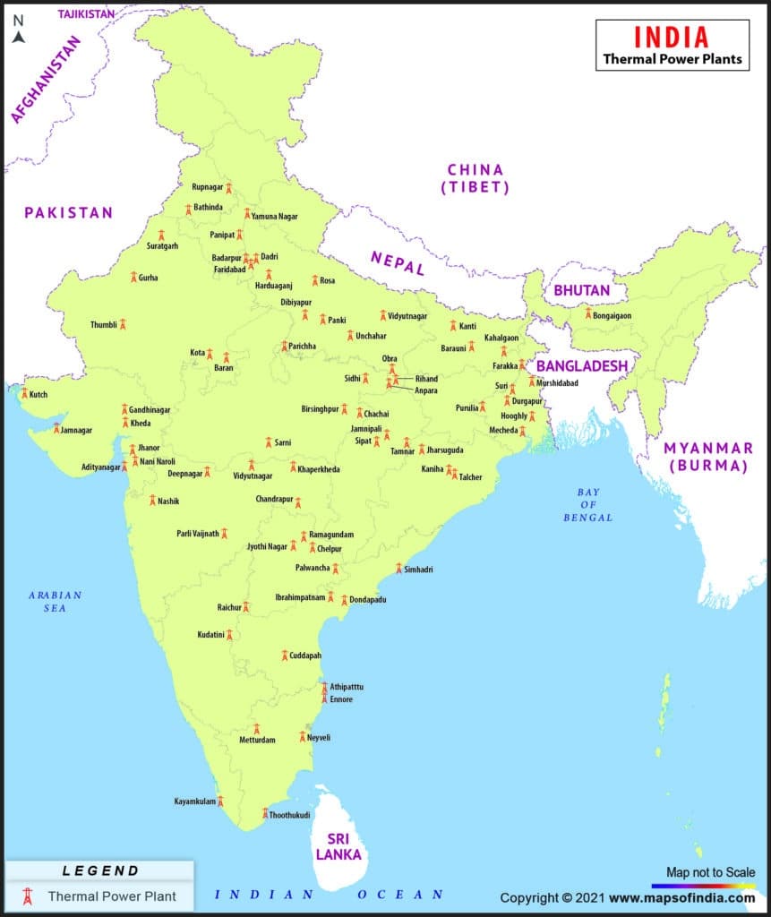
Q. With reference to coal-based thermal power plants in India, consider the following statements :
- None of them uses seawater.
- None of them is set up in water-stressed district.
- None of them is privately owned.
How many of the above statements are correct?
(a) Only one
(b) Only two
(c) All three
(d) None
Answer: (d) None
Notes:
- The Mundra Thermal Power Plant employs a closed-cycle induced draft circulating cooling water system that utilizes seawater. Seawater is drawn from the Gulf of Kutch through robust glass reinforced pipes of significant diameter. In addition, purified seawater from a reverse osmosis plant is utilized by various supplementary systems.
- According to recent research by WRI (World Resources Institute), 40 percent of India’s thermal power plants are situated in regions experiencing significant water stress. This poses a challenge as these plants rely on water for cooling purposes. The scarcity of water is already causing disruptions in electricity generation in these areas, with 14 out of India’s 20 largest thermal utilities having experienced at least one shutdown between 2013 and 2016 due to water shortages. These shutdowns have resulted in significant financial losses, amounting to $1.4 billion for the affected companies.
- India has a total of 269 Thermal Power Plants, with 138 of them being owned by the public sector and the remaining 131 owned by the private sector.
Q. Which one of the following countries has been suffering from decades of civil strife and food shortages and was in news in the recent past for its very severe famine?
(a) Angola
(b) Costa Rica
(c) Ecuador
(d) Somalia
Answer: (d) Somalia
Notes:
- Somalia is the country that has been suffering from decades of civil strife and food shortages.
- It was in the news in the recent past for its very severe famine.
- The famine in Somalia is a result of a catastrophic combination of conflict, high food prices, and drought.
- This has left more than 11 million people in desperate need.
- The country is currently experiencing its worst drought in nearly 40 years.
- A looming famine could leave more than 8 million people without enough food to eat by next summer.
- Somalia has seen three decades of conflict, destabilizing communities.
- Currently, it produces less than half the amount of food it did before its civil war began in the early 1990s.
- This has forced the country to become increasingly dependent on aid.
