Q. The terms ‘Event Horizon’, ‘Singularity’, ‘String Theory’ and ‘Standard Model’ are sometimes seen in the news in the context of
(a) Observation and understanding of the Universe
(b) Study of the solar and the lunar eclipses
(c) Placing satellites in the orbit of the Earth
(d) Origin and evolution of living organisms on the Earth
Answer: (a) Observation and understanding of the Universe
Notes:
- The standard model of particle physics is a mathematical model that describes electromagnetism, the strong and weak nuclear forces, and the Higgs mechanism.
- String theory is used in the context of quantum physics that is used to understand quantum phenomena.
- The basic structure of a black hole consists of a singularity hidden by an event horizon.
- Within the event horizon, the escape velocity exceeds the velocity of the light and an object is trapped forever.

String Theory
- String Theory is a theoretical framework in which the point-like particles of particle physics are replaced by one-dimensional objects called strings.
- String theory describes how these strings propagate through space and interact with each other.
- On distance scales larger than the string scale, a string looks just like an ordinary particle, with its mass, charge, and other properties determined by the vibrational state of the string.
- In string theory, one of the many vibrational states of the string corresponds to the graviton, a quantum mechanical particle that carries the gravitational force. Thus, string theory is a theory of quantum gravity.
Q. Which of the following practices can help in water conservation in agriculture?
- Reduced or zero tillage of the land
- Applying gypsum before irrigating the field
- Allowing crop residue to remain in the field
Select the correct answer using the code given
(a) 1 and 2 only
(b) 3 only
(c) 1 and 3 only
(d) 1, 2 and 3
Answer: (c) 1 and 3 only
Notes:
- Using surface residue covers to increase infiltration and reduce runoff.
- A residue cover absorbs most of the energy of the raindrops that fall on it and by the time this rainwater reaches the soil below, its ability to disintegrate soil aggregates and detach fine particles is greatly reduced.
- Using Impermeable and permeable contour barriers at discrete intervals downslope combined with reduced tillage, or preferably zero tillage as in conservation agriculture.
- The incorporation of lime without or with gypsum will reduce toxic concentrations of aluminium and/or manganese to non-toxic levels and so encourage deeper rooting enabling the crop to access more soil moisture. Gypsum increase the porosity of soil, in result which increase water infiltration in soil.
Q. Which of the following is geographically closest to Great Nicobar?
(a) Sumatra
(b) Borneo
(c) Java
(d) Sri Lanka
Answer: (a) Sumatra
Great Nicobar
- Great Nicobar lies on the south of the Nicobar Islands of India. It is the largest island of the Nicobar Islands.
- The Sumatra island lies to the south of Great Nicobar.
- Sumatra is closest to Great Nicobar. The distance between the two places is 1,192 kms.
- The distance from Great Nicobar to Borneo is 2,398 kms.
- The distance from Great Nicobar to Java stands at 1,817 kms.
- The distance from Great Nicobar to Sri Lanka is 1437 kms.
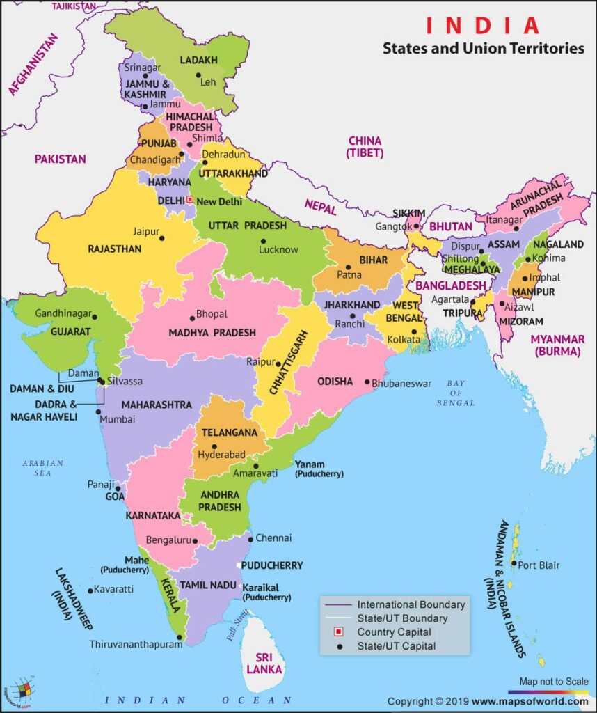
Q. If you travel by road from Kohima to Kottayam, what is the minimum number of States within India through which you can travel, including the origin and the destination?
(a) 6
(b) 7
(c) 8
(d) 9
Answer: (b) 7
Notes:
- If you travel by road from Kohima to Kottayam, You need to cross Kohima is the capital of Nagaland (origin), Assam, West Bengal, Odisha, Andhra Pradesh and then through either Tamil Nadu to Kerala (Kottayam-destination), or through AP to Karnataka to Kerala (Kottayam-destination).
- So the minimum number of States within India through which you can travel, including the origin and the destination is seven.
Q. Consider the following statements:
- In India, the Himalayas are spread over five States only.
- Western Ghats are spread over five States only.
- Pulicat Lake is spread over two States only.
Which of the statements given above is/are correct?
(a) 1 and 2 only
(b) 3 only
(c) 2 and 3 only
(d) 1 and 3 only
Answer: (b) 3 only
Notes:
- The Indian Himalayan Region is spread across these Indian States/UTs: Jammu & Kashmir, Ladakh, Uttarakhand, Himachal Pradesh, Arunachal Pradesh, Manipur, Meghalaya, Mizoram, Nagaland, Sikkim, Tripura, two districts of Assam namely Dima Hasao and Karbi Anglong and Darjeeling and Kalimpong in West Bengal).
- Western Ghats are spread over six states: Kerala, Tamil Nadu, Karnataka, Goa, Maharashtra and Gujarat.
- Pulicat Lake is the second largest brackish water lake in India and spreads over the two states namely the Andhra Pradesh and Tamil Nadu.
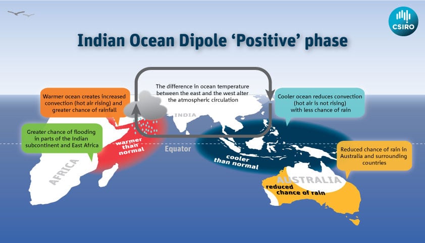
Q. With reference to ‘Indian Ocean Dipole (IOD)’ sometimes mentioned in the news while forecasting Indian monsoon, which of the following statements is/are correct?
- IOD phenomenon is characterised by a difference in sea surface temperature between tropical Western Indian Ocean and tropical Eastern Pacific Ocean.
- An IOD phenomenon can influence an EI Nino’s impact on the monsoon.
Select the correct answer using the code given below:
(a) 1 only
(b) 2 only
(c) Both 1 and 2
(d) Neither 1 nor 2
Answer: (b) 2 only
Indian Ocean Dipole (IOD)
- It is the difference in sea surface temperature between two poles or areas (hence a dipole) i.e. an eastern pole in the eastern Indian Ocean south of Indonesia, and a western pole in the Arabian Sea (western Indian Ocean).
- The IOD affects the climate of countries that surround the Indian Ocean Basin like India, Australia and others, and is a significant contributor to rainfall variability in this region.
- The IOD, in scientific terms, is a coupled ocean and atmosphere phenomenon, similar to El Nino–Southern Oscillation (ENSO) but in the equatorial Indian Ocean.
- Through an extension of the Walker Circulation to the west and associated Indonesian throughflow (the flow of warm tropical ocean water from the Pacific into the Indian Ocean), it is thought that the IOD has a link with ENSO events.
- Hence, negative IOD events are often associated with La Nina and positive events with El Nino.
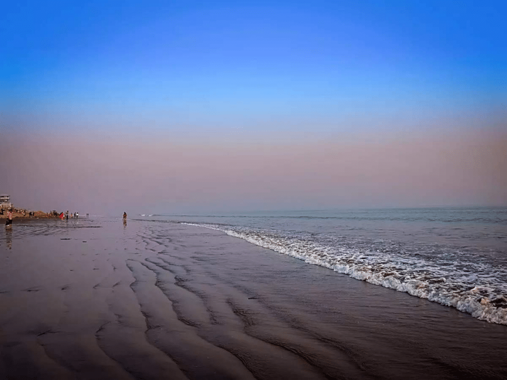
Q. At one of the places in India, if you stand on the seashore and watch the sea, you will find that the seawater recedes from the shoreline a few kilometers and comes back to the shore, twice a day, and you can actually walk on the sea floor when the water recedes. This unique phenomenon is seen at
(a) Bhavnagar
(b) Bheemunipatnam
(c) Chandipur
(d) Nagapattinam
Answer: (c) Chandipur
Notes:
- At one of the places in India, if you stand on the seashore and watch the sea, you will find that the seawater recedes from the shoreline a few kilometres and comes back to the shore, twice a day, and you can actually walk on the seafloor when the water recedes. This unique phenomenon is seen at Chandipur.
- Chandipur Beach is in Odisha
- Chandipur Beach is also called the ‘hide-and-seek’ beach.
- Chandipur also has the DRDO (Defence Research and Development Organization) Integrated Research Range.
- In this range ballistic missiles are test-fired.
- Chandipur Beach is also a great place for fresh seafood.
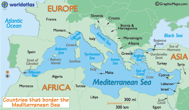
Q. The Mediterranean Sea is a border of which of the following countries?
- Jordan
- Iraq
- Lebanon
- Syria
Select the correct answer using the code given below:
(a) 1, 2 and 3 only
(b) 2 and 3 only
(c) 3 and 4 only
(d) 1, 3 and 4 only
Answer: (c) 3 and 4 only
Notes:
- The Mediterranean Sea is bordered by 21 countries. They are Albania, Algeria, Bosnia and Herzegovina, Croatia, Cyprus, Egypt, France, Greece, Israel, Italy, Lebanon, Libya, Malta, Monaco, Montenegro, Morocco, Slovenia, Spain, Syria, Tunisia, and Turkey.
- The Mediterranean Sea is connected to the Atlantic Ocean by a narrow passage called the Strait of Gibraltar.
Q. With reference to river Teesta, consider the following statements
- The source of river Teesta is the same as that of Brahamputra but it flows through Sikkim
- River Rangeet originates in Sikkim and it is a tributary of river Teesta.
- River Teesta flows into Bay of Bengal on the border of India and Bangladesh.
Which of the statements given above is/are correct?
(a) 1 and 3 only
(b) 2 only
(c) 1 and 3 only
(d) 1, 2 and 3
Answer: (b) 2 only
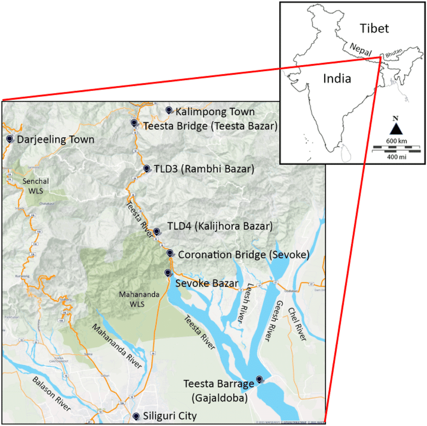
Teesta River
- Teesta River originates from the Pahunri glacier (not from the same source as the Brahmaputra).
- The Brahmaputra originates in the Angsi glacier near Mount Kailash.
- Teesta is one of the right tributaries of Brahmaputra.
- Before going to the Bay of Bengal through Bangladesh Teesta flows through West Bengal and Sikkim.
- River Rangeet originates in Sikkim which is the largest river in Sikkim and also a tributary of river Teesta.
Tributaries
- Left
- Rangpo River
- Lachung River
- Ranikhola
- Relli River
- Talung River
- Dik Chhu
- Lang Lang Chu
- Right
- Rangeet River
- Kanaka River
- Ringyong Chhu
- Ranghap Chhu
Jaldhaka River
- The Jaldhaka River, also known as Dichu, a tributary of Brahmaputra is a trans-boundary river flowing through India, Bhutan and Bangladesh with a length of 233 kilometres.
- It originates from the Bitang Lake at Kupup, Gangtok District, Sikkim, near the Jelep La pass below Dongkya Mountain Range.
- It passes through Neora Valley National Park, Chapramari Wildlife Sanctuary & Gorumara National Park in West Bengal.
