

- Navigable waters in India total about 14,500 km, and they long accounted for only about 1% of the country’s transport. They include canals, backwaters, rivers, creeks and many other water bodies.
- The share has since reached about 2%, with a target of 5%. Compared with other countries, these waterways remain underused.
- Around 3,700 km of major rivers can take mechanised flat-bottomed vessels, of which only about 2,000 km has actually been used.
- Only about 900 km of the navigable canals, given as 4,800 km and also as about 4,300 km, can take mechanised vessels.
- These waterways then carried about 180 lakh tonnes of cargo, or 18.1 million tonnes in 2013-14.
- National Waterways Act, 2016: in effect from 12 April 2016, it added 106 new national waterways to the 5 declared earlier, and replaced the 5 separate Acts behind them.
- IWAI picked out the new waterways and reported them to the then Ministry of Shipping (MoS).
- IWAI is responsible for carrying out national waterway projects on time and improving water transport.
- The Act thus declares 111 inland waterways as national waterways, across 20,187 km in 23 States and 4 Union Territories.
- Of the 111, 13 were at first listed as operational, with cargo and passenger vessels moving on them. The count rose from 24 to 29 during 2024-25.
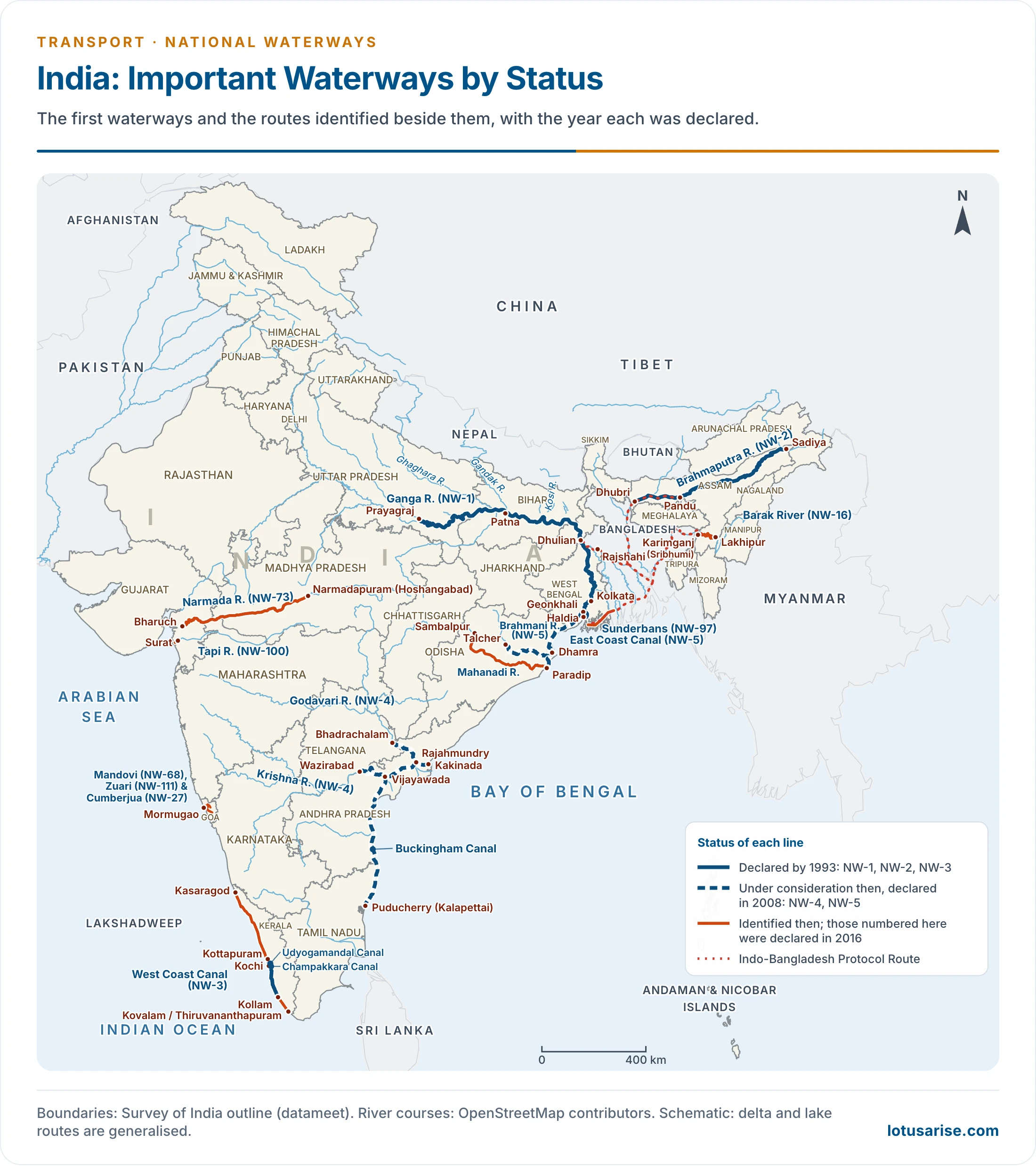
- This map shows the first waterways and the routes identified beside them. The Barak and Narmada lines were declared in 2016.
Inland Water Transport Today
Cargo and Passenger Traffic
| Year | Cargo on national waterways (million tonnes) |
|---|---|
| 2013-14 | 18.1 |
| 2014-15 | 29 |
| 2024-25 | 145.5 |
| 2025-26 | 218 |
- The 2025-26 figure passes the 200 million tonne target set for 2030 under the Maritime India Vision. The longer aim is over 500 million tonnes by 2047.
- Operational length grew from 2,716 km (2014-15) to 4,894 km (2023-24).
- Coal, iron ore, iron ore fines, sand and fly ash made up over 68% of cargo in 2024-25. Passengers reached 1.61 crore in 2023-24.
- Country boats add a large unorganised traffic in passengers and goods on rivers, lakes and canals, for which no complete record exists.
Inland Waterways Authority of India
- This body was created by the Government of India on 27 October 1986, under an Act of 1985, to regulate and develop inland waterways for shipping and navigation.
- It chiefly undertakes development and maintenance of inland water transport (IWT) infrastructure on national waterways.
- It carries out these projects through grants from the Shipping Ministry, now the Ministry of Ports, Shipping and Waterways.
- Its headquarters is in Noida.
- It also has regional offices at Patna, Kolkata, Guwahati, Varanasi, Bhubaneswar and Kochi, with sub-offices in other towns.
Policy and Projects
- Jal Marg Vikas Project: capacity building on the Haldia–Varanasi stretch of NW-1 with World Bank support, at an estimated ₹5,369.18 crore, for vessels of 1,500–2,000 tonnes.
- Multi-modal terminals at Varanasi (opened 12 November 2018), Sahibganj (2019) and Haldia, with an inter-modal terminal at Kalughat, are moving to the Syama Prasad Mookerjee Port for operation.
- Jalvahak scheme (15 December 2024): with ₹95.42 crore, it repays cargo owners 35% of operating costs for shifting freight from road or rail, and runs scheduled services on NW-1, NW-2 and NW-16.
- Law and tax: the Inland Vessels Act, 2021, the extension of tonnage tax to inland vessels (2025), and the jetties and terminals regulations of 2025 that open the sector to private investment.
- River tourism: MV Ganga Vilas, flagged off on 13 January 2023, sailed about 3,200 km in 51 days from Varanasi to Dibrugarh through India and Bangladesh.
- Brahmaputra: foundation stones for India’s first riverine lighthouses were laid on 5 March 2026 at Pandu, Bogibeel, Silghat and Biswanath Ghat.
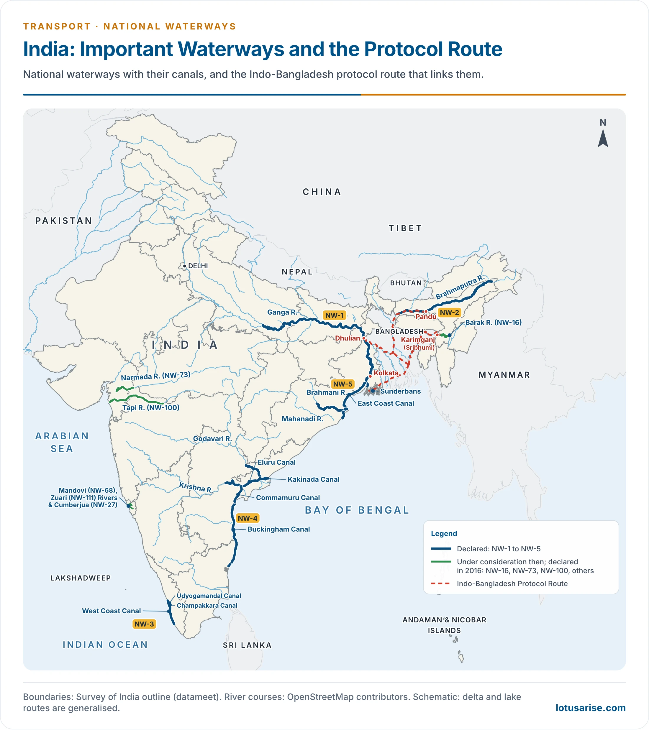
- Cross-border routes: the Protocol on Inland Water Transit and Trade with Bangladesh, first signed in 1972, links NW-1, NW-2 and NW-16. A 2020 addendum raised its routes from eight to ten.
National Waterways
- National Waterway 1 (NW-1):
- It runs from Prayagraj (Allahabad) to Haldia, a distance of 1,620 km, and was declared on 27 October 1986 under an Act of 1982.
- NW-1 runs through the Ganga, Bhagirathi and Hooghly river system, with fixed terminals at Haldia, Farakka and Patna and floating terminals at most riverside cities, such as Kolkata, Bhagalpur, Varanasi and Prayagraj.
- It was long counted the longest national waterway in India.
- For development it falls into three parts: Patna–Prayagraj (600 km), Farakka–Patna (460 km) and Haldia–Farakka (560 km).
- National Waterway 2 (NW-2):
- It is a stretch of the Brahmaputra from Sadiya to Dhubri in Assam, declared on 26 October 1988.
- NW-2 is a major freight waterway of north-east India and, at 891 km, the third-longest among the first five.
- National Waterway 3 (NW-3), the West Coast Canal:
- It lies in Keralam (Kerala) and runs from Kollam to Kottapuram, declared in 1993.
- The 205 km West Coast Canal route was India’s first waterway with round-the-clock navigation.
- NW-3 consists of the West Coast Canal, Champakara Canal and Udyogmandal Canal, of 168, 23 and 14 km, and runs through Kottapuram, Cherthala, Thrikkunnapuzha, Kollam and Alappuzha.
- The 2016 schedule adds a further 170 km from Kottapuram to Kozhikode.
- National Waterway 4 (NW-4):
- It connects Kakinada to Puducherry (Pondicherry) through canals, the Kaluvelly Tank and the Godavari and Krishna rivers, and was declared in 2008.
- NW-4 was the second-longest waterway of the first five, with a total length of 1,095 km in Andhra Pradesh, Tamil Nadu and Puducherry.
- The 2016 schedule keeps the canal system (1,078 km) and adds the Godavari from Bhadrachalam to Nashik (1,202 km) and the Krishna from Wazirabad to Galagali (636 km). The commonly quoted length is about 2,890 km, though these parts add to 2,916 km. It is the longest on the list, and it runs into Telangana, Chhattisgarh, Karnataka and Maharashtra.
- National Waterway 5 (NW-5):
- It connects Odisha to West Bengal, using the Brahmani river, the East Coast Canal, the Matai river and the Mahanadi delta, and was declared in 2008.
- The 623 km canal system was planned to handle coal, fertiliser, cement and iron. The 2016 schedule gives 588 km: East Coast Canal and Matai 256 km, Brahmani–Kharsua–Dhamra 265 km, and Mahanadi delta 67 km.
- The Barak waterway (planned as NW-6, now NW-16):
- It was proposed in Assam, to connect Lakhipur to Bhanga on the river Barak.
- The 121 km waterway helps trade between the town of Silchar and Mizoram.
- The 2016 Act declared it National Waterway 16. The number NW-6 now belongs to the Aai river in Assam, 68 km long.
Operational National Waterways in India
- The table sets out the first list of operational waterways, with their routes and States.
| NW Number | River System | Route | Locations |
|---|---|---|---|
| NW-1 | Ganga-Bhagirathi-Hooghly | Prayagraj–Haldia | Uttar Pradesh, Bihar, Jharkhand, West Bengal |
| NW-2 | Brahmaputra | Sadiya–Dhubri | Assam |
| NW-3 | West Coast Canal, Champakara Canal and Udyogmandal Canal | Kottapuram–Kollam | Keralam |
| NW-4 | Krishna and Godavari | Kakinada–Puducherry stretch of canals, Kaluvelly Tank, Bhadrachalam–Rajahmundry, Wazirabad–Vijayawada | Andhra Pradesh, Tamil Nadu and Puducherry |
| NW-10 | Amba River | – | Maharashtra |
| NW-83 | Rajpuri Creek | – | Maharashtra |
| NW-85 | Revadanda Creek–Kundalika River System | – | Maharashtra |
| NW-91 | Shastri river–Jaigad creek system | – | Maharashtra |
| NW-68 | Mandovi | Usgaon Bridge to the Arabian Sea | Goa |
| NW-111 | Zuari | Sanvordem Bridge to Mormugao Port | Goa |
| NW-73 | Narmada River | – | Gujarat and Maharashtra |
| NW-100 | Tapi River | – | Gujarat and Maharashtra |
| NW-97 (Sundarbans Waterways) | Namkhana to Athara Banki Khal | Indo-Bangladesh Protocol Route | West Bengal |
25 National Waterways Found Feasible for Cargo or Passenger Movement
- A wider review then found 25 waterways feasible. Reports completed by early 2019 put the number at 30.
| National Waterway | Details of Waterways | States |
|---|---|---|
| National Waterway 1 | Ganga-Bhagirathi-Hooghly River System (Haldia–Allahabad) | Uttar Pradesh, Bihar, Jharkhand and West Bengal |
| National Waterway 2 | Brahmaputra River (Dhubri–Sadiya) | Assam |
| National Waterway 16 | Barak River | Assam |
| National Waterway 3 | West Coast Canal (Kottapuram–Kollam), Champakara and Udyogmandal Canals | Keralam |
| National Waterway 4 | Krishna River (Vijayawada–Muktyala) | Andhra Pradesh |
| National Waterway 5 | Dhamra–Paradip via Mangalagadi to Pankopal | Odisha |
| National Waterway 8 | Alappuzha–Changanassery Canal | Keralam |
| National Waterway 9 | Alappuzha–Kottayam–Athirampuzha Canal | Keralam; alternate route of 11.5 km |
| National Waterway 27 | Cumberjua River | Goa |
| National Waterway 68 | Mandovi River | Goa |
| National Waterway 86 | Rupnarayan River | West Bengal |
| National Waterway 97 | Sundarbans Waterway | West Bengal |
| National Waterway 111 | Zuari River | Goa |
| National Waterway 10 | Amba River | Maharashtra |
| National Waterway 40 | Ghaghara River | Bihar and Uttar Pradesh |
| National Waterway 44 | Ichamati River | West Bengal |
| National Waterway 52 | Kali River | Karnataka |
| National Waterway 57 | Kopili River | Assam |
| National Waterway 25 | Chapora River | Goa |
| National Waterway 37 | Gandak River | Bihar and Uttar Pradesh |
| National Waterway 28 | Dabhol Creek and Vashishti River | Maharashtra |
| National Waterway 73 | Narmada River | Maharashtra and Gujarat |
| National Waterway 85 | Revadanda Creek–Kundalika River System | Maharashtra |
| National Waterway 94 | Sone River | Bihar |
| National Waterway 100 | Tapi River | Maharashtra and Gujarat |
River Transport and Regional Development
Development of River Transport
- Pre-colonial period: rivers were the chief highways of north India. The Ganga and the Brahmaputra carried trade and tied together towns along their banks, and river traffic supported the growth of trade across the plains.
- Colonial period: the railways, laid from the later 19th century to serve the port cities, drew traffic away. Water transport could not match their speed.
- After Independence:
- Diversion for irrigation and silting reduced depth, and roads took short-haul traffic, leaving water with about 1% of transport.
- Revival began with the Allahabad–Haldia Act of 1982, the creation of IWAI in 1986, and the first declarations from 1986 to 2008.
- The 2016 Act and the Jal Marg Vikas Project then scaled it up.
| Period | Role of river transport | Main constraint |
|---|---|---|
| Pre-colonial | Main freight route across the northern plains | Seasonal flow, slow speed |
| Colonial | Pushed aside by railways built towards ports | Competition from rail |
| 1947–1986 | Marginal, confined to a few stretches | Irrigation diversion, silting, road growth |
| Since 1986 | Slow revival, then rapid cargo growth after 2016 | Depth, terminals, last-mile links |
Role in Regional Development
- Cost: cheap carriage of coal, iron ore, sand and fly ash lowers input costs for power plants and industry along the rivers. This matters most for bulky, low-value goods.
- The north-east: NW-2 and NW-16, with the Bangladesh protocol routes, give Assam, Tripura and Barak valley an alternative to the narrow land corridor through north Bengal.
- Deltas and backwaters: in the Ganga–Brahmaputra delta and Keralam’s backwaters, boats reach places that roads serve poorly.
- The middle Ganga: terminals at Varanasi and Sahibganj connect eastern Uttar Pradesh, Bihar and Jharkhand to Kolkata and Haldia.
- Livelihoods: boat-building, fishing, ferries and river cruises add local work.
- Limits: gains stay close to the terminals unless road and rail links reach them.
National Waterway 1: Problems and Prospects
- Problems:
- Low and varying depth: the Ganga loses much of its flow in the dry months. Maintained depth targets of about 3 m apply only on some stretches.
- Ganga silt, shifting shoals and bends demand repeated dredging, which is costly.
- Diversion of water upstream for irrigation, and the barrage at Farakka that the route must pass.
- Shortage of barges, reported at about 100 short in 2019, which limits regular services.
- Terminal and last-mile gaps: cargo must transfer between road, rail and river, which can raise total cost.
- Prospects:
- It runs through Uttar Pradesh, Bihar, Jharkhand and West Bengal, a dense market for bulk freight such as coal and fly ash.
- The Varanasi, Sahibganj and Haldia terminals tie the river to road and rail.
- Haldia and Kolkata give it an outlet to the sea, and the protocol routes link it to Bangladesh and the North-East.
- Jalvahak services on the Kolkata–Patna–Varanasi route and river cruises add regular traffic.
Previous Year Questions
2016Bring out the development of river water transport in India and its role in regional development.2014Discuss the problems and prospects of National Waterway No. 1.2004Give a comparative account of the development of River Water Transport in pre-colonial and post-independence periods in India. Highlight the role of River Transport in regional development.





Helpful 👍