

Soil Profile and Soil Horizons

Soil is conventionally described as the thin, weathered mantle of the Earth’s crust composed of mineral particles, organic matter, water, and air, capable of supporting plant life. But for Geography Optional purposes, the more analytically useful definition treats soil as a three-dimensional natural body — one that has length and breadth (extending across the landscape) and, critically, depth, along which its properties change systematically. This vertical dimension is what the soil profile captures.
A soil profile is the vertical section of soil, exposed by a cut (natural, such as a river bank, or artificial, such as a soil pit), running from the ground surface down to the unaltered parent material. It reveals a sequence of more or less distinct layers called soil horizons, each differing from the ones above and below it in colour, texture, structure, consistency, chemical composition, and biological activity.
The Soil Profile: Structure and Terminology
The Three Broad Layers
Traditionally, a mature soil profile is described as having three broad horizontal layers:
- Solum (true soil) — subdivided into topsoil and subsoil
- Substratum — the underlying, less altered material
- Bedrock — the unweathered parent rock at the base

Each layer differs in feel (texture), colour, depth, and chemical composition. These differences arise because horizons are formed through in-situ processes such as leaching (downward removal of soluble and suspended material by percolating water) and capillary movement (upward movement of water and dissolved salts by evaporation-driven suction) — the same processes responsible for horizon-specific enrichment or depletion of nutrients.
A soil profile is conventionally studied through a hexagonal (or monolith) column of soil extracted intact from the field, allowing all horizons to be observed together, in sequence, without disturbance — this monolith method is standard in soil survey and museum pedology alike.
Regolith, Solum, and Saprolite
While the O-A-B-C-R scheme is descriptive, geographers must also understand the genetic architecture of the weathering profile, since this is what actually links soil formation to geomorphology:
- Regolith is the entire mantle of loose, unconsolidated weathered material overlying solid bedrock — it includes everything from the surface humus down to the point where fresh rock begins.
- The regolith itself has two components:
- Solum: the upper part of the regolith in which active soil-forming (pedogenic) processes operate — broadly corresponding to the A and B horizons. This is “soil” in the strict pedological sense.
- Saprolite: the least-weathered portion of the regolith, lying directly above solid, consolidated bedrock. It retains the structure of the parent rock but is chemically altered and friable — corresponding to the lower C horizon.
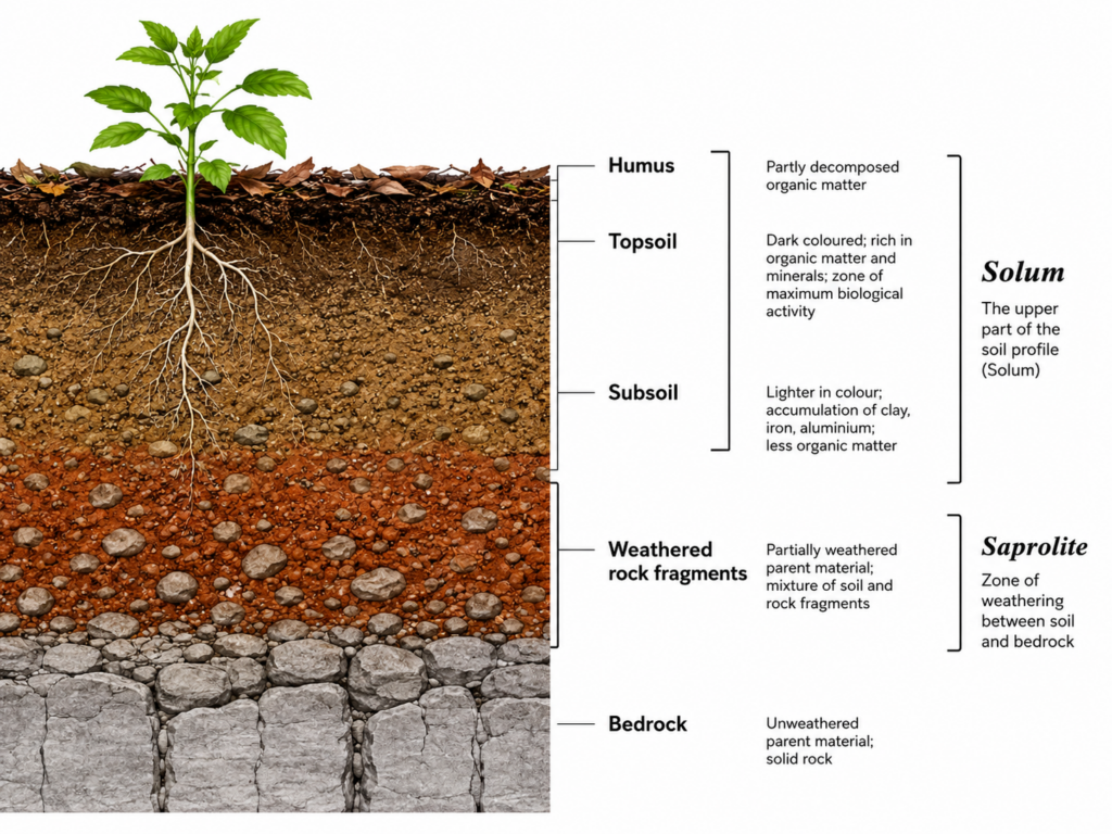
This regolith framework is important because it links the soil profile to the broader concept of the weathering profile used in geomorphology (relevant, for instance, to laterite formation and duricrust studies), and it clarifies why the C horizon is sometimes equated with saprolite in sedimentary or residual soils but not in soils formed on transported material (alluvium, loess, glacial till), where there is no in-situ parent rock beneath.
Why Horizons Form: The Genetic Framework
Horizons are not arbitrary descriptive layers — they are the product of pedogenesis, and Geography Optional answers score higher when horizon description is tied back to process. Two classical frameworks anchor this discussion:
Dokuchaev and the Concept of Soil as an Independent Natural Body
V.V. Dokuchaev (1883), the father of modern pedology, first proposed that soil is not merely disintegrated rock but an independent natural body formed by the combined action of climate, organisms, parent material, and time acting upon relief over a period. This was revolutionary because it shifted soil science from a purely geological (rock-derived) view to an ecological–genetic view, and it laid the foundation for the zonal, intrazonal, and azonal classification of world soils based on the degree of horizon development a soil has been able to achieve.
Jenny’s CLORPT Equation
Hans Jenny (1941) formalised Dokuchaev’s insight mathematically:
S = f (Cl, O, R, P, T)
where soil (S) is a function of Climate, Organisms, Relief, Parent material, and Time. Horizon differentiation is essentially the visible signature of this equation:
- Climate governs the intensity of leaching, the rate of chemical weathering, and biological activity, thereby controlling horizon thickness and the degree of translocation (e.g., deep, well-differentiated horizons in humid tropics versus thin, weakly developed profiles in arid climates).
- Organisms (vegetation, soil fauna, microorganisms) determine humus accumulation in the O and A horizons and drive nutrient cycling.
- Relief controls drainage and erosion rates, and hence whether horizons can accumulate undisturbed (as explained further under the catena concept, Section 6).
- Parent material supplies the initial mineralogy that weathering and translocation act upon.
- Time is the factor of profile maturity — a young soil (entisol) may show almost no horizon differentiation, while an old, stable surface allows a fully differentiated profile (with distinct E, Bt, or Bk horizons) to develop.
Translocation Processes
Within this framework, four specific translocation processes are chiefly responsible for how horizons acquire their distinguishing chemical signatures — each is examined in detail in the companion article on Natural Processes of Soil Enrichment, but must be recalled here as the mechanism behind the eluvial (E, upper) and illuvial (B, lower) horizon relationship:
- Podzolization — intense leaching of iron, aluminium, and organic colloids from an eluvial horizon in cool, humid, coniferous-forest climates, leaving a bleached, ash-grey E horizon and an iron/organic-enriched Bs horizon below.
- Laterization — intense chemical weathering under hot, humid tropical conditions, causing silica to be leached out while sesquioxides of iron and aluminium (which are relatively insoluble) accumulate residually, producing a reddish, oxide-rich B horizon and, at the extreme, laterite duricrusts.
- Calcification — accumulation of calcium carbonate in the B horizon (forming a Bk or “kankar” horizon) under semi-arid to sub-humid conditions where evapotranspiration exceeds precipitation for much of the year, limiting leaching depth.
- Salinization — upward capillary movement and surface accumulation of soluble salts in arid and poorly drained conditions, producing saline (solonchak-type) surface horizons.
Types of Soil Horizons: Organic vs Mineral
Soil horizons develop through the interaction among climate, living organisms, and the land surface over time. They form through the selective removal or accumulation of ions, colloids, and chemical compounds, a process driven by water percolating through the profile from the surface toward deeper layers. Because of this, horizons at different depths often display markedly different textures and colours.
There are two fundamental categories of horizons:
- Organic horizons, designated with the capital letter O, lying above mineral horizons and formed from plant and animal remains.
- Mineral horizons, of which there are four main types: A, E, B, and C (with R representing bedrock, sometimes treated as a fifth reference layer).
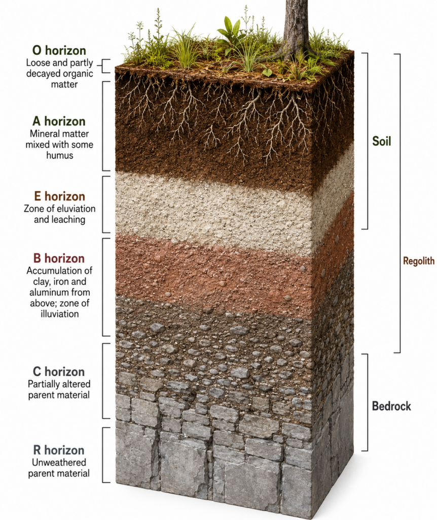
1. Organic (O) Horizon
- Composed of layers dominated by organic material rather than mineral matter.
- Subdivided (in detailed soil taxonomy) into:
- Oi — slightly decomposed litter, where original plant structures (leaves, twigs, needles) are still recognisable.
- Oe — moderately decomposed material.
- Oa — highly decomposed humus (sometimes called mor, moder, or mull humus depending on decomposition rate and mixing with mineral soil).
- O horizons may consist of undecomposed or partially decomposed litter such as leaves, needles, twigs, moss, and lichens.
- They may overlie either mineral or organic soils (e.g., histosols/peat soils are almost entirely O-horizon material).
- Best developed under forest cover with slow decomposition (cool, moist, or acidic conditions); largely absent or very thin in grasslands and cultivated soils where litter is rapidly incorporated or removed.
2. A Horizon (Topsoil / Surface Soil)
- Forms the upper part of the true soil and is the layer most examined for agricultural purposes.
- Here, organic matter is mixed with mineral matter — it is the horizon of maximum organic matter accumulation and biological activity (roots, earthworms, microbes).
- Typically the darkest horizon, owing to humus content; this dark colour and granular structure make it the most fertile part of the profile.
- Nutrients such as iron, aluminium, clay, and organic matter are sometimes dissolved and translocated out of this layer — i.e., the A horizon is often depleted (eluviated) of clay, iron, aluminium, organic compounds, and other soluble constituents that move downward.
- Where this depletion is pronounced, a distinctly lighter-coloured E horizon becomes visible immediately beneath the A horizon.
- Sub-divided in detailed description into Ap (ploughed/disturbed surface layer in cultivated soils), A1, A2, etc.
3. E Horizon (Eluvial Horizon)
- The letter “E” stands for eluviated — from the Latin e- (out) + luere (to wash).
- A light-coloured, leached layer that has lost much of its fine material and nutrients to horizons below.
- It has been significantly leached of clay, iron, and aluminium oxides, leaving behind a residual concentration of resistant, coarse minerals — chiefly quartz — in the sand and silt fractions. This is why E horizons often appear pale, ashy, or bleached (the classic podzol “ash layer”).
- E horizons are present only in older, well-developed soils and generally occur sandwiched between the A and B horizons.
- Their presence or absence is itself diagnostic: a sharp, well-expressed E horizon is characteristic of podzols under coniferous forest, while it is typically absent in young soils, arid soils, and most Indian tropical soils where either laterization (residual accumulation, not clean eluviation) or insufficient leaching time prevents its formation.
4. B Horizon (Subsoil)
- A subsurface layer reflecting chemical or physical alteration of the parent material — it is the horizon of maximum illuviation (accumulation), the mirror-image process of eluviation.
- This layer accumulates leached minerals from the A and E horizons above — hence iron, clay, aluminium, and organic compounds accumulate here (illuviation being the opposite of eluviation).
- Sub-horizon suffixes used in soil taxonomy to describe what has accumulated are important for precise, exam-ready answers:
- Bt — accumulation of translocated silicate clay (argillic horizon)
- Bw — weak structural/colour alteration without significant illuviation (cambic horizon)
- Bs — accumulation of iron/aluminium sesquioxides and organic matter (spodic horizon, classic podzol B)
- Bk — accumulation of secondary calcium carbonate (calcic horizon — the “kankar” layer of Indian black and arid soils)
- By/Bz — accumulation of gypsum or soluble salts respectively
- The B horizon is typically denser, more compact, and higher in clay content than the A horizon, giving it lower permeability — a fact with direct agronomic consequences (e.g., perched water tables above a clay-rich Bt horizon).
5. C Horizon (Parent Material / Substratum)
- The layer where partially weathered parent material accumulates — in sedimentary or transported deposits, this is literally the parent material of the overlying solum.
- It is the least weathered horizon possessing pedogenic characteristics, and is also known as the saprolite, being unconsolidated, loose parent material.
- May accumulate more soluble compounds (inorganic material such as calcium carbonate or gypsum nodules) that have been leached all the way down from the horizons above but not yet lost from the profile entirely.
- In residual soils, the C horizon grades gradually into bedrock; in transported soils (alluvium, loess, colluvium), the C horizon may bear no genetic relationship to the underlying rock at all.
6. R Horizon (Bedrock)
- Denotes the layer of unweathered (or minimally weathered) bedrock at the base of the soil profile.
- Unlike the horizons above it, the R horizon largely comprises a continuous mass of hard, coherent rock rather than loose particles.
- Soils formed in situ (residual soils) exhibit strong mineralogical and structural similarity to this underlying bedrock layer — this is a key diagnostic used to distinguish residual soils (e.g., regur/black soil over Deccan basalt) from transported soils (e.g., alluvium, which shows no such relationship to the material beneath it).
- Zones of exposed or shallow (within roughly 50 feet, per common soil-survey convention) bedrock are mapped separately from deeper profiles, since they support very different land-use and engineering considerations.
Idealised Master Horizon Sequence
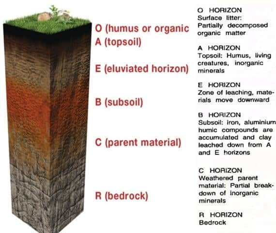
Combining the above, the complete idealised (maximally differentiated) soil profile, from surface to depth, reads:
| Horizon | Common name | Key characteristic |
|---|---|---|
| O | Organic / litter | Undecomposed to well-decomposed organic matter |
| A | Topsoil | Humus-mineral mixture; zone of eluviation |
| E | Eluviated horizon | Light-coloured; leached of clay, Fe, Al |
| B | Subsoil | Zone of illuviation; clay/Fe/Al/carbonate accumulation |
| C | Parent material / saprolite | Weathered but unconsolidated parent rock |
| R | Bedrock | Consolidated, largely unweathered rock |
It must be stressed for Optional-level rigour that no single soil profile displays all six horizons simultaneously — the number and thickness of horizons expressed is itself a function of Jenny’s CLORPT variables. A young alluvial soil on the Gangetic plain may show only a weak A-C profile, while a mature laterite in Kerala or an old podzol under Himalayan conifers may display a fully differentiated O-A-E-B-C-R sequence. The degree of horizonation is thus itself a proxy for soil age/maturity and is used directly in soil classification (e.g., distinguishing Entisols/Inceptisols from Alfisols/Ultisols/Spodosols in USDA Soil Taxonomy, or azonal from zonal soils in the older Russian scheme).
The Catena Concept: Horizons Across a Slope
A purely vertical reading of the soil profile is incomplete without situating it within the catena concept (Milne, 1935) — the idea that soils occurring at different points along a hillslope, though derived from the same parent material and under the same climate, differ systematically because of differences in drainage and relief position. On a typical toposequence:
- Summit/upper slope soils tend to be shallow, well-drained, and often show truncated or weakly developed A horizons due to active erosion.
- Mid-slope soils are typically the best-developed, most mature profiles, since material is neither excessively removed nor excessively received.
- Footslope/valley-bottom soils receive colluvial and alluvial deposition from upslope, are often poorly drained, and may show gleyed (bluish-grey, waterlogged) horizons and greater illuvial accumulation (thick Bt or hydromorphic features).
This lateral dimension is essential for a complete Geography Optional answer, since it links the vertical soil profile to slope processes, drainage, and land capability — themes that recur across geomorphology, soil geography, and agricultural geography questions alike.
Indian Soil Profiles: Applying the Framework
No Geography Optional answer on soil horizons is complete without grounding the theory in Indian soil types, since profile characteristics are precisely what distinguish India’s major soil orders:
- Alluvial soils (Indo-Gangetic plains, ~40% of India’s area): Young, transported soils with weak horizon differentiation — typically only a shallow A horizon over a thick, stratified C horizon reflecting successive depositional layers (khadar and bhangar sub-types differ by age and hence by degree of profile maturity).
- Black/Regur soils (Deccan Trap region): Derived in situ from basalt, these are self-ploughing (self-mulching) soils with deep cracking on drying; they typically show a poorly differentiated A-C profile (rather than a distinct B horizon) because intense shrink-swell activity of montmorillonite clay physically mixes the horizons — a case where mineralogy overrides normal horizon differentiation. A calcic Bk (kankar) horizon is often present at depth due to calcification under the semi-arid Deccan climate.
- Red and Yellow soils (Peninsular India, on granite-gneiss): Show moderate horizon development with a reddish B horizon due to iron oxide (hematite) enrichment under sub-humid conditions; the yellow colour appears where hydration of iron oxides to limonite occurs under poorer drainage.
- Laterite soils (Western Ghats, Eastern Ghats, parts of Odisha/Chhattisgarh, Kerala): The classic Indian example of laterization — intense leaching of silica under high rainfall and temperature leaves a residual, iron/aluminium-oxide-rich B horizon that, on exposure and alternating wet-dry cycles, hardens irreversibly into laterite duricrust — a process geographers term hardening on exposure, of direct relevance to both soil degradation and building-material geography (laterite blocks are a traditional Kerala construction material).
- Arid/Desert soils (Rajasthan, Kutch): Extremely thin, weakly developed A horizon over a sandy C horizon; frequent calcification (Bk/kankar pan) and localised salinization due to high evapotranspiration and poor leaching.
- Mountain/Podzolic soils (Himalayan conifer belt): The only region in India approaching classical podzolization, with an organic O horizon, a bleached E horizon, and an iron/organic-enriched Bs horizon under cool, humid, coniferous-forest conditions.
- Saline and Alkaline soils (parts of Punjab, Haryana, Gujarat — usar/reh soils): Show pronounced salt accumulation in surface horizons due to capillary rise in poorly drained, canal-irrigated tracts — a profile signature directly relevant to the secondary salinization debate in Indian irrigation policy.
Significance of the Soil Profile
- The study of the soil profile is of central importance in agricultural sciences, since land-use patterns can be determined directly from the depth, texture, and fertility characteristics of the horizons present.
- Land capability classification — the standard framework (developed by the USDA and adapted by India’s National Bureau of Soil Survey and Land Use Planning, NBSS&LUP) used to grade land into capability classes I–VIII for planning purposes — is based fundamentally on the study of the soil profile and its horizons, particularly depth to bedrock/hardpan, texture, drainage, and erosion status.
- Horizon-level data (depth of A horizon, presence of restrictive Bt/Bk layers, drainage class) feed directly into soil survey and mapping programmes, crop-suitability assessments, irrigation planning, and watershed management.
- The profile is also central to soil degradation diagnostics — for instance, sheet erosion is diagnosed by progressive thinning or loss of the A horizon, while the appearance of a hardened lateritic crust or exposed Bk pan at the surface indicates severe, often irreversible, degradation.
- In the context of climate change and soil carbon geography, the O and A horizons constitute the principal near-surface organic carbon pool; their disturbance through deforestation, tillage, or erosion is a major pathway of soil-carbon loss to the atmosphere, linking pedology directly to climate mitigation policy (e.g., India’s soil organic carbon mapping initiatives under the National Mission for Sustainable Agriculture).
- Modern remote sensing and GIS-based digital soil mapping increasingly infer horizon properties (organic content, moisture, texture) from spectral signatures, making the classical profile-based framework the ground-truth basis against which such remote techniques are calibrated.





thank you
Fabulous