UPSC History Optional Map Solution 2016

History Optional Mapping PYQs Solution: Map Based Questions with Solution – 2016 History Optional Mains Examination.
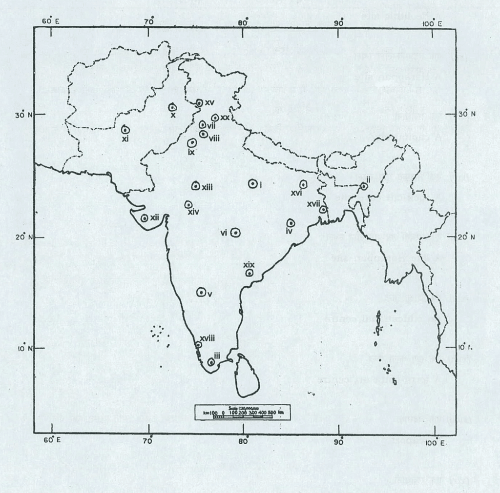
Q. Identify the following places marked on the map supplied to you and write a short note of about 30 words on each of them in your Question-cum-Answer Booklet. Locational hints for each of the places marked on the map are given below seriatim:
- (i) A mesolithic site
- (ii) A Neolithic site
- (iii) A Mesolithic-Chalcolithic site
- (iv) A Neolithic site
- (v) A Neolithic site
- (vi) A Megalithic site
- (vii) A site known for Buddhist remains
- (viii) A Harappan site
- (ix) A Harappan site
- (x) A Harappan site
- (xi) A Neolithic site
- (xii) A Harappan site
- (xiii) A Capital city
- (xiv) A Rock-cut cave site
- (xv) A Late Harappan site
- (xvi) An Educational center
- (xvii) A Terra-cotta are center
- (xviii) A Seaport
- (xix) A capital city
- (xx) A capital city
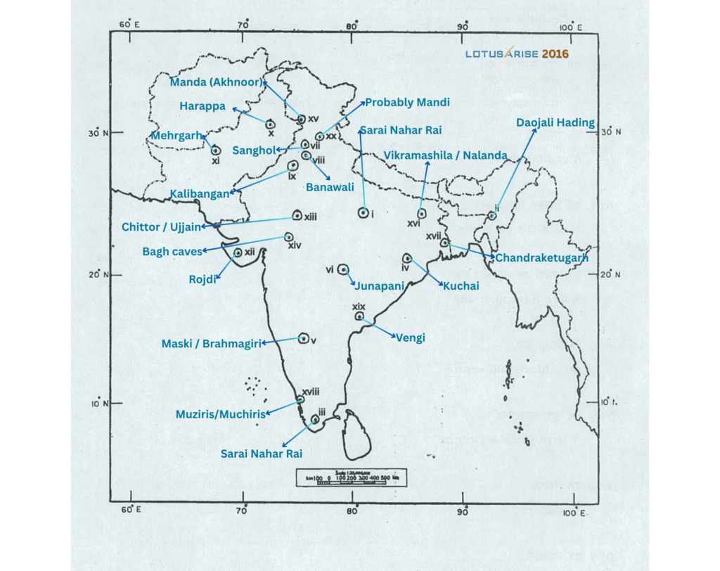
Mapping PYQs Solution 2016:
- A Mesolithic site: Sarai Nahar Rai / Mahadaha, Chopani Mando
- A Neolithic site: Daojali Hading
- A Megalithic-Chalcolithic site: Adichanallur
- A Neolithic site: Kuchai
- A Neolithic site: Maski / Brahmagiri
- A Megalithic site: Junapani
- A site known for Buddhist remains: Sanghol
- A Harappan site: Banawali
- A Harappan site: Kalibangan
- A Harappan site: Harappa (There is no major Harappan site here. The nearest major site is Harappa.)
- A Neolithic site: Mehrgarh
- A Harappan site: Rojdi
- A capital city: Chittor / Ujjain
- A rock-cut cave site: Bagh caves
- A Late Harappan site: Manda (Akhnoor)
- An educational centre: Vikramashila / Nalanda
- A terracotta art centre: Chandraketugarh
- A seaport: Muziris/Muchiris
- A capital city: Vengi / Amaravati/ Dhanyakataka
- A capital city: Probably Mandi
These 20 sites are Question 1 of Paper I in the 2016 History Optional examination — 2.5 marks each, 50 marks in total, with a note of about 30 words expected on every one. Each is solved in full below. The complete 2016 paper is at History Optional Question Paper 2016.
The map is 50 marks. What about the other 450?
You have the map answers on this page, free, for every site UPSC marked in 2016. That is 50 marks dealt with. The other 450 marks of the 2016 papers are still sitting there unanswered — and those are the marks that separate 260 from 320.
The History Optional PYQ Master Pack carries a written model answer for every question the Commission has set since 1985, including every non-map question on the 2016 paper.
- PYQs from 1985 to 2025 — arranged topic-wise, so you revise a theme and see every way it has been asked
- Model answers, not hints — full answers with historians named inside the argument, written to the mark and the word limit
- Map sections solved too — the same quality as this page, for every year, in one offline file
- PDF plus online access — on any device, permanently, not for the length of a subscription
₹1,499 (regular ₹2,500). One-time payment, instant access.
(i) A Mesolithic site
Sarai Nahar Rai (Other possibilities- Mahadaha, Chopani Mando):
- Location: Pratapgarh district, Uttar Pradesh.
- Significance: A well-known stratified Mesolithic settlement, providing crucial insights into the life of hunter-gatherers in the Gangetic plains.
- Key Finds:
- Geometric microliths (small stone tools), along with shells and animal bones.
- Human burials found within the habitation area.
- 13 burials (men, women, and children) were discovered, with heads typically oriented westward.
- One skeleton notably had an arrow embedded in its ribs, suggesting interpersonal violence.
- Grave goods included microlithic tools, animal bones, and shells.
- Analysis of remains indicates good dental health but some individuals suffered from osteoarthritis.
- Habitation:
- Floors made of burnt clay.
- Several fire hearths discovered, some containing charred bones, indicating cooking or ritualistic fires.
- Presence of bones from many domesticated animal types suggests early animal rearing alongside hunting.
(ii) A neolithic site
Daojali Hading:
- Location: North Cachar hills, Assam.
- Significance: A significant Neolithic site that provides insights into early agricultural and tool-making practices in Northeast India.
- Tools:
- Discovery of stone and fossil wood axes, adzes, chisels, hoes, grinding slabs, querns, and mullers.
- Notable for the absence of microliths and bone tools, which differentiates it from many other Neolithic cultures.
- Pottery:
- Presence of handmade pottery, including cord-marked and plain red varieties.
- Evidence of polished stone tools, ceramics, and kitchen items.
- Subsistence & Habitation:
- Indications that people were growing and storing grains, and preparing food.
- Absence of artificially constructed habitation suggesting simpler dwelling structures or a more transient form of settlement than other Neolithic sites.
(iii) A Megalithic-Chalcolithic site
Adichanallur:
- Location: Tuticorin District, Tamil Nadu.
- Significance: A major urn burial site, providing crucial insights into the funerary practices and material culture of the Iron Age in South India.
- Burial Practices:
- Features numerous earthenware urns used for burial.
- Skeletal remains inside urns are typically in a crouched position.
- Evidence of double burials (two individuals in one urn).
- Archaeological Finds:
- Metals: Discovery of bronze and iron objects, along with copper ornaments.
- Pottery: Includes Black-and-Red Ware (BRW), red ware, and black ware, some with graffiti.
- Iron Implements: Found such as arrowheads, spearheads, and axes.
- Unique Impressions: Impressions of rice husk and cloth found on an iron sword, indicating agricultural practices and textile use.
- Economic Activity: A potter’s kiln found in the habitation area suggests organized industrial activity related to pottery production.
(iv) A Neolithic site
Kuchai:
- Location: Mayurbhanj district, Odisha.
- Significance: An archaeological site known for its Neolithic cultural phase.
- Key Finds:
- Discovery of Neolithic tools.
- Presence of cord-impressed pottery, characteristic of certain Neolithic traditions.
(v) A Neolithic site
Maski (may be Brahmagiri also according to Ignou booklet):
Maski:
- Location: Raichur district, Karnataka.
- Cultural Periods: Shows evidence of Neolithic-Chalcolithic and Megalithic cultures, illustrating long-term occupation and cultural transitions.
- Ashokan Edict (Key Highlight):
- Discovery of a Minor Rock Edict of Emperor Ashoka.
- Historically crucial as it was the first edict found that explicitly mentioned Ashoka’s personal name, rather than just his titles like ‘Devanampriya Priyadasi’.
- Artefacts:
- Tools: Polished stone tools, microlithic blades, and a copper rod.
- Beads: Made from a diverse range of materials including carnelian, agate, chalcedony, shell, coral, glass, and paste, indicating craftsmanship and potential trade.
- Pottery:
- Includes Red Ware and Black-and-Red Ware (BRW).
- Some pottery pieces feature incised designs.
- Other Finds: Animal bones and rock paintings have also been discovered.
- Subsistence: The economy was based on a combination of agriculture, animal domestication, and hunting.
(vi) A Megalithic site
Junapani:
- Location: Nagpur district, Maharashtra.
- Significance: A significant Megalithic and early Iron Age site, known for its extensive stone circles and burial practices.
- Monuments: Around 300 stone circles have been discovered.
- Iron Objects: Finds include various iron objects like rings, chisels, horse bits, and flat axes, indicating early iron usage.
- Pottery: Presence of Black-and-Red Ware (BRW) pottery.
- Craft Activity: Identified as a bead-making center.
- Burial Practices:
- Burial sites are characterized by cairns (piles of stones).
- No evidence of cremation; the dead were buried.
- Grave goods included red pottery, some with graffiti.
- Unique Features:
- Cup-marked stones in circles are present, which may signify astronomical importance.
- Status: Declared a National Important Monument by the ASI.
(vii) A site known for Buddhist remains
Sanghol:
- Location: Fatehgarh Sahib District, Punjab.
- Significance: A prominent site with a 1st-century CE Buddhist stupa enshrining bone relics of a Buddhist teacher, alongside a monastery complex.
- Buddhist Architecture:
- The main stupa is surrounded by several votive stupas for securing relics.
- Construction suggests patronage by Kushan rulers for monks.
- Artefacts (Key Finds):
- Kushan sculptures, notably of the Mathura school.
- Pottery, toys, bangles, beads, seals, and coins made from terracotta, ivory, and metal.
- Inscriptions in both Brahmi and Kharoshthi scripts.
- Coins engraved with images of Shiva, Lakshmi, Nandi, and various kings.
- The iconic ‘Head of Buddha’ was recovered from the Sanghol stupa.
- Historical Accounts: Mentioned in the writings of the Chinese traveler Xuanzang (Hiuen Tsang).
(viii) A Harappan site
Banawali (possibility for Rakhigarhi is very low):
Banawali:
- Location: Hissar district, Haryana, near the Rangoi river.
- Phases: Represents Early, Mature, and Late Harappan phases.
- Town Planning:
- Houses built with mud-brick and burnt brick, often with hearths.
- Storage pits found in courtyards.
- A dividing wall created a higher citadel area and a lower town within the fortified settlement.
- Burnt bricks used for wells, bathing pavements, and drains, indicating advanced sanitation.
- A multi-roomed house suggests social stratification, possibly belonging to a wealthy merchant.
- Religious Aspects: Presence of fire altars.
- Artefacts:
- Stone weights and tiny weights.
- Terracotta ploughs (evidence of agriculture).
- Female figurines, potentially of religious significance.
- Beads of gold, lapis lazuli, and carnelian, indicating craftsmanship and trade.
- Decline: City life ended abruptly in the Late Harappan period, though a rich range of artefacts and mud houses are found from this phase.
(ix) A Harappan site
Kalibangan:
- Location: Hanumangarh district, Rajasthan, on the bank of the Ghaggar river.
- Phases: Reveals both Pre-Harappan and Harappan cultural phases, providing insights into the development of the Indus Valley Civilization.
- Pre-Harappan Period:
- Used copper and produced pottery.
- Lacked a formal writing system.
- Showed a less orderly layout compared to later Harappan phases.
- Primarily used sun-dried bricks for construction.
- Harappan Period (Mature Harappan):
- Featured a cemetery and a fortified citadel.
- The lower town was also fortified, a unique characteristic among Harappan sites.
- Construction involved both mud and burnt bricks.
- Followed a grid-pattern of town planning.
- Burnt bricks were extensively used in drains, wells, and bathing platforms, indicating sophisticated urban infrastructure.
- Other Features & Findings:
- Pottery: Wheel-made red pottery, used for household, religious, and burial purposes.
- Unique fire altars: Suggest the practice of fire worship, a distinct religious element.
- Ploughed field: Evidence of a ploughed field, representing one of the earliest agricultural fields discovered from the Harappan period.
- Seals: Both rectangular and cylindrical seals were found.
- Terracotta objects: Including bangles and bull figurines.
- Burial types: Both pit burial and urn burial methods were practiced.
(x) A Harappan site
Harappa:
- Location: Punjab, Pakistan, on the bank of the Ravi River.
- Phases: Reveals Early, Mature, and Late Harappan phases, making it crucial for understanding the civilization’s development.
- Significance:
- It was the first site of the Indus Valley Civilization (IVC) to be discovered, leading to the naming of the Harappan Civilization.
- An urban culture sustained by surplus agricultural production and commerce.
- Evidence of trade with Sumer in southern Mesopotamia.
- Town Planning & Architecture:
- Features differentiated living quarters, flat-roofed brick houses.
- Fortified administrative or religious centers (Citadel and fortified lower city).
- The city followed a grid planning.
- A notable row of six granaries indicates organized storage of surplus produce.
- Burial Practices:
- The only site with evidence of coffin burial.
- Also shows evidence of fractional burial.
- Presence of grave goods.
- Cemetery-H suggests a distinct group of people, possibly later arrivals.
- Artefacts & Technology:
- Distinctive seals.
- Remarkable stone figurines, including a torso of a naked male and a female figure in a dancing pose.
- Evidence of bronze smelting, indicating advanced metallurgy.
Two minutes per site — could you write this one from memory?
Reading a solved site note is not the same as producing one under a clock. In the hall you get roughly two minutes per identification — locate it, name the period, name the excavator or dynasty, give one distinguishing find, and say why it matters. Miss the significance line and the examiner has nothing to award the second mark for.
That same gap runs through the whole paper. Most candidates know the content and still lose four to six marks per answer because the answer never states a position. The model answers in the Master Pack are written to show the structure, not just the facts.
(xi) A Neolithic site
Mehrgarh:
- Location: Balochistan, Pakistan.
- Significance: A pivotal Neolithic and Chalcolithic site, considered a precursor to the Indus Valley Civilization. It provides crucial evidence for the earliest stages of farming, herding, and settled life in South Asia.
- Neolithic Period (Key Characteristics):
- A small farming and pastoralist village with planned ancient farm layouts.
- Mud-brick houses (later evolving to sun-dried bricks).
- Use of bone tools.
- A-ceramic phase (initial period without pottery), followed by pottery use.
- One of the earliest sites with evidence of farming (wheat and barley), herding, and early metallurgy.
- Contains one of the earliest known cultivations of cotton.
- Evidence also suggests fishing was practiced.
- Unique Discovery: Remarkable evidence of dental surgery and related medicinal activities, highlighting early medical practices.
- Artefacts: Terracotta figurines found.
- Decline: The site was later abandoned with the rise of Harappan urbanisation, suggesting a shift in population or cultural focus.
(xii) A Harappan site
Rojdi:
- Location: Rajkot district, Gujarat.
- Phases: Exhibits Mature Harappan, Late Harappan, and Palaeolithic cultural phases.
- Architecture:
- Houses were built on stone foundations.
- Notably, no bricks were found in construction, a departure from typical Harappan sites.
- Pottery:
- Characterized by hard, red-ware.
- Features graffiti with signs from the Indus script, such as the ‘jar sign’.
- Discovery of short Harappan inscriptions on pots.
- Artefacts: Finds include copper or bronze flat axes.
(xiii) A Capital city
Ujjain:
- Location: On the river Shipra, Madhya Pradesh.
- Ancient Capital: Known as Ujjaini, it was the northern capital of the Avanti Mahajanapada in the 6th century BCE.
- Mauryan Connection: Came under the Magadhan Empire. During Bindusara’s reign, Ashoka served as the provincial governor of Ujjain.
- Trade & Economy:
- Northern Black Polished Ware (NBPW) found its way to the northern Deccan via Ujjain, highlighting its role as a trade nexus.
- Coins of Kshatrapas and Kushanas were discovered.
- Evidence of bead manufacturing.
- Vikramaditya Association: Associated with a legendary king named Vikramaditya, who is said to have started the Vikram Samvat Era in 58 BCE after defeating the Sakas.
- Literary Link: The renowned Sanskrit poet Kalidasa was closely associated with Ujjayini.
- Later Periods:
- During the Mughal period, Maharaja Sawai Jai Singh built an astronomical observatory here (one of the Jantar Mantars).
- Most of Ujjain’s temples were constructed during the Maratha period.
- Religious Significance:
- Home to the Mahakaleshwar Temple, one of the 12 Jyotirlingas of Shiva.
- Famous for hosting the Kumbh Mela.
(xiv) A rock-cut cave site
Bagh Caves: Buddhist Monasteries with Mural Paintings
- Location: Dhar district (north-west of Ajanta), Madhya Pradesh.
- Significance: A group of Buddhist rock-cut caves primarily used as Viharas (monasteries).
- Architecture:
- Their plan is related to the famous Ajanta Caves.
- All caves are ‘viharas’ with a quadrangular plan.
- A chamber at the back serves as the ‘chaitya’ or prayer hall.
- Mural Paintings (Key Feature):
- Known for their exquisite mural paintings on walls, pillars, and ceilings.
- Themes are predominantly Buddhist and Jataka stories, depicting various aspects of Buddhist lore.
- Inscriptional Evidence: A copper plate inscription of Maharaja Subandhu was found, recording his donation for the repair of the Vihara, indicating royal patronage.
(xv) A late Harappan site
Manda (Akhnoor):
- Location: Akhnoor district, Jammu & Kashmir, on the bank of the Chenab River.
- Significance: Identified as the northernmost Harappan site, indicating the extent of the Indus Valley Civilization. It shows Mature and Late Harappan phases.
- Harappan Period Finds:
- Pottery: Black-and-Red Ware (BRW), red ware, and grey ware.
- Artefacts: Bangles, potsherds with Harappan writings, and bone arrowheads.
- Later Period Finds (Kushana Period):
- Pottery, terracotta figurines, bone arrowheads, iron daggers, and copper rods.
- Economic Role: Believed to be a source of timber for other IVC sites further south, utilizing the Chenab River for transportation.
- Historical Structure: The Akhnoor Fort was built here by Raja Alam Singh in 1802.
(xvi) An educational site
Nalanda:
- Location: Nalanda district, Bihar.
- Early History: According to the 17th-century Tibetan Lama Taranatha, the 3rd-century BCE Mauryan Emperor Ashoka built a great temple at Nalanda.
- Mahavihara (University):
- Flourished as a renowned center of learning during the Gupta, Harsha, and Pala periods.
- A seal identifies Sakraditya (believed to be Kumaragupta I of the 5th century CE) as its founder.
- Famous Chinese Buddhist pilgrims Xuanzang (Hieun Tsang) and I-tsing studied here in the 7th century CE. I-tsing noted that revenues from 200 villages (compared to 100 in Xuanzang’s time) were assigned for its maintenance, indicating its vast resources.
- Curriculum:
- Primarily focused on religious teachings (mainly Mahayana Buddhism).
- Also offered a wide range of other subjects including grammar, logic, literature, astrology, astronomy, and medicine.
- Influence of Vajrayana Buddhism grew during the Pala period.
- Library: Housed a vast library known as Dharmaganja.
- Destruction: It was tragically destroyed by Bakhtiyar Khilji in 1200 CE.
(xvii) A terra-cotta art centre
Chandraketugarh:
- Location: North 24 Parganas district, West Bengal.
- Archaeological Significance: A crucial archaeological site revealing continuous habitation from pre-Mauryan to post-Gupta periods, particularly known for its rich urban and trade history.
- Key Finds:
- Northern Black Polished Ware (NBPW) found, indicating early urbanisation and trade links.
- Silver and copper punch-marked coins, some featuring a ship motif, strongly suggesting its role as a port-town.
- Stone and terracotta beads; semi-precious stone beads, and items of ivory and bone.
- Terracotta Art (Highlight):
- Exhibits an unusual degree of precision and craftsmanship.
- Terracotta plaques are comparable to those found at other significant sites like Kaushambi and Ahichhatra, often sharing similar motifs and execution styles, suggesting cultural connections.
- Structures: Remains of a temple structure from the Gupta or post-Gupta period have been discovered.
(xviii) A seaport
Muziri:
- Location: Near Cranganore (Kodungallur), Kerala.
- Significance: A renowned ancient port city in the Chera kingdom during the Sangam Age. It served as a vital hub for maritime trade connecting South India with the Western world.
- Historical Mentions: Frequently referenced in Sangam literature as well as by prominent Greek and Roman writers such as Pliny the Elder and the author of the Periplus of the Erythraean Sea.
- Trade Commodities:
- Exports: Chiefly spices (especially pepper), semi-precious stones, pearls, diamonds, sapphires, ivory, and tortoise shells.
- Imports: Included Roman gold coins (indicating direct exchange), figured linens, metals like copper, tin, and lead, coral, raw glass, and wine.
- Modern Recognition: The Muziris Heritage Project has been initiated by the Government of Kerala to conserve and promote its rich historical legacy.
(xix) A capital city
Amaravati/ Dhanyakataka (Vengi also nearby):
- Location: Guntur District, Andhra Pradesh.
- Cultural Phases: Evidence of Megalithic, Black-and-Red Ware (BRW), and Northern Black Polished Ware (NBPW), indicating a long history of occupation.
- Capital City: Dhanyakataka was the prominent capital of the Satavahanas.
- Buddhist Significance (Key Highlight):
- Famous for its magnificent Buddhist Stupa and Mahachaityas, adorned with exquisite marble and limestone sculptures.
- The carved panels narrate the life and stories of Buddha.
- Visited by the 7th-century Chinese traveler Xuanzang (Hiuen Tsang).
- School of Art:
- Flourished as an ancient school of Buddhist art for nearly six centuries, commencing from around 200-100 BCE.
- Patronized initially by the Satavahanas and later by the Ikshvakus.
- Some Buddhist sculptures show distinct Greco-Roman influence, suggesting cultural exchange.
- Inscriptions: Inscriptions in Maurya Brahmi script have been found.
(xx) A capital city
Mandi
- The town of Mandi was founded in 1527 CE by Raja Ajbar Sen, who made it the capital of the erstwhile Mandi State.
- Situated on the right banks of the Beas River, Mandi was historically an important commercial center and a hub for trade, including frontier trade with Tibet.
- Often called the ‘Varanasi of the Hills’ or ‘Choti Kashi’ due to its numerous ancient stone temples (over 80), particularly those dedicated to Lord Shiva (like Bhootnath, Trilokinath, and Panchvaktra temples).
- The famous International Shivratri Fair has its roots in the town’s founding and its strong Shiva traditions.
How to write the map answer in the exam hall
The solutions above are reference notes, not model answers. In the hall you have roughly 45 minutes for all 20 sites — about two minutes each, including the time it takes to find the number on the map. What follows is the structure that reliably earns the full 2.5 marks.
The five-part note that works every time
- Locate it — present-day state, and the river or coast it sits on
- Date it — the period or culture it belongs to (Palaeolithic, Harappan, Satavahana, Mughal)
- Attribute it — the excavator, the founding dynasty, or the ruler associated with it
- Evidence it — one distinguishing find, structure or inscription
- Justify it — one line on why the site matters to the wider historical argument
Four habits that cost marks
- Writing 60 words on the three sites you know and one line on the rest — the marks are the same for each
- Naming the site and stopping — identification alone is half the mark
- Leaving the map question for the end — it is the only section where you cannot think your way to an answer, so bank it first
- Skipping a site entirely — even a location and a period is worth attempting
Practise on a blank outline map rather than by reading. Mark the 20 sites from memory, write your notes, then check them against this page. Every site you missed becomes a flashcard.
Two ways to prepare for the rest of the paper
The map solutions on this site are free and will stay free. If you want the rest of the optional handled the same way, there are two routes, depending on where you are in your preparation.
| PYQ Master Pack | Mains Master Kit 2027 | |
| Best when | Your notes are done and you now need answer-writing | You are still building the subject from the ground up |
| What you get | Model answers to every question since 1985, topic-wise, map sections included | 4,500+ pages of notes, complete mapping coverage, 12 months of article access |
| Covers the map section | Yes — every year solved | Yes — site-wise preparation, not just answers |
| Price | ₹1,499 (regular ₹2,500) | ₹1,770 (regular ₹5,000) |
Both are one-time purchases with permanent access. Aspirants in their second or third attempt usually take the PYQ Master Pack; first-timers usually start with the Kit.
Frequently asked questions
History Optional map solutions — other years
Site types repeat far more often than individual sites. Working through the years below by category is the fastest way to make the 50-mark section reliable.
- UPSC History Optional Map Solution 2025 — all 20 identifications solved with 30-word notes
- UPSC History Optional Map Solution 2024 — all 20 identifications solved with 30-word notes
- UPSC History Optional Map Solution 2023 — all 20 identifications solved with 30-word notes
- UPSC History Optional Map Solution 2022 — all 20 identifications solved with 30-word notes
- UPSC History Optional Map Solution 2021 — all 20 identifications solved with 30-word notes
- UPSC History Optional Map Solution 2020 — all 20 identifications solved with 30-word notes
- UPSC History Optional Map Solution 2019 — all 20 identifications solved with 30-word notes
- UPSC History Optional Map Solution 2018 — all 20 identifications solved with 30-word notes
- UPSC History Optional Map Solution 2017 — all 20 identifications solved with 30-word notes
- UPSC History Optional Map Solution 2015 — all 20 identifications solved with 30-word notes
- UPSC History Optional Map Solution 2014 — all 20 identifications solved with 30-word notes
- UPSC History Optional Map Solution 2013 — all 20 identifications solved with 30-word notes