Location and Extent
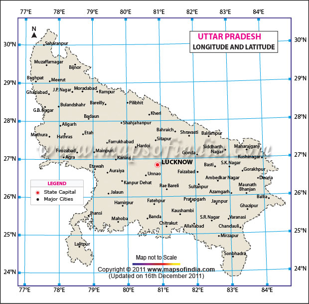
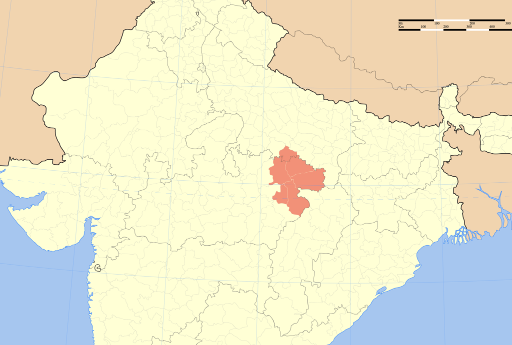
- Uttar Pradesh is a state in northern India. It is located between 23°52’N and 30°24’N latitude and 77°3′ and 84°39‘E longitude.
- The extent of Uttar Pradesh from east to west is 650 km and from south to north is 240 km.
- Uttar Pradesh is the fourth largest state of India after Rajasthan, Madhya Pradesh and Maharashtra. It has a total area of 2,40,928 sq km. equating to 7.33% of the country.
- The state is the representative of rural India and has an urban area of only 2.70% of its total area.
- Uttar Pradesh is the most populous state, with the population close to 20 crores. It is also the fourth most densely populated state after Bihar, West Bengal and Kerala. It has a population density of 828 person per sq. km.
- The Indian Standard Time (IST) is calculated based on 82.5° east longitude passing through Mirzapur of Uttar Pradesh.

Borders/Frontiers
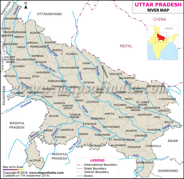
- Uttar Pradesh shares its borders with eight states and one union territory. It also has an international border with Nepal.
- It is bounded by Nepal and Uttarakhand from north, Himachal Pradesh from north-west, Haryana and Delhi from west, Rajasthan from south-west, Madhya Pradesh from south, Chhattisgarh from south-east and Jharkhand and Bihar from east.
- Physical Frontiers
- Uttar Pradesh also has well demarcated physical frontiers. It is surrounded by Shivalik range in the north, Yamuna and Vindhyachal in the west and south-west, and Gandak river in the east.
- The southern frontier of Uttar Pradesh is marked by the presence of plateaus of Bundelkhand and Baghelkhand which extend further into the south.
Bordering States of Uttar Pradesh
| State/UT | Districts | Number of Districts |
|---|---|---|
| Uttarakhand | Saharanpur, Muzaffamagar, Bijnor, Moradabad, Rampur, Bareilly, Pilibhit | 7 |
| Himachal Pradesh | Saharanpur | 1 |
| Haryana | Saharanpur, Shamli, Bagpat, Gautam Buddh Nagar,Aligarh, Mathura | 6 |
| Delhi | Ghaziabad, Gautam Buddh Nagar | 2 |
| Rajasthan | Mathura and Agra | 2 |
| Madhya Pradesh | Sonbhadra, Mirzapur, Prayagraj, Chitrakoot, Banda, Mahoba, Jhansi, Lalitpur, Agra, Etawah, Jalaun | 11 |
| Chhattisgarh | Sonbhadra | 1 |
| Jharkhand | Sonbhadra | 1 |
| Bihar | Maharajganj, Kushinagar, Deoria, Ballia.Ghazipur.Chandauli, Sonbhadra | 7 |
Border with Nepal
- Uttar Pradesh shares approximately 560 km long open border with Nepal touching seven districts -Pilibhit, LakhimpurKheri, Bahraich, Sravasti, Balrampur, Sidhharthnagar, Maharajganj.
- The Government of Uttar Pradesh has decided to build 599 km road of 7 km width along the Uttar Pradesh-Nepal border.
- The State PWD department and SSB have completed the demarcation for this project.
- The state government has also sent the proposal to the Central Home Ministry in this regard.
- This road is considered crucial in the recent India-Nepal border dispute.
Physiography of Uttar Pradesh
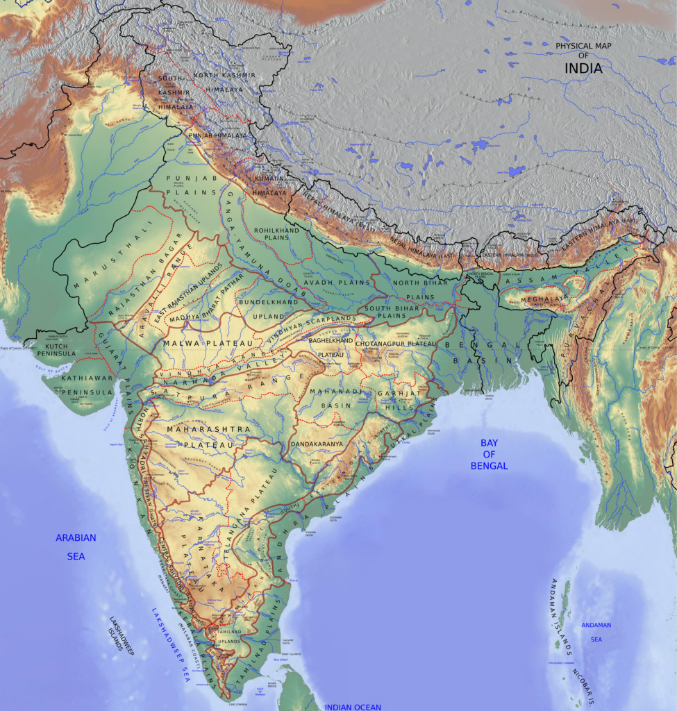
Uttar Pradesh can be divided into following four distinct physical regions for the convenience of study:
- Shivalik foothills in Saharanpur
- Bhabar and Terai region
- Gangetic plains
- Southern Plateau region

Shivalik Foothills
- The northern and northeastern pail of Saharanpur district is marked by the presence of Shivalik hills which form the boundary of state with Uttarakhand.
- These hills are mainly fonned of sedimentary and conglomerate rocks.
- Amsot, Bahansia, Shakambhari, Sahansara and Mohund are important peaks of Shivalik in Uttar Pradesh.
- Mohund pass is known as the gateway to Dehradun.
Bhabar and Terai Region
- Bhabar and Terai region extends parallel to Himalayan foothills and covers the entire length of Uttar Pradesh.
- Bhabar region lies adjacent to Shivalik foothills and Terai is situated south of Bhabhar region.
- The distinct features of Bhabar and Terai are discussed separately:
- Bhabar
- Bhabar region extends from Saharanpur in the west to Deoria in the east.
- It has maximum width of 34 km in the west which decreases in the east.
- The speed of Himalayan rivers decreases due to the gentle slope at the foothill region and rivers deposit large amount of sediments in this region.
- The porosity of the sedimentary deposit region is so high that the small streams and rivers disappear and flow underground in this region.
- Fluvial landforms like alluvial fans and alluvial cones exist in the region. The region is not suitable for agriculture.
- Terai
- The underground streams re-emerge in the Terai region. This region runs parallel to the Bhabar region.
- It is a swampy-marshy region and is infected with mosquitoes. Thick forests, long grasses and rich wildlife exist in this region.
- Parts of Saharanpur, Bijnor, Rampur, Pilibhit, Lakhimpur-Kheri, Behraich, Gonda, Basti, Siddhartha Nagar, Gorakhpur, Maharajganj and Deoria come in the Terai region.
- It used to be 80-90 km in width but a significant part of the region has now been transformed into agricultural land.
- Now, the region is famous for the cultivation of sugarcane, wheat and rice.
- Sal, Semal and Handu are the important tree species of the region.
- The Dundwa range of Shivalik extends into the Terai region in Eastern Uttar Pradesh.
- Bhabar

The Gangetic Plain
- The fertile plain region lies south of Terai region and north of the plateau region. The topography of this region is almost even and suitable for human habitation.
- It is formed by the alluvial deposits brought by Ganga and its tributaries. The direction of the slope in the western region is from north to south whereas north-east to south-west in the eastern region. The slope in the western part is steeper.
- The general elevation of the plain ranges from 80 to 250 m. The plain region dominates the landscape of Uttar Pradesh and covers nearly three fourth of the geographical area of the state.
- This plain is divided into two parts known as Bangar and Khadar based on its structure:
- Bangar
- The Bangar regions are old alluvial plains formed by old alluvium during the middle Pleistocene. These are upland parts where floodwater is unable to reach. This region is characterised by kankar and bhur formations.
- Kankars are calcium nodules formed by capillary actions and bhur are undulating deposits formed due to accumulation of sand brought by the wind. The soil is dark in colour and rich in humus.
- It is coarser and less fertile. The excessive irrigation has led to an increase in salinity of the land which is known as reh or kallar formation.
- Khadar
- Khadar are lowland alluvial deposits. This region is flood-prone and receives fresh alluvial deposits every year.
- The soil is finer and fertile compared to Bangar. The finer soil further makes it more flood-prone. The soil is good for sugarcane, rice, wheat, etc.
Regional division of Gangetic Plains
- The Gangetic plains in Uttar Pradesh are divided into following four parts on the regional basis:
- Ganga-Yamuna Doab – It is the region lying between Ganga and Yamuna rivers. It extends from Saharanpur in the west to Prayagraj in the east. It has three sub-divisions:
- Upper Doab-It extends from Saharanpur to Bulandshahr.
- Middle Doab– It extends from Aligarh to Kannauj and Auraiya.
- Lower Doab– It extends from Kanpur to Prayagraj.
- Rohilkhand Plains – Rohilkhand Plains are situated in the north-western part of Uttar Pradesh. It has Ganga-Yamuna doab to its south and west and Awadh plains in the southeast. Terai region is situated in the north.
- It includes regions of Amroha, Bareilly, Bijnor, Badaun, Moradabad, Rampur, Shahjahanpur, Pilibhit and Sambhal.
- Apart from Ganga, these plains are formed by the Ramganga along with its tributaries.
- Ramganga river divides it into two parts, i.e. western Bangar region and eastern Ramganga Khadar.
- Awadh Plains – The Awadh plains are bounded by Ganga-Yamuna doab to the southeast, Rohilkhand to the northwest, Terai region to the north and Purvanchal plains to the east.
- Awadh Plains includes region of Hardoi, Sitapur, Lucknow, Ayodhya, Amethi, Sultanpur,etc.
- Apart from Ganga, Ghagra and Gomati also drain this plain.
- Purvanchal Plains – It covers regions of Jaunpur, Sant Ravidasnagar, Azamgarh, Varanasi, Gorakhpur, Balia and Ghazipur.
- The northern parts of this plain have been formed by Rapti and Ghaghra rivers. It is given names of Rapti Khadar, Saryupar Maidan and Purabiya Plains from the south to north.
Southern Plateau Region
- Southern plateau region of Uttar Pradesh is the northern extension of the Peninsular Plateau. Its northern boundary is marked by the Ganga and Yamuna rivers.
- The average height of the region is about 300 m. However, the height also reaches 450 m at some places. Hills in Mirzapur and Sonbhadra are approximately 600 m in height.
- It includes Jhansi, Jalaun, Hamirpur, Mahoba, Chitrakoot, Lalitpur, Banda, Meja and Karcchana blocks of Prayagraj, Chakia block of Chandauli and parts of Mirzapur located south of Ganga.
- The general direction of the slope is towards the north-east.
- Chambal, Betwa, Dhasan, Ken etc. are major rivers of the region.
- The southern plateau is divided into three parts.
- Trans-Yamuna region– It includes regions west of the Yamuna in Agra and Mathura districts.
- Baghelkhand Plateau – South-eastern part of Uttar Pradesh has the presence of Baghelkhand plateau.
- It includes Sonabhrdra, Mirzapur, southern parts of Chandauli and Southeastern parts of Prayagraj.
- The Narmada-Son rift valley is situated south of this plateau. It is drained by Son, Karmnasa, Belan, etc. rivers.
- It has Sonpur hills in the north and Ramgarh hills in the south. This is a coal-rich region and Singrauli Basin is situated here. It is also known as Vindhyachal Plateau.
- Bundelkhand Plateau – The plateau extends in the states of Uttar Pradesh and Madhya Pradesh.
- Its boundaries are marked by the Yamuna in the north, Vindhyas in the south, the Chambal in the north-west and Panna-Ajaigarh range in the south-east.


