

- The Influence of Sea Power upon History, 1660–1783 (1890), by Alfred Thayer Mahan, is the founding text of modern naval geopolitics.
- Its claim: national greatness is bound up with the sea, through its commercial use in peace and its control in war.
- Mahan set out six conditions for sea power and stressed strategic positions such as chokepoints, canals and coaling stations.
- China’s and India’s maritime rise, and the Hormuz and Red Sea crises of 2026, have made him current again.
Mahan and His Thesis
The Author
- Mahan (1840–1914) was born at West Point, the son of the instructor Dennis Hart Mahan. He graduated from the US Naval Academy in 1859 and served the Union Navy in the Civil War.
- His first book was The Gulf and Inland Waters (1883). Lectures at the Naval War College, which he twice headed (1886–89, 1892–93), became The Influence of Sea Power.
- A sequel on the French Revolution and Empire (1892) followed. He was also a regular commentator on naval and diplomatic affairs.
The Argument
- The sea as highway: it is “a great highway; or better, perhaps, of a wide common“, on which well-worn trade routes emerge because water carriage is easier and cheaper than land carriage.
- Sea power in the broad sense has two parts: the military strength afloat, and the peaceful commerce and shipping “from which alone a military fleet naturally and healthfully springs”.
- The chain: production creates goods to exchange, shipping carries them, and colonies and posts enlarge and shelter that shipping.
- Command of the sea: the navy’s first task is to win it, by concentrating the fleet for a decisive battle and by blockade, as Britain did to France.
- Peacetime duty: states should expand production and shipping and acquire overseas posts, though he wanted fuelling stations and bases kept few, so as not to drain the home country.
- Method: he derived principles from British history, 1660–1783, and held that they outlast changes in technology.
- What gave control of the sea: strategic locations such as chokepoints, canals and coaling stations, along with measurable fighting power in a fleet.
The Six Conditions
| Condition | What it means | Mahan’s example | Reading for India today |
|---|---|---|---|
| I. Geographical position | No land frontier to defend or covet; a central place on the routes | England over France and Holland | Astride east-west lanes, but with two contested land frontiers |
| II. Physical conformation | Harbours, natural products, climate | Poor Holland driven to sea; rich France not drawn to it | Long coast; few natural deep harbours; fertile interior |
| III. Extent of territory | Length of coast and harbours against population | The blockaded Confederate South | Long coast and island chains to hold |
| IV. Number of population | Those who follow the sea, not the total | England’s reserve of seafarers against France | Large seafarer pool; small merchant fleet |
| V. Character of the people | The tendency to trade | Dutch and English merchants against Spanish gold-seekers | Old ocean trade; long inward turn |
| VI. Character of the government | Sustained policy for navy and commerce | Britain’s landed class; Colbert’s short-lived surge | Maritime policy is recent but rising |
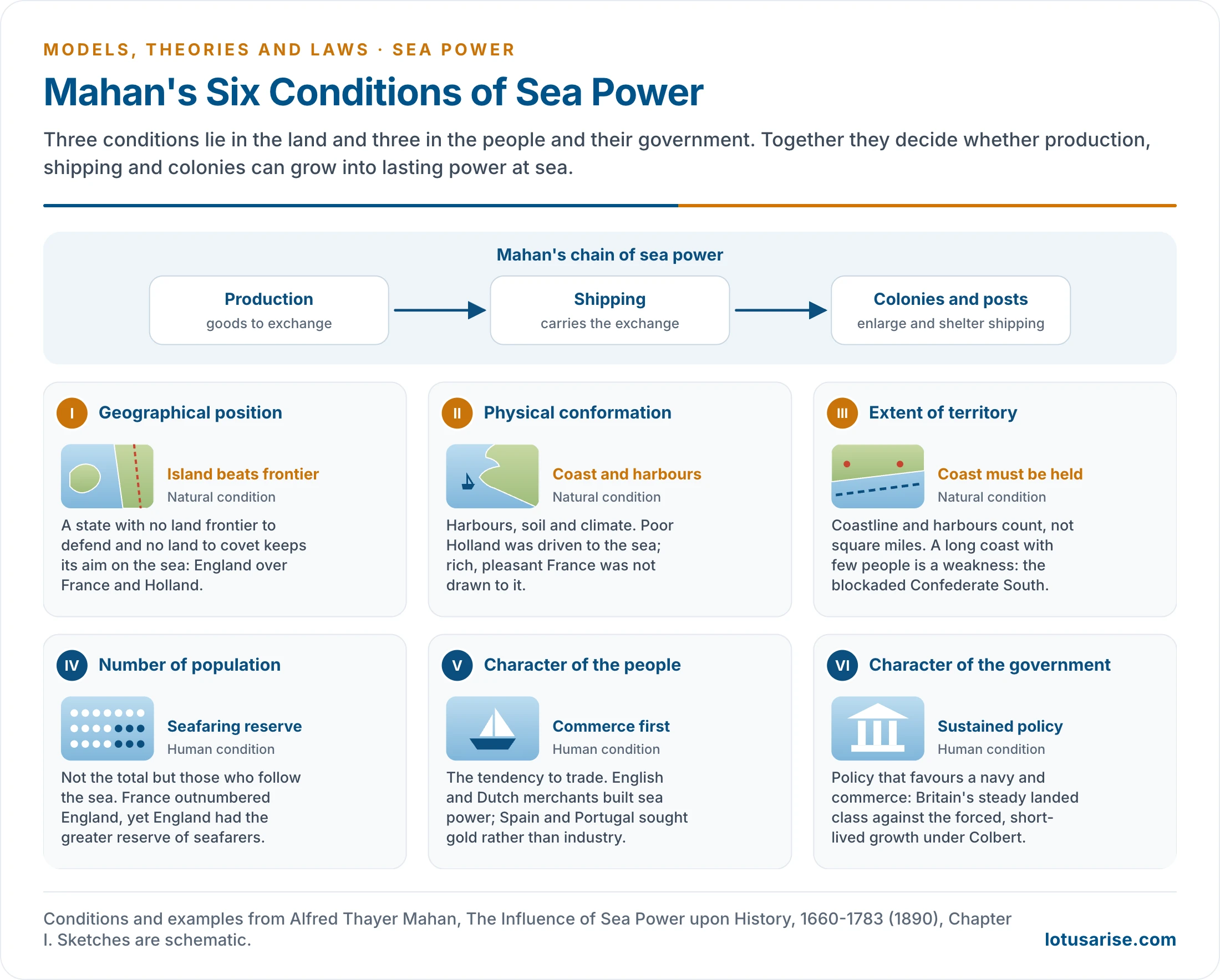
- In short form, the six are an advantageous position; serviceable coasts, abundant resources and a favourable climate; extent of territory; a population large enough to defend it; a society with an aptitude for the sea and commerce; and a government with the will to dominate the sea.
Mahan’s Asia
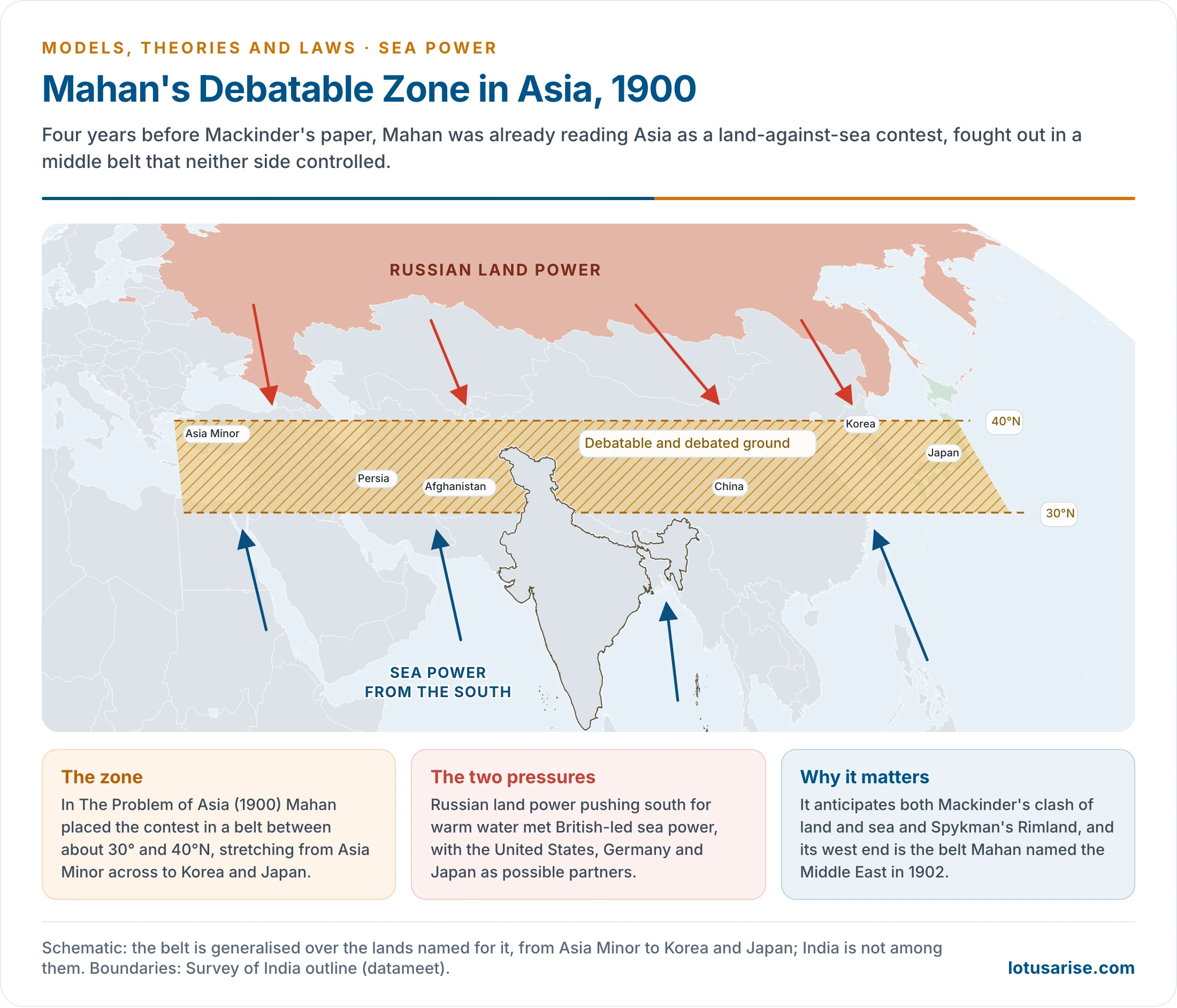
- In The Problem of Asia (1900) he marked a debatable and debated zone between about 30° and 40°N, from Asia Minor across to Korea and Japan, where Russian land power met British-led sea power.
- This anticipates both Halford John Mackinder’s Heartland and Nicholas John Spykman’s Rimland, and Spykman’s rim is closer to this belt than to Mackinder’s crescent.
- In 1902 he used the name Middle East for the region around the Persian Gulf, which guards the route between Suez and India.
- Europe, the Mediterranean and the Middle East form one chain of position: sea control in the Mediterranean protects southern Europe, and it depends on holding the Suez and Gulf approaches at the eastern end. The Second World War’s North African campaigns and the oil politics after it both follow that logic.
His Influence
- The United States: Theodore Roosevelt, a friend from 1888, built a global navy on this reasoning.
- Navies everywhere: the book, which brought him national and international fame, became a “bible” for many of them.
- Germany and Japan: he became a household name in Germany as it built its fleet, and Japan’s doctrine of decisive battle drew on him.
- India: Kavalam Madhava Panikkar’s India and the Indian Ocean (1945), subtitled an essay on the influence of sea power on Indian history, carried the argument to India.
- His principle was that command of the sea in time brings command of the land beside it. Conquerors who came by land were absorbed into India, while the British stayed apart because naval supply lines tied them to home. Japan’s seizure of Singapore and the Andamans in 1942 pointed the same way.
Sea Power in Indian History
- India’s major contacts with the outside world for two millennia ran largely by sea. The record fits Mahan’s chain of production, shipping and posts.
- Early period: Mauryan ports worked the Bay of Bengal, and Kautilya’s Arthashastra provides for sea affairs. The Cholas built a naval power, and the Sumatran empire of Srivijaya traded closely with South India from the 8th to the 11th centuries.
- Arabs and Europeans: Arab traders dominated the Arabian Sea until Vasco da Gama reached Calicut in 1498. European rivalry followed, and Britain’s navy won supremacy, developing Mumbai, Kolkata and Chennai as ports.
- A land-facing interior: before European seamen arrived, no large power had been founded in India from across the water, and north India fell repeatedly to overland conquest. Mahan’s fifth and sixth conditions read this as a long inward turn.
The Indian Ocean as Mahan’s Sea
- A closed north: Asia shuts the ocean on that side, so it has no Arctic outlet. That leaves a limited number of entrances, and India holds a commanding place between them.
- Before 1869 the only contact with the West ran round the Cape of Good Hope. The Suez Canal opened a second way, and the eastern exits lie through Indonesia and south of Australia.
- The vacuum: by the 1960s Britain had lost most of its colonies, and in January 1968 London announced its withdrawal from east of Suez. The United States then built its base on Diego Garcia, and Soviet ships toured the ocean from 1968.
- The geopolitics of the Indian Ocean still turns on these gates and the states around them.
Critique
- Land power: he could not explain the rise of land empires. Mackinder (1904) argued that railways were ending the age of naval advantage, and Paul Kennedy set “Mahan versus Mackinder” (1974) to show sea power waning relatively in the world wars.
- Maritime strategy: Julian Stafford Corbett (Some Principles of Maritime Strategy, 1911) held that sea power works through its effect on land, and that decisive battle is not always the aim.
- The weaker navy: France’s Jeune École favoured torpedo boats and commerce war. Germany’s submarine campaigns gave it force, and later missiles and aircraft made great fleets vulnerable near shore.
- Selective history: one British case, drawn from a century of sail, was made into general law. He neglected diplomacy, finance and land armies.
- Determinism and empire: national character is a weak and loaded category. His thesis also justified colonies and fed the Anglo-German naval race.
- Law: the “wide common” is now divided by the zones of UNCLOS, which guarantee transit passage through straits.
- A false quotation: the line that “whoever controls the Indian Ocean dominates Asia”, often credited to Mahan, is apocryphal. It has no source in his writing.
Chokepoints Today
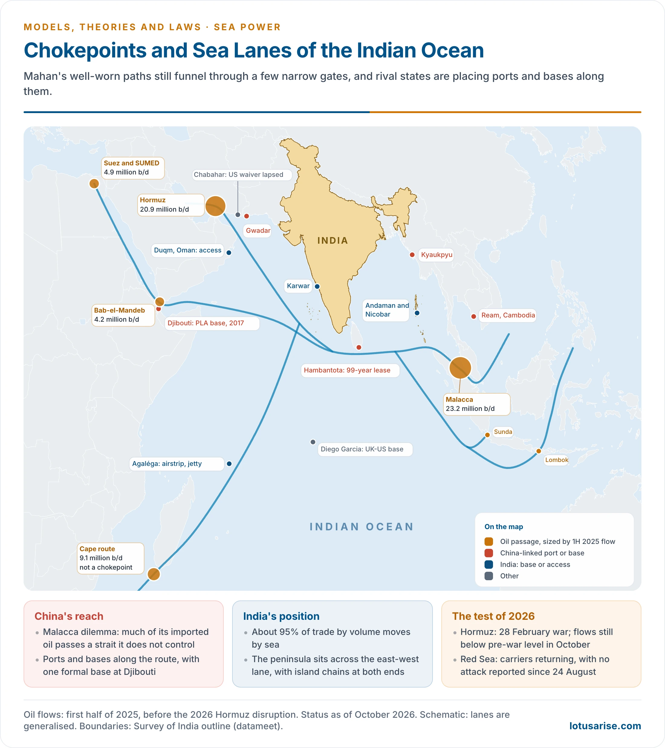
- Mahan’s “well-worn paths” now carry about 80 million barrels of oil a day by sea. World trade funnels through a few narrow gates, which gives leverage to anyone able to threaten them.
| Passage | Oil flow, first half 2025 (million b/d) | Status, October 2026 |
|---|---|---|
| Malacca | 23.2 | Open; the largest oil chokepoint |
| Hormuz | 20.9 | Contested since 28 February 2026; flows below pre-war level |
| Cape of Good Hope | 9.1 | Not a chokepoint; the Red Sea diversion route |
| Suez and SUMED | 4.9 | Recovering; tonnage about 36% below pre-crisis |
| Danish Straits | 4.9 | Open |
| Bab-el-Mandeb | 4.2 | Carriers returning; Houthi threat unresolved |
| Turkish Straits | 3.7 | Open; Black Sea at war |
| Panama | 2.3 | Open |
- 2026 lessons: closing a strait no longer needs a great fleet. Mines, drones and missiles from the shore suffice, as Iran’s campaign shows, which is closer to the Jeune École than to Mahan.
- Bypass has limits: Saudi and UAE pipelines carry only part of the Gulf’s oil.
China’s Maritime Strategy
- The vulnerability: President Hu Jintao named the Malacca dilemma in 2003. Almost half of China’s crude came through Hormuz before the 2026 war, and most of that then passes Malacca.
- Doctrine: the 2015 white paper said “the traditional mentality that land outweighs sea must be abandoned”. It paired near seas defence with open seas protection.
- Fleet: the US counts China’s navy as the world’s largest by number, with over 370 ships and a projected 435 by 2030. The carrier Fujian was commissioned in November 2025, and the Pentagon reports an aim of nine carriers by 2035.
- Positions: a base at Djibouti (2017), upgraded Ream in Cambodia (2025), and ports at Hambantota (99-year lease, 2017), Gwadar and Kyaukpyu. Analysts call this the string of pearls, yet only Djibouti is a formal base.
- Reading: James Holmes and Toshi Yoshihara describe a turn to Mahan (Red Star over the Pacific, 2010). The fit is partial, since China still has long land frontiers, the burden Mahan’s first condition warns of. It leans on coast guard and missiles in the South China Sea, where the 2016 award stands unaccepted.
India’s Maritime Strategy
- Stakes: about 95% of India’s trade by volume and 70% by value moves by sea (PIB, 2024).
- Vision: SAGAR (2015) widened to MAHASAGAR (March 2025), linking trade, capacity building and mutual security across the Global South. The Navy followed with IOS Sagar and the AIKEYME exercise with African navies in April 2025.
- Positions: Project Seabird at Karwar, a new base at Minicoy (2024), the Andaman and Nicobar Islands, access at Duqm in Oman, and the airstrip and jetty at Agaléga (2024). The Great Nicobar transhipment port at Galathea Bay, notified as a major port on 4 September 2024, lies close to the east-west route.
- Sea-based deterrent: three ballistic missile submarines, from INS Arihant (2016) to INS Aridhaman, commissioned at Visakhapatnam on 3 April 2026.
- Ports: Vizhinjam in Keralam (Kerala), in commercial operation since December 2024, handled about 1.3 million TEU in 2025-26, nearly all of it transhipment. Vadhavan in Maharashtra is being built as a further major port.
- Hormuz test, 2026: the Navy has kept Operation Sankalp in the Gulf of Oman since 2019, and in March 2026 it sent two task forces under Operation Urja Suraksha to escort India-bound ships.
- About 70% of crude imports were then routed outside Hormuz, against 55% earlier (Petroleum Minister, 12 March 2026). LPG proved the weak link: 60% is imported, and about 90% of that came through the strait.
- Limits: a two-front land burden, a small flag fleet of 1,530 ships (2023), since grown to 1,592 ships of 14.02 million gross tonnes (2025), and nearly 75% of transhipped cargo handled abroad. Chabahar has been in doubt since the US waiver ended on 26 April 2026, and the Chagos treaty, which would confirm the Mauritian sovereignty India supports, is stalled by US opposition.
- Partners and base: the Quad’s surveillance initiative of May 2026 adds reach in the contested Indian Ocean realm, while India’s sea ports remain the home base Mahan would look to first.
| Point | China | India |
|---|---|---|
| Position | Boxed in by island chains; must exit through straits | Central in the Indian Ocean; open to the lanes |
| Core fear | Interdiction at Malacca | Hormuz supply; Chinese presence in the region |
| Fleet aim | Blue water; nine carriers by 2035 | Preferred security partner and first responder |
| Bases | Djibouti, plus commercial ports | Access agreements; island territories |
| Land burden | Long frontiers | Pakistan and China fronts: Pakistan-occupied Kashmir and China’s illegal occupation of Aksai Chin |
Relevance Today
- Still valid: trade rides the sea, navies protect it, and position counts. The commercial base he stressed explains China’s rise better than ship numbers alone.
- Revised: shore-based missiles, drones, sanctions and insurance now shape the sea, and law limits claims to it. Command of the sea is more often contested and local than absolute.
- For India: the six conditions read as a checklist, in which position is a gift while shipping, ports and sustained policy are still to be built.
Previous Year Questions
1996‘Without the Mediterranean, Europe could not be held, without the Middle East the Mediterranean could not be held’; Discuss.




