Disaster
The United Nations International Strategy for Disaster Reduction (UNISDR) (2009) defines disaster as:
“A serious disruption of the functioning of a community or a society involving widespread human, material, economic or environmental losses and impacts, which exceeds the ability of the affected community or society to cope using its own resources.”
As per the Disaster Management Act 2005, “Disaster” means a catastrophe, mishap, calamity or grave
occurrence in any area, arising from natural or manmadẹ causes, or by accident or negligence which results in substantial loss of life or human suffering or damage to, and destruction of, property, or damage to, or degradation of, environment, and is of such a nature or magnitude as to be beyond the coping capacity of the community of the affected area. UNISDR considers disaster to be a result of the combination of many factors such as
- exposure to hazards;
- conditions of vulnerability that are present, and
- insufficient capacity or measures to reduce or cope with the potential negative consequences.
Disaster impacts everyone differently. Some of the them are as under:
| Individual | Psychological and emotional trauma. Injuries, disease and other negative effects on human physical, mental and social well-being |
| Physical Infrasturctural | Damage to property and destruction of assets |
| Human Infrasturctural | Loss of life. |
| Governance | Loss of services and administration problems |
| Social | Social and economic disruption – Worst hit are Women, Children and old age as they are most vulnerable groups. |
| Environmental | Environmental degradation |
Disaster Matrix
Identification and classification of disaster is being considered as an effective and scientific step to deal
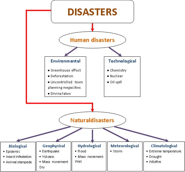
promptly and efficiently with the disaster. Primarily disasters are triggered by natural hazards or human induced, or result from a combination of both. In particular, human-induced factors can greatly aggravate the adverse impacts of a natural disaster. These disaster situations and their specific features are captured in a ‘Disaster management matrix’ shown in Table.

Classification of Natural Hazards
The widely accepted classification system classifies disasters arising from natural hazards into five major categories:
- Geophysical: Geological process that may cause loss of life, injury or other health impacts, property damage, loss of livelihoods and services, social and economic disruption, or environmental damage. Hydrometeorological factors are important contributors to some of these processes.
- Hydrological: Events caused by deviations in the normal water cycle and/or overflow of bodies of water caused by wind set-up.
- Meteorological: Events caused by short-lived/small to meso-scale atmospheric processes.
- Climatological: Events caused by long-lived meso to macro-scale processes.
- Biological: Process or phenomenon of organic origin or conveyed by biological vectors,including exposure to pathogenic micro-organisms, toxins and bioactive substances that may cause loss of life, injury, illness or other health impacts, property damage, loss of livelihoods and services, social and economic disruption, or environmental damage.
A brief description of the five major categories of the disasters arising from natural factors with the subcategories is given in the table.
Classification of Disasters and its Consequences
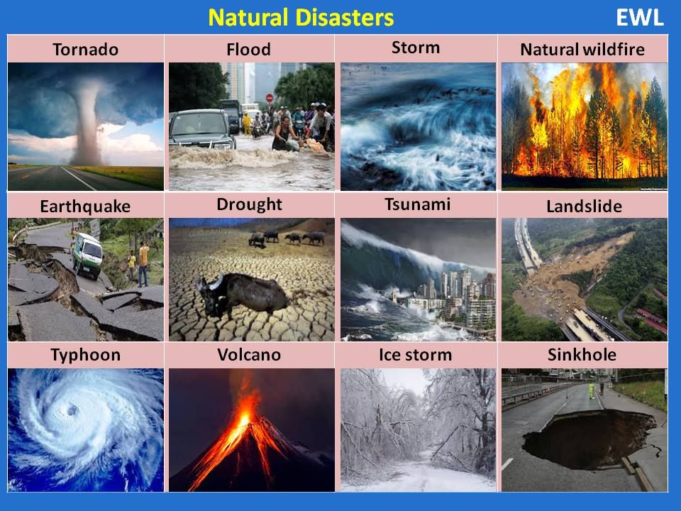
Geophysical
Earthquake/Mass movement of earth materials
- Landslide following earthquake;
- Urban fires triggered by earthquakes;
- Liquefaction – the transformation of (partially)water-saturated soil from a solid state to a liquid state caused by an earthquake.
- Mass movement of earth materials, usually down slopes.
- Surface displacement of earthen materials due to ground shaking triggered by earthquakes.
Volcano
- Surface displacement of earthen materials due to ground shaking triggered by volcanic eruptions
- A type of geological event near an opening/vent in the Earth’s surface including volcanic eruptions of lava, ash, hot vapour, gas, and pyroclastic material.
- Ash fall; Lahar – Hot or cold mixture of earthen material flowing on the slope of a volcano either during or between volcanic eruptions;
- Lava Flow
- Pyroclastic Flow – Extremely hot gases, ash, and other materials of more than 1,000 degrees Celsius that rapidly flow down the flank of a volcano (more than 700 km/h) during an eruption.
Tsunami
- A series of waves (with long wavelengths when traveling across the deep ocean) that are generated by a displacement of massive amounts of water through underwater earthquakes, volcanic eruptions or landslides.
- Tsunami waves travel at very high speed across the ocean but as they begin to reach shallow water, they slow down and the wave grows steeper .
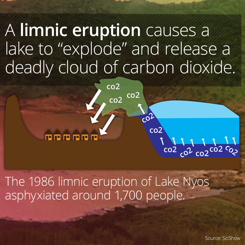
Limnic eruption / lake overturn
- Dissolved CO2 suddenly erupts from deep lake waters, forming a gas cloud suffocating wildlife, livestock, and humans.
- Scientists believe earthquakes, volcanic activity, and other explosive events can serve as triggers for limnic eruptions. Lakes in which such activity occurs are referred to as limnically active lakes or exploding lakes. Some features of limnically active lakes include:
- CO2-saturated incoming water
- A cool lake bottom indicating an absence of direct volcanic interaction with lake waters
- An upper and lower thermal layer with differing CO2 saturations
- Proximity to areas with volcanic activity
- Lanke Monoun (Cameroon)
- Now there is concern about lake Kivu (Border of Rwanda in Congo)
Hydrological
Floods, Landslides, Wave action
- Avalanche: A large mass of loosened earth material,snow, or ice that slides, flows or falls rapidly down a mountainside under the force of gravity.
- Coastal Erosion: The temporary or permanent loss of sediments or landmass in coastal margins due to the action of waves, winds, tides, or anthropogenic activities
- Coastal flood: Higher-than-normal water levels along the coast caused by tidal changes or thunderstorms that result in flooding, which can last from days to weeks
- Debris Flow, Mud Flow, Rock Fall: Types of landslides that occur when heavy rain or rapid snow/ice melt send large amounts of vegetation, mud, or rock down slope by gravitational forces.
- Flash Flood Hydrological: Heavy or excessive rainfall in a short period of time that produce immediate runoff, creating flooding conditions within minutes or a few hours during or after the rainfall
- Flood Hydrological: A general term for the overflow of water from a stream channel onto normally dry land in the floodplain (riverine flooding), higher-than normal levels along the coast and in lakes or reservoirs (coastal flooding) as well as pending of water at or near the point where the rain fell (flash floods).
- Wave Action: Wind-generated surface waves that can occur on the surface of any open body of water such as oceans, rivers and lakes, etc. The size of the wave depends on the strength of the wind and the travelled distance (fetch).
Meteorological
Hazard caused by short-lived, micro- to meso-scale extreme weather and atmospheric conditions that may last for minutes to days:
- Cyclone, Storm Surge, Tornado, Convective Storm, Extratropical Storm, Wind
- Cold Wave, Derecho
- Extreme Temperature, Fog, Frost, Freeze, Hail, Heat-wave
- Lightning, Heavy Rain
- Sand-Storm, Dust-Storm
- Snow, Ice, Winter Storm, Blizzard.
Climatological
Unusual, extreme Weather conditions related to longlived, meso- to macro-scale atmospheric processes ranging from intra-seasonal to multidecadal (long-term) climate variability
- Drought
- Extreme hot/cold conditions Forest/Wildfire Fires Glacial Lake Outburst Subsidence
Biologcal
Exposure to germs and toxic substances:
- Epidemics: viral, bacterial, parasitic, fungal, or prion infections
- Insect infestations
- Animal stampedes
Natural Disasters and Hazards in India
Earthquake
Earthquake is the shaking of the earth’s crust caused by sudden release of energy in its interior. Its sudden impact provide very less response time and make its prediction impossible.
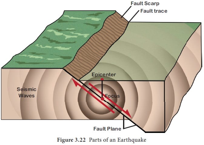
Causes: It is a well known fact that Indian Plate is moving at a speed of 1 cm per year towards the north and North Eastern direction and this movement of plates is being constantly obstructed by The Eurasian plate from the north. As a result of this, both the plates are said to be locked with each other resulting in accumulation of energy at different points of time. Excessive accumulation of energy results in building up of stress which ultimately leads to the breaking up of the lock and sudden release of energy causing earthquakes along the Himalayan arch.
The emergence of a fault line and energy buildup along the fault line represented by the river Bhima and the possible breaking down of the Indian Plate is also one of the reason for some of the recent earthquakes.
Regions of Earthquake Zones
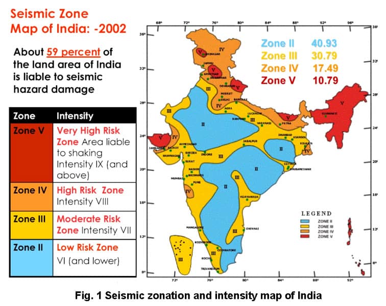
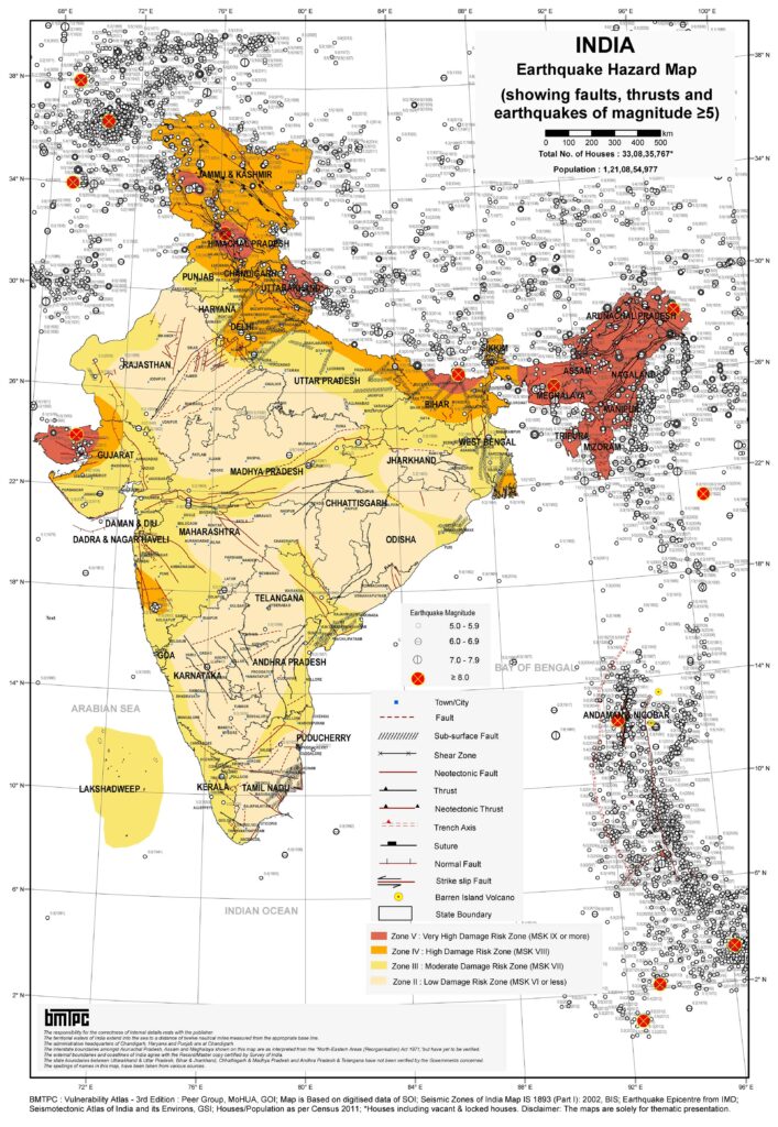
Nearly 60 percent of India’s territory is vulnerable to earthquakes. Some of the most vulnerable states are Jammu and Kashmir, Himachal Pradesh, Uttarakhand, Sikkim and Darjeeling and subdivision of West Bengal and all the seven states of the northeast. However for a better understanding, they are divided into following earthquake zones which is represented by the map given below:
Consequences of Earthquakes
- Surfaces seismic waves produce fissures on the upper layer of the earth’s crust through which water and other volatile materials gush out, inundating the neighbouring areas.
- Earthquakes are also responsible for landslides.
- The earthquakes cause obstructions in the flow of rivers and channels resulting in the formation of reservoir.
- Sometimes rivers also change their course causing floods and other calamities in the affected areas.
Earthquake Hazard Mitigation
It is not possible to prevent the occurrence of an earthquake and hence the better option is to prepare for the disaster and have some mitigation strategy rather than curative measures such as:
- Establishing earthquake monitoring centres for regular monitoring and fast dissemination of information among the people in the vulnerable areas.
- Preparing a vulnerability map of the country and dissemination of vulnerability risk information among the people.
- Educating people about the ways and means minimising the adverse impact of disasters.
- Modifying the house types and building designs in the vulnerable areas. Also discouraging construction of high rise buildings, large Industrial establishments and big urban centre.
- Making it mandatory to adopt earthquake resistant design and use light materials in major construction activities in the vulnerable areas.
- Making use of indigenous technical knowledge and locally available materials in the construction of
earthquake -resistant houses like the Bhongas in the Kutch (Gujarat), Dhajji Diwari (Jammu & Kashmir) and Ekra constructions made of bamboo in Assam.
Tsunami
Tsunamis can be triggered off by an underwater earthquake, a volcanic eruption, a submarine rock slide, or rarely by an asteroid or meteorite crashing into water from space. Most Tsunamis are caused by underwater earthquakes, but not all underwater earthquakes cause tsunamis.
Tsunami is a series of ocean waves that sends surges of water, sometimes reaching height over 30 meters on the land. These walls of water can cause widespread destruction when they crash ashore.
Tsunami Vulnerable Areas
Tsunamis are frequently observed along the Pacific Ring of Fire, particularly along the coast of Alaska, Japan, Philippines, and other islands of Southeast Asia, Indonesia, Malaysia, Myanmar, Sri Lanka and India. The tsunami that occurred on 26th December 2004 caused great damage to India especially in the regions of Tamil Nadu, Puducherry, Kerala, Andhra Pradesh and Andaman and Nicobar Islands.
Areas of Tsunami
Tsunamis are frequently observed along the Pacific Ring of Fire , particularly along the coast of Alaska, Japan, Philippines, and other island of Southeast Asia Indonesia ,Malaysia .Myanmar, Sri Lanka and India. India has been greatly affected by tsunami specially in the region of Tamil Nadu, Puducherry, Kerala, Andhra Pradesh and Andaman and Nicobar Islands.
Impact of Tsunami
On reaching the coast ,the tsunami waves release enormous energy stored in them and water flows turbulently on to the land destroying port cities and towns, structures, buildings, and other settlements Since the coastal areas are densely populated the world over and are also centres of intense human activity ,the loss of life and property is likely to be much higher by Tsunami as compared to other natural Hazard in the coastal areas.
Tsunami Hazard Mitigation
It is not possible to prevent a the occurrence of tsunami. However some measures can be taken to reduce the damage caused by Tsunami. Some of the measures are :
- Provide a shelf of comprehensive solutions for improving the vulnerability reduction of coastal areas like development of bioshield, like mangrooves and shelter belt plantation.
- Chalk out strategies for strengthening education, research and documentation for strengthening tsunami risk management preparedness measures by academic and professional institutes.
- Early warning accompanied by thorough evaluation of risk zones. The Indian Tsunami Early Warming Centre (ITEWC), which is based at and operated by Indian National Centre for Ocean Information Services (INCOIS), Hyderabad has all necessary advisories to India as well as to Indian Ocean Countries (24 countries).
- Land use zoning can be made a function of hazard maps which report expected heights of tsunami likely to occur. Houses and other buildings can be moved to higher ground and new construction banned in the principal risk areas.
- Breakwaters can be constructed to weaken the approaching waves. There is not a single method to control and mitigate the Tsunamis. Tsunamis can be predicted and even after that they can damage the habitation. Environmental methods and means are the best and the most sustainable. But the best strategy for protecting a coast against Tsunamis is to use an appropriate mixture of the various measures and methods of Tsunami control.
Tropical Cyclones
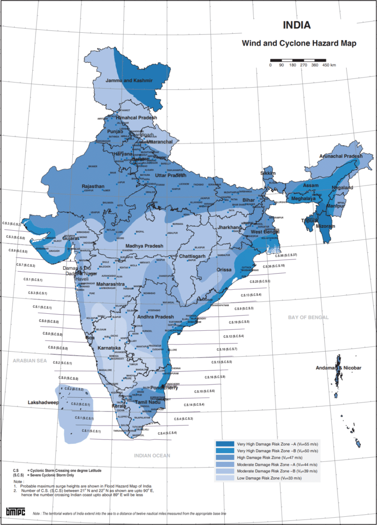
Tropical cyclones are intense low pressure areas confined to the area lying between 30 degree north and 30 degrees South latitude. Tropical cyclone and Hurricane is like a heat engine that is energized by the release of latent heat on account of the condensation of moisture that the wind gathers after moving over the oceans and seas.
Initial Conditions for Emergence of Tropical Cyclone
- Large and continuous supply of warm and moist air that can release enormous latent heat.
- Strong coriolis force that can prevent filling of low pressure at the centre.
- Unstable condition through the troposphere that creates local disturbances around which cyclone develops.
- Finally absence of strong vertical wind wedge which disturbs the vertical transport of latent heat.
Consequence of Tropical Cyclone
The coastal areas are often struck by severe cyclonic Storms with an average velocity of 180 km per hour. Often this results in the abnormal rise in the sea level known as storm surge. This results in inundation of human settlements, agricultural fields, damaging crops and destruction of structures created by human beings.
Tropical Cyclone Hazard Mitigation
- Green belt plantation along the coastal line in a scientific interweaving pattern can reduce the effect of the hazard.
- Land use control should be designed so that least critical activities are placed in vulnerable areas.
- Structures need to be built to withstand wind forces.
- Torrential rains, strong wind and storm range leads to flooding in the cyclone affected areas. There are possibilities of landslides too. Flood mitigation measures could be incorporated.
- Cyclone shelter: are buildings or safe shelter in the coastal villages, which could withstand, the intensity of the cyclone and storm surges.
- Efficient cyclone forecast and warning services. Over the years because of efficient forecasting and administration there is reduction in the loss of property and lives caused by cyclones in India.
| Year | Cyclone | Deaths | Damage (in$) |
|---|---|---|---|
| 1999 | BOB 06 | 10000 | 400 crore |
| 2013 | Phalin | 45 | 70 crore |
Floods
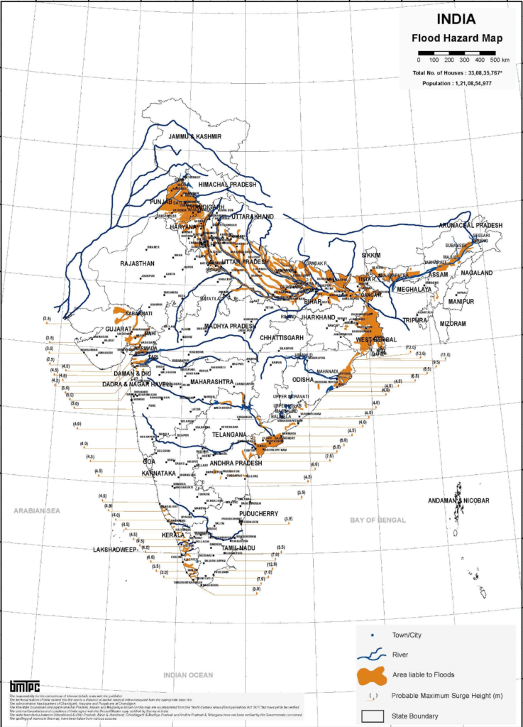
Flooding is a condition of inundation of land and human settlements by the rise of water in the channels and its spillover is present. Floods are relatively slow in occurrence and often occur in well identified regions and within expected time in a year.
Causes of Floods
Floods occur when
- Water in the form of a surface runoff exceeds the carrying capacity of the river channels and streams and flows into neighbouring low-lying floodplains.
- Storm surges.
- There is High intensity rainfall for a considerably longer time period.
- Melting of ice and snow.
- Reduction in the infiltration rate and presence of eroded material in the water due to higher rate of soil erosion.
Role of Human being in Causing Floods
Unlike other natural disasters, human beings play an important role in causing floods. This may be attributed to:
- Indiscriminate deforestation;
- Unscientific agricultural practice
- Disturbances along the natural drainage channel
- Colonization of floodplains and river beds etc.
Flood Prone Areas in India
The states that are usually affected by the floods include Assam, West Bengal, Bihar, Andhra Pradesh, Punjab , Haryana, and Gujarat along with north eastern states. Sometimes Tamil Nadu experiences flooding during November to January due to the retreating monsoon.
Consequences of Floods
- Serious damage to physical infrastructure such as roads, rails, bridges and human settlements along with the agricultural land have serious consequences on the national economy and Society
- Millions of people are rendered homeless and spread of disease like cholera, gastroenteritis Hepatitis and other water borne diseases spread in the flood affected areas.
Control Measures of Floods
Following are the few measures which shall be taken to control floods:
- Construction of flood protection embankments in the flood prone areas.
- Construction of dams
- Afforestation
- Flood Plain zoning to regulate land use in the flood plain in order to respect the damage due to floods.
- Discouraging major construction activities in the upper reaches of most of the flood creating rivers
- Removal of human encroachment from the river channels and depopulating the flood plains.
Over 40 million hectares (12 per cent of land) is prone to floods and river erosion.
Urban Floods
Urban floods occur when weather phenomena delivers more precipitation than the capacity of (Urban) drainage basin to readily absorb or transfer it. Example Chennai Floods caused by heavy rainfall due to retreating monsoon. Unplanned development and encroachment of sprawling habitations alongside rivers and watercourses have impeded the natural flow of streams. As a result of this, the runoff has increased causing urban floods. Example floods in Gurugram.
Causes of Urban Floods:
- According to Intergovernmental Panel on Climate Change (IPCC) with the occurrence of Global Warming the intensity of precipitation and cyclones has increased leading to heavy rainfall.
- As per NASA study due to urban Heat Island there occurs low pressure zone over Chennai and Pune. Thus pushes clouds upwards and lead to high intensity rainfall.
- Natural Channel of streams encroached by buildings, bridges, roads etc For example encroachment in Jhelum basin caused floods in Srinagar.
- Artificial Channels have inadequate capacity to drain the water during heavy rainfall. Also urban local bodies lack sufficient staff and tools to keep these drains desilted and clean.
- Desiltation of river is not done regularly. Heavy siltation in Adyar river has caused floods in Chennai.
Mitigation Strategies for Urban Floods :
Urban flooding has localized impacts on commercial industrial, business, residential and institutional locations. Disruption of water supply, sewerage, power supply, transport and communication system is common. The following three phases of disaster management can be
applied to mitigate the impact of urban floods:
(a) Pre-Monsoon Phase (Preparedness): Familiarization of the stakeholders (training of municipality staff), identification of teams for maintaining the drains and roads.
(b) During Monsoon Phase (Early Warning and Effective Response): If involves giving qualitative and quantitative warnings based on the intensity of rainfall to various agencies to take preventive measures. The response phase focuses primarily on emergency relief. Saving lives, providing first aid, minimizing and restoring damaged systems (communication and transportation), meeting the basic life requirements of those impacted by disaster (food,water and shelter).
(c) Post-Monsoon Phase: Restoration and rehabilitation phase includes establishment of a programme to restore both the disaster site and the damaged materials to a stable and usable condition.
Drought
There is no globally adopted operational definition for drought applicable to all contexts. However for a better understanding the term drought is applied to an extended period when there is a shortage of water availability due to inadequate precipitation, excessive rate of evaporation and over utilisation of water from the Reservoir and other storages including the groundwater.
Drought is a phenomenon that is widely considered as a ‘creeping disaster’ whose onset, end, and severity are difficult to determine. Unlike the suddenly occurring disasters, a drought may develop very slowly over several months affecting very large geographical area without causing little or no structural damage. The impacts depend on natural conditions, socio-economic situation, and the kind of land and water resources as well as the use patterns in the affected region.
Types of Drought
- Meteorological Drought: It is a situation when there is a prolonged period of inadequate rainfall marked with mal- distribution of the same over time and space.
- Agricultural Drought: It is also known as soil moisture drought. It is characterized by Low soil moisture that is necessary to support the crops thereby resulting in crop failure. Moreover if an area has more than 30% of its gross cropped area under irrigation the area is excluded from the drought prone category
- Hydrological Drought: It results when the availability of water in different storage and reservoir like aquifers, lakes, reservoir etc falls below what the precipitation can replenish.
- Ecological Drought: When the productivity of a natural ecosystem fails due to shortage of water and as a consequence of ecological distress damages are induced in the ecosystem.
Drought Situations
The IMD recognizes five drought situations:
• Drought Week: When the weekly rainfall is less than half of the normal.
• Agricultural Drought: When four drought weeks occur consecutively during mid-June to September
• Seasonal Drought: When seasonal rainfall is deficient by more than the standard deviation from the normal
• Drought Year: When annual rainfall is deficient by 20 percent of normal or more, and
• Severe Drought Year: When annual rainfall is deficient by 25 to 40 percent of normal or more.
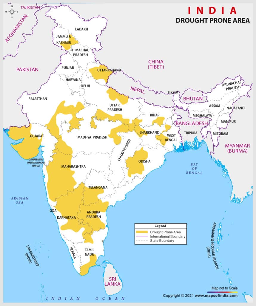
Drought Prone Areas in India
On the basis of severity of droughts, India can be divided
into the following regions:
• Extreme Drought Affected Areas: It includes parts of Rajasthan particularly areas to the west of Aravalli hills, that is marusthali and Kutch region of Rajasthan falls in this category. Other areas include districts like Jaisalmer and Barmer from the Indian desert that receive less than 90 mm average annual rainfall.
• Severe Drought Prone Areas: Parts of eastern Rajasthan, most parts of Madhya Pradesh, Eastern parts of Maharashtra, interior parts of Andhra Pradesh and Karnataka plateau, Northern parts of interior Tamil Nadu and Southern parts of Jharkhand and interior Orissa are included in this category.
• Moderate Drought Affected Areas: Northern parts of Rajasthan Haryana, Southern districts of Uttar Pradesh, the remaining parts of Gujarat, Maharashtra except konkan, Jharkhand and Coimbatore plateau of Tamilnadu and interior Karnataka included in this category.
Consequences of Drought
Droughts have cascading effects on various aspects such as:
- Crop failure,
- Shortage of water which leads to large scale death of cattle and other animals.
- Migration of human and livestock
- Scarcity of water compels people to consume contaminated water resulting in the speed of many water borne diseases.
Mitigation of Droughts
Some of the following steps can be taken to mitigate droughts::
- Provision for the distribution of safe drinking water.
- Medicines for the victims
- Availability of fodder and water for the cattle
- Shifting of the people and their livestock to safer places
Long Term Measures to Control Drought
- Identification of groundwater potential in the form of aquifers.
- Transfer of river water from surplus to the deficient areas.
- Rainwater harvesting.
- Interlinking of rivers and construction of reservation and dams.
- Remote sensing and satellite imageries can be useful in identifying the possible river basin and in identifying the groundwater potential.
- Dissemination of knowledge about drought resistant crops at proper training to practice the same can be some of the long-term measures that will be helpful in drought mitigation.
Drought Crisis Management Plan
The NDMA manual sets out four important measures that a state government should take at the time of drought, with the help of Union government. These are:
- Mahatma Gandhi National Rural Employment Guarantee Act (MGNREGA) to provide immediate employment.
- Strengthening of public destribution system to provide food and fodder.
- The government should either waive off or defer farmer loans and arrange for crop loss compensation.
- Recharge ground water through check dams and providing pipeline water and other irrigation facilites.
Landslides
The term ‘landslide’ includes all varieties of mass movements of hill slopes and can be defined as the downward and outward movement of slope forming materials composed of rocks, soils, artificial fills or combination of all these materials along surfaces of separation by falling, sliding and flowing, either slowly or quickly from one place to another. Landslides are largely controlled by highly localised factors. Hence, gathering information and monitoring the possibilities of landslides is not only difficult but also immensely cost intensive.
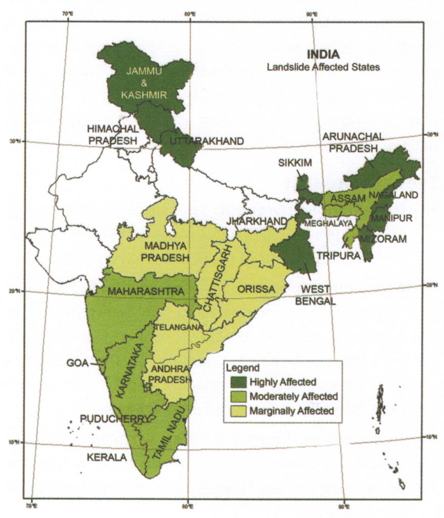
Landslide Vulnerability Zones
1. Very High Vulnerability Zone: This include:
- Highly unstable and relatively young mountainous areas in the Himalayas and Andaman and Nicobar.
- High rainfall regions with steep slopes in the Western Ghats and Nilgiris.
- The North Eastern regions along with areas that experience frequent ground shaking due to earthquakes and areas of human activities.
2. High Vulnerability Zone:
Areas that have almost similar condition to those included in the very high vulnerability zones are also included in this category. The only difference between these two is the combination, intensity and frequency of the controlling factors. All the Himalayan states and the states from North Eastern region except the plains of Assam are included in the high vulnerabilities zone
3. Moderate to low Vulnerability Zone:
- Areas receive less precipitation such as TransHimalayas areas of Ladakh and Spiti,.
- Low population areas of Aravali.
- Rain Shadow areas in the Western and Eastern Ghats and Deccan Plateau.
Consequences of Landslides
Landslides have relatively small and localised area of direct influence but the consequences may be far reaching such as:
- Diversion of river courses due to landslides can also lead to flood and loss of life and property.
- It also makes spatial interaction difficult risky as well as costly which in turn adversely affect the developmental activities of the areas.
Landslides Hazard Mitigation
- Adopt area specific measures
- Restriction on construction and other developmental activities such as roads and dams
- Limiting agriculture to valleys and areas with moderate slopes
- Control on the development of large settlements in the high vulnerability zones
- Promoting large scale afforestation programs
- Construction of bunds to reduce the flow of water
Human Induced Disasters
Chemical (Industrial) Disaste
Due to the regional concentration of chemical companies in certain pockets, the chemical hazard has increased many folds. The growth of chemical industries has led to an increase in the risk of occurrence of incidents associated with hazardous chemicals. The common causes for chemical accidents are:
- Deficiencies in safety management systems or human errors,
- Natural calamities or
- Mishaps or failures in industry
Chemical/industrial accidents are significant and have long term impact on the community and environment. It leads to injuries, pain, suffering, loss of lives, damage to property and environment. Hence, a robust plan and mitigation measure needs to be adapted to overcome the hazard.
Nuclear and Radiological Disaster
A nuclear disaster is caused due to:
- An extraordinary release of radioactive material or radiation in the operation of nuclear reactors
- Explosion of a Radiological Dispersal Device (RDD) or Improvised Nuclear Device (IND).
- Explosion of a nuclear weapon.
- It is accompanied with a sudden release of harmful radiations or radioactive materials or both together into the environment.
However, nuclear emergencies can still arise due to factors beyond the control of the operating agencies from human error like system failure, sabotage,extreme natural events like earthquake, cyclone, flood, tsunami or a combination of these. To counter this, proper emergency preparedness plans must be in place so that there is minimum loss of life, livelihood, property, and impact on the environment.
Fire Risks
Fires in Buildings
India often sees death due to fires in buildings. On an average, India, suffers from death of more than 20,000 people annually. Most of these deaths could be prevented, provided we take proper steps in preventing the fire. Inadequate data on these losses does not make it easy for policy makers to come up with fire mitigation policies. Oxygen leaks, especially in hospitals are also one of the causes of fires in building.
Numerous incident of fires have been observed, especially during the time of Diwali due to illegal manufacturing and storage of firecrackers at several places. Recently a horrific fire at a Hotel in Karol Bagh, Delhi has killed 17 people. It was mainly due to violation of fire safety norms.
Measures to Prevent Fire Accidents
- Regular inspection and timely maintenance of defective equipment
- Comprehensive Fire Safety Audit
- Enhancement of existing infrastructure with advanced technology & well trained fire-fighters
- Dedicated helpline to reduce response time- mapping of cities using color coded zones based on their level of vulnerability.
- Strict adherence to Standard Operating Procedures through proper training of concerned staff.
- Training and participation of staffs and officials in fire safety drills at all public and private work places, schools, educational institutions.
- Encouraging people to participate in mock fire drills to ensure there is no panic during adverse situations of fire-incidents.
- Better facilities in hospitals through quick medical aid at the nearest hospital.
- Construction of explosion and fire resistant buildings in future.
Forest Fires
Forests are vulnerable to fire. Their vulnerability varies from place to place depending upon the type of vegetation and the climate. According to Global Forest Watch, India witnessed a 125% increase in forest fires in just two years (2015-17). Also about half of India’s forests are prone to fire.
Cause of Forest Fires
Forest fires are caused by Natural as well as manmade causes.
Natural Causes: Lightning sets trees on fire, high atmospheric temperature and dryness makes forest prone to fire. Wind speed is the biggest reasons of fires in Bamboo forests.
Manmade Causes:
- 90% of forest fires are man made
- Large scale expansion of Chir-pine forests in Flim alayan mountains. The dry leaves of Chir trees are highly inflammable and catch fire easily.
- Fire is caused when a source of fire like naked flame, cigarette or bidi, electric spark or any source of ignition comes into contact with inflammable material.
- Shifting cultivation in the North Eastern regions of India and in parts of the states of Odisha and Andhra Pradesh.
- To conceal illegal timber cutting, the forest are deliberately set on fire by timber mafias.
Measures to Prevent Forest Fires
- Capacity development of forest departments’ officials at different levels (national, regional and local) to reduce the vulnerability of Indian forests to fires.
- Creating Forest fire manuals for field staff suggesting them ways to detect and report forest fires.
- Incorporation of guidelines and responsibilities of different role players and other stakeholders for a
- systematic management of forest fire.
- Mechanism to assess and monitor forest fire risks and increase sustainable application of warning systems.
- Using indigenous knowledge and techniques to detect and suppress forest fire.
- Making use of technology through research to reduce instances of forest fires.
- Promotion of natural broad leaf trees in place of Chir Pine trees.
- Joint forest management: Local participation of tribal people and farmers need to be encouraged example Van Panchayats.
Railway Accidents
Rail accidents in India have become a regular feature taking place every year causing a large number of casualities and damage to the railway property.
Causes of Rail Accidents
Some of the major causes of Rail accidents include:
- Derailment: Between 2003-04 and 2015-16, derailments were the second highest reason for
- casualties.
- Unmanned Level Crossings: Unmanned level crossings (UMLCs) continue to be the biggest cause of maximum casualties in rail accidents.
- Consequential Train Accidents: Consequential train accidents include collisions, derailments, accidents at level crossings, train fires and similar accidents that have serious repercussions in terms of casualties and damage to property. These exclude cases of trespassing at unmanned railway crossings.
- Accidents Due to Failure of Rail Staff: More than half of the accidents are due to lapses on the part of railway staff. Such lapses include carelessness in working, poor maintenance work, adoption of shortcuts and non-observance of laid down safety rules and procedures.
- Accidents Due to Loco Pilots: Accidents also occur due to signalling errors for which loco-pilots (train operators) are responsible. Further, currently no technological support is available to the loco-pilots and they have to keep a vigilant watch on the signal and control the train accordingly. Loco-pilots are also overworked as they have to work beyond their stipulated hours of duty. This work stress and fatigue puts the life of thousands of commuters at risk and affects the safety of train operations.
- Under-Investment in the Railways Leading to Accidents: under-investment in the railways has resulted in congested routes, inability to add new trains, reduction of train speeds and more rail accidents
- Slow Expansion of Rail Networks has put undue burden on the existing infrastructure, leading to severe congestion and safety compromises
Measures to Control Rail Accidents
- Indian Railways should switch completely to the Linke Hoffman Busch (LHB) coaches as they do not pile upon each other during derailments and hence cause lesser casualties.
- Audio-visual warnings should be implemented at level crossings to warn road users about approaching trains. These may include the Approaching Train Warning Systems and the Train Actuated Warning Systems.
- In the Union Budget 2017-18, elimination of all unmanned level crossings on broad gauge lines by 2020 has been proposed.
- A regular refresher course for each category of railway staff should be conducted.
- Require some significant investments towards capital and maintenance of railways infrastructure.
Levels of Disaster
The capacity of the authorities to deal with the disaster and the vulnerability of disaster affected area shall be taken into account for planning and tackling disaster management. Therefore, High Power Committee on Disaster Management in its report of 2001 categorized disaster situations into three ‘levels’: L1, L2, and L3. The period of normalcy, L0, should be utilized for disaster risk reduction.
- Level-L1: The level of disaster that can be managed within the capabilities and resources at the District level. However, the state authorities will remain in readiness to provide assistance if needed.
- Level-L2: This signifies the disaster situations that require assistance and active mobilization of resources at the state level and deployment of state level agencies for disaster management. The central agencies must remain vigilant for immediate deployment if required by the state.
- Level-L3: This corresponds to a nearly catastrophic situation or a very large-scale disaster that overwhelms the State and District authorities.
The categorization of disaster situations into levels LO to L3 finds no mention in Disaster Management Act 2005. Further, the DM Act does not have any provision for notifying any disaster as a ‘national calamity’ or a ‘national disaster’.

Nice content
Very good content