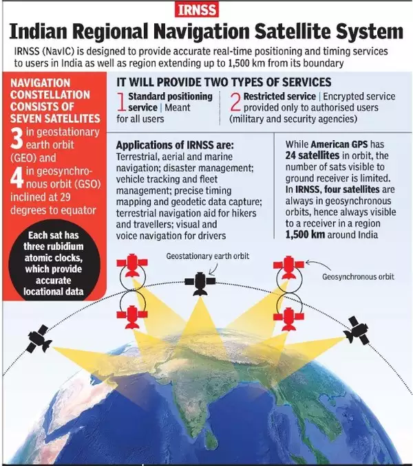

Q. With reference to the Indian Regional Navigation Satellite System (IRNSS), consider the following statements:
- IRNSS has three satellites in geostationary and four satellites in geosynchronous orbits.
- IRNSS covers entire India and about 5500 sq. km beyond its borders.
- India will have its own satellite navigation system with full global coverage by the middle of 2019.
Which of the statements given above is/are correct?
- 1 only
- 1 and 2 only
- 2 and 3 only
- None
Answer: (a) 1 only
NavIC
- It is an Indian Regional Navigation Satellite System or IRNSS.
- It was developed in India by Indian Space Research Organisation (ISRO) and its commercial wing ANTRIX.
- It consists of 8 satellites located at a distance of approximately 36,000 Km. Currently, 7 satellites are active.
- 3 satellites are in Geostationary Orbit (GEO)
- 5 satellites are in inclined Geosynchronous Orbit (GSO)
- The objective of the NavIC is to provide navigation, timing, and reliable positioning services in and around India.
- Working of the NavIC is very similar to the Global Positioning System(GPS) implemented by the United States.
- The NavIC is certified by 3GPP (3rd Generation Partnership Project) which is responsible for coordinating mobile telephony standards globally.
- The IRNSS System provides navigation solutions 24 hours a day, seven days a week, with position accuracy better than 20 metres in all weather conditions, anywhere in India and a region extending about 1500 kilometres around India.
- Furthermore, the NavIC system includes two frequency bands—L5-band and S-band—which makes it far more accurate than GPS.
- An Extended Service Area lies between primary service area and area enclosed by the rectangle from Latitude 30 deg South to 50 deg North, Longitude 30 deg East to 130 deg East.
- IRNSS provides two types of services, namely, Standard Positioning Service (SPS) which is provided to all the users and Restricted Service (RS), which is an encrypted service provided only to the authorized users.
- Applications of IRNSS are:
- Terrestrial, Aerial and Marine Navigation
- Disaster Management
- Vehicle tracking and fleet management
- Integration with mobile phones
- Precise Timing
- Mapping and Geodetic data capture
- Terrestrial navigation aid for hikers and travelers
- Visual and voice navigation for drivers