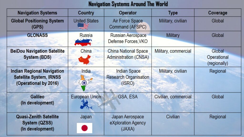

Q. Which one of the following countries has its own Satellite Navigation System?
- Australia
- Canada
- Israel
- Japan
Answer: (d) Japan
Satellite Navigation System
- Global navigation satellite system (GNSS) is a general term describing any satellite constellation that provides positioning, navigation, and timing (PNT) services on a global or regional basis.
- There are totally four Global Navigation Satellite System (GNSS) available. They are GPS (US), GLONASS (Russia), Galileo (EU), BeiDou (China). Additionally, there are two regional systems – QZSS (Japan) and IRNSS or NavIC (India).
- Quasi-Zenith Satellite System (QZSS)
- It (also known as Michibiki) is a regional GNSS owned by the Government of Japan and operated by QZS System Service Inc. (QSS). QZSS complements GPS to improve coverage in East Asia and Oceania. Japan declared the official start of QZSS services in 2018 with 4 operational satellites, and plans to expand the constellation to 7 satellites by 2023 for autonomous capability.
- Global Positioning System (GPS)
- GPS is the earliest GNSS system in the world. It began operating in 1978 and became accessible to everyone in 1994. The global positioning system (GPS) is a 24-satellite navigation system.
- GLObal NAvigation Satellite System (GLONASS)
- It is the global navigation satellite system of Russia. The second alternate navigational system in use is GLONASS with global coverage and comparable precision. It is run by the Russian Aerospace Defence Forces.
- Galileo
- The European Space Agency is building the Galileo GNSS constellation for the European Union. It is run by the European GNSS Agency. Galileo is a commercially and civilian accessible global navigation system. It has had a significant influence, with 26 satellites in orbit and more than two billion receivers in operation.
- BeiDou
- It is a satellite navigation system of China. Like any other navigation satellite system, BeiDou is made up of 35 satellites that orbit the Earth and transmit precise data all the time. The signal from the satellite travels from the satellite to the Earth’s ground stations and then to the receiver and vice versa.
- IRNSS (NAVIC)
- The regional satellite navigation system of India is known as the Indian Regional Navigation Satellite System (IRNSS), which was later given the operational title of NavIC or NAVigation with Indian Constellation. It is launched and operated by Indian Space Research Organisation (ISRO).